Visualizing Geography: Maps, Place, and Pedagogy
3/11/2013 - 7:06pm
Views: 427
Similar Content
Mapping technology has recently been the focus of much critical attention as evidenced by numerous efforts to develop new ways of visualizing physical and textual spaces. The proliferation of tools such as Neatline, The DM Project, Google Earth, and Walking Through Time has made mapping the stuff of both academic endeavours and everyday life.
Specifically on the academic front, the marriage of geography and literary scholarship raises interesting questions about how an individual imagines and experiences spaces. Projects like Map of Early Modern London, MappaMundi, and The Pegasus Data Project among others, are grappling with complex issues of space, place, and time, and sometimes they create encoding problems that expose epistemological flaws.
This forum will attempt to articulate some of these flaws and propose solutions that will help us better understand how literature, geography, space, and time intersect. Ultimately, we hope to foster an interdisciplinary conversation among scholars working on varied projects, from medieval texts to post-colonial movement, in order to gain new perspectives on the advantages and pitfalls of mapping text, space, and place.
 (1)
(1)
Questions
- How can web tools represent the literary spaces that a reader encounters (or imagines) in literature? What types of tools would fill the existing technological gaps in geospatial information studies?
- How do narratives travel and replicate over geographical space? What would mapping these processes yield? How can we do it?
- Is it problematic to represent literary and historical geography with modern interfaces like Google Maps? Should we be concerned that these visualizations may not be accurate representations of how our subjects would imagine space, or can we be content in uncovering new (and previously impossible) readings of old texts?
- How does using maps as a pedagogical tool affect our understanding of both real and literary environments? Does mapping change the way we make connections even when we aren’t thinking about geographical space?
 (2)
(2)
Hosted by HASTAC Scholars:
Cameron Butt, department of English, University of Victoria
Annette Joseph-Gabriel, department of French, Vanderbilt University
Rebecca Nesvet, department of English and Comparative Literature, University of North Carolina, Chapel Hill
Rebecca Shores, department of English and Comparative Literature, University of North Carolina, Chapel Hill
Forum Guests:
- David Borland, The Renaissance Computing Institute (RenCI)
- Laurel Bowman, department of Greek and Roman studies, University of Victoria
- Alex Gil, Digital Scholarship Coordinator, Columbia University
- Jen Jack Gieseking, Visiting Assistant Research Professor at the CUNY Graduate Center and Project Manager for JustPublics@365
- Martin Holmes, Humanities Computing and Media Centre, University of Victoria
- Alex Huang, department of English, George Washington University
- Todd Hughes, Director of Instructional Technology, Center for Second Language Studies, Vanderbilt University
- Janelle Jenstad, department of English, University of Victoria
- Joel Legassie, department of history, University of Victoria.
- Kim McLean-Fiander, The Map of Early Modern London, University of Victoria
- Jana Millar Usiskin, department of English, University of Victoria
- Greg Newton, Humanities Computing and Media Centre, University of Victoria
- Lynn Ramey, department of French and Italian, Vanderbilt University (mapping medieval travel at Discoveries of the Americas)
- Joyce Rudinsky, Associate Director for Digital Arts and Humanities, Institute of Arts nd Humanities (IAH), UNC Chapel Hill
- Katie Tanagawa, department of English, University of Victoria
Image Sources:
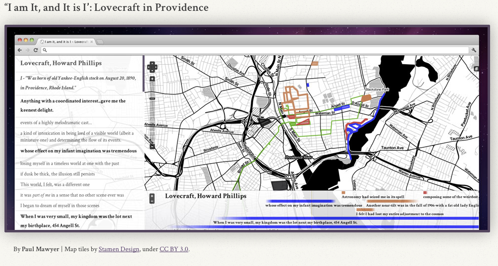
(1): “I am It, and It is I”: Lovecraft in Providence. Neatline Project By Paul Mawyer
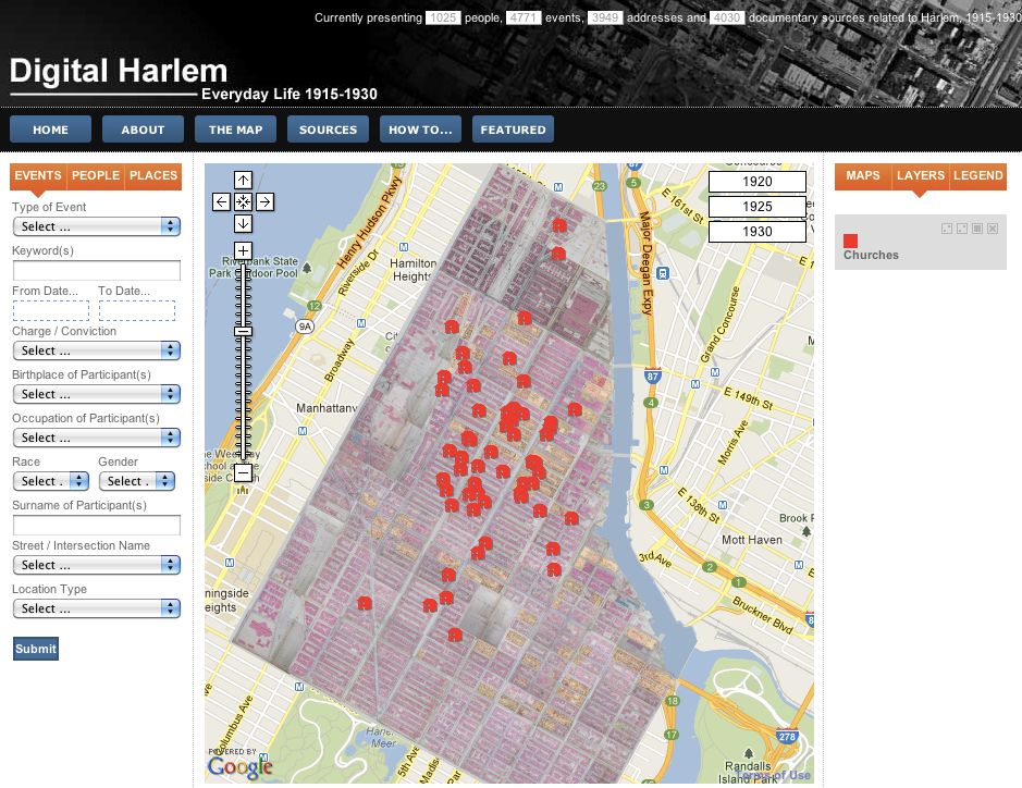
(2): Screenshot of Digital Harlem: Everyday Life 1915-1930, showing all of the neighborhood churches
Everyone is welcome to join the forum! Register on HASTAC to comment below.
sidebar last


Tweets
HASTACscholars @mozzadrella awesome! 11am-3pm EST. I'll send the link and chatroom invite. 12 minutes ago · reply · retweet · favorite
HASTACscholars @gerrycanavan cool. It kind of blew up beyond what I was expecting. In the end, the point is to get folks registered & get their feet wet. 13 minutes ago · reply · retweet · favorite
HASTACscholars @mozzadrella are you a wikipedia editor? have any time tomorrow to stop into the chatroom for assistance? 15 minutes ago · reply · retweet · favorite
HASTACscholars @gerrycanavan are you an editor? Have any time tomorrow? Would be great to have you in the chatroom for help... 15 minutes ago · reply · retweet · favorite

Group tags & topics
Academia
Arts & Design
Arts & Humanities
Calls for Papers
Careers, Publishing & Tenure
Coding & Development
Culture
Data & Information
Digital Humanities
Digital Media & Learning
HASTAC Scholars
Higher Education
International & Global
Legal, Licensing & Copyright
Online Identity
Open Source, Open Access & Open Web
Pedagogy & Teaching
Research & Methodologies
Social Networks & Social Media
Technology


literary worlds and cartography
One of the more powerful poetic images of maps is Anna Laetitia’ Barbauld’s image of a British woman looking at a map. In “Eighteen Hundred and Eleven” (1812), the woman:
. . . the spread map with anxious eye explores,
Its dotted boundaries and penciled shores,
Asks where the spot that wrecked her bliss is found,
And learns its name but to detest the sound.
(ll. 33-8)
(From Project Gutenberg, provenance unknown)
This woman is “exploring” in cartography, to understand how war and imperialism have destroyed her family and possibly imperilled her life.
Barbauld’s map-reading scene anticipates the Victorian geographer Lady Jane Franklin’s search for her husband Sir John Franklin and his Arctic expedition of 130, which disappeared in 1845 and has never been located. Lady Franklin did not just passively read cartography, she influenced it, by commissioning fruitless rescue missions and somewhat more productive recovery expeditions that mapped much of Upper Canada. (She also lobbied successfully for her husband’s erroneous immortalization as the discoverer of the Northwest Passage.)
Many more Victorian readers saw literary worlds cartographically. One of the nineteenth century’s unsung bestsellers, James Malcolm Rymer’s The String of Pearls--the origin of the Sweeney Todd legend--is almost incomprehensible without a map of London’s Temple Bar area. As it was disseminated far beyond London, with a New York edition published before the end of the century, most readers probably knew Rymer’s London only from maps, illustrations, and other stories.
In the 1880s, Edwin A. Abbott’s Flatland introduced a world adequately represented by a map. Flatland exists in only two dimensions. As a satirical dystopia that mirrors Abbott’s England, Flatland might be considered a 1:1 scale map of England. Flatland is viewed from above and below by its psychopomp, the imperialist Sphere, so it looks like a map. In contrast, the pompous Sphere is a globe, so in Abbott’s parable, the world looks in the mirror of the map and fails to recognize itself. Perhaps in this forum, we shall do better.
visualize "map view" & "street view" at the same time?
One of the more interesting things I've come across in the geohumanities is the distinction between the two primary ways in which we tend to visualize geography. I think the best way to describe these two visualization types is in Google's terminology: "map view" and "street view." For Michel de Certeau, this distinction is the difference between "the knowledge of an order of places" (i.e. seeing from above) or "spatializing actions" (i.e moving through a space).
For me, these two visualizations of geography are mutually exclusive: I can never conceptualize both images at the same time. It's like a gestalt drawing: I can see the rabbit and the duck, but never both animals together. And I think that this statement is true despite the miracle of mobile phones. Even staring at a blue dot that I understand represents my body as viewed from above, I can not completely merge what I see around me with what my phone imagines the spaces around me look like from above.
It's possible that this is a personal handicap and that other people can indeed conceptualize both the street view and the map view at once. I'm thinking now of a video games I played growing up, Goldeneye, in which players impersonate James Bond characters trying to kill each other. In these games, the first person view simulates the player "walking" around, gun drawn, annihilating their enemies or, in my case, being gunned down by apparently invisible opponents. Let's call this the street view. There was also a map view, a small series of squiggles and dots in the corner of the screen that outlined the terrain of the virtual space. Now the reason I used to get killed a lot when playing these games was that I couldn't make sense of the map view, or when I could, I couldn't make that information relevant to my understanding of the street view. My opponents, however, played that game every day and thoroughly understood how to make connect their knowledge of the "order of places" with their "spatializing actions."
Now bear with me, because I think there's more to this anecdote than my repressed anger at losing every single game of Goldeneye I ever played. With practice, my friends had successfully fused these apparently opposite visualizations of the same space. But I think it's important to note that, even in understanding the relationship between these views, they could not successfully see both at the same time. Their eyes would repeatedly dart back and forth between the map and the screen showing the street view.
Which leads me to conclude, though not empirically, that we can not conceive of a space in both a street view and a map view at the same time.
Does this theory hold up? Has anybody managed to do so? Are there any tools out there that reflect or disprove this dynamic?
merging two views
I’m glad I’m not the only one who has difficulty merging map view and street view in my mind. Yes I agree that “we cannot conceive of a space in both” views simultaneously, but I would like to try.
My current project (still in very early stages) is attempting to do this. In trying to plot the movements of 2 women political activists throughout French West and Central Africa I definitely want to merge both views. I’m currrently exploring Neatline to craft a narrative that will allow the map viewer to very literally see the movement through space via points on a map but also to “be” in the space, it’s landmarks and terrain...and I say “be” because to access googgle maps street view you need to place yourself (i.e the little yellow man) onto the map. I’m not sure if this is possible. Currently the map viewer would still have to toggle between one and the other view.
So to add to the questions above, what are the implications of our (in)ability to simultaneously be in a space and have a bird’s eye view of it? In particular, what are the implications for the way we read say travel narratives that seek to give us both views? Do such texts bring us as close as we can get?
Envisioning Ability to Combine Views & Visualization
Annette, your project sounds fascinating. And your description calls attention to the reasons why it's not enough for us to plug our data into existing interfaces like Google Maps, why we need new interfaces. Why on earth should the travels of two women be represented on a map by a "little yellow man?" And why does Google think that this man represents the reader of the map in their armchair, projected, or remembered travels? What does that say about Google Maps' assumptions about the archetypal voyager's gender and/or race?
And this is a great question, Annette... especially for readers of FLATLAND.
To recap: Flatland is 2D. Inhabitants - shapes - experience world as plane. Above and below don't exist. "Spaceland," home of the Sphere, is our 3D world, and Flatland cuts through it like the rings of Saturn.
So, do the Flatlanders have an advantage in their not needing to constantly translate and shift between map-view and street-view perspectives, as in Flatland these are the same?
Would a creature from the 4th Dimension (Hyperland?) have too many views of OUR world? (Map, Street, and hyperspatial?)
(My sketch)
Geography and temporality
I also struggle with envisioning "street view" and "map view" at the same time, and can only get close to reconciling them with the help of layering or other graphics like a "you are here" outtake on the same page. But this issue hits another vital aspect to mapping literary geography: what do we do with the temporal elements of our visual renderings? How do we reconcile, or at least articulate, the distance between us and the literature we're mapping? The real and the imagined space? The present and the past?
All of these issues come up in the Anglo-Saxon Chronicle, a group of 8 annalistic texts whose first version began in the 9th c and whose last ended in the 12th. The annals contain prose, poetry, short stories, and genealogies. And although each entry begins with a date, most of them also contain reference to place.
When looking at the 10th century entries that are unique to each version (places only mentioned by A Chronicle, B Chronicle, etc), we see clearly particular spatial preferences :
It seems unlikely that the scribes had much (if any) access to maps, but texts like the Old English Orosius complicate our understanding of Anglo-Saxon sense of space. The translator of Orosius's geography/history text added "interviews" from two contemporary sailors, Ohthere and Wulfstan, who seem to dictate (with occasional anomaly) their voyages in the White Sea and Baltic.
But how many of the scribes over the Chronicle's 3+ centuries of creation had ever seen a map, especially of England? How did they conceive of their own kingdoms? How are changes of power among Wessex, Mercia, and Northumbria, and with ever-increasing waves of Viking invasion entered into these temporal registers?
Most important to this forum, I think, is, "what happens when we visualize spaces that were imagined differently by their authors?" This question leads us back to the issue of street view v map view-- both mark place and change in different ways, and both are perhaps misleadingly real. Do we have any business at all using modern maps to imagine the ancient past, or satellite maps to create imagined spaces? What are the plusses and pitfalls?
Great post and questions
Hi Everyone,
Thanks for organizing this forum.
I really enjoyed your question Rebecca, and it's something I consider a great deal because many of my historical actors (missionaries) have a highly religious worldview. Trying to map this perspective on to existing google or satellite maps has not really produced the landscapes or visions I'm trying to map.
Does any one know of alternative software that allows you to physically alter the sizes and shapes of countries? I often find myself wanting to alter the maps I'm working on so that important landmarks and interests are propotionally larger. Such a software would perhaps bridge the gap between street and map view, while at the same time allowing us to make space a much more contigent variable in our analysis of the past. I've not had any luck finding such s software but it would be a great tool.
Please feel free to share any leads!
Cheers,
Zoe
Old and New Maps
Sorry to be late to the discussion! But so far, it's fascinating.
I'm intrigued by two of the points, which seem to intersect:
1) The question of trying to visualize two different views of the same space at the same time and the narrative equivalent of that, and
2) How should we use old and new maps? Should we try to see what the author may have seen? Is there a morality of mapping?
I agree with Cameron that there are different capacities for viewers. Brains are wired uniquely, and some people prefer street view (3D) and some prefer flat (2D), and some people seem to pass easily from one to the other. But the positioning is so very different-- one with a bird's eye (narrative equivalent of omniscient) and the other with a first person view. [I wonder what a game would be like with a 2nd person view? That would seem the closest to merging the two.] This would make a fantastic model for a text that switches between points of view. I can imagine playing through the text (I'm currently a little obsessed with gaming models for the humanities) with a change in point of view, as Annette suggests. What would that bring to the reader? Would the reader "see" or experience the text more as the author did? Which brings me to the second point.
What does it bring us to see things as they may have been seen 50 or 1000 years ago by an author? Like Rebecca, I work with medieval maps that don't geo-reference precisely to modern maps. We tried an exercise to geo-rectify a medieval map, and while it was possible, the result was rather amusing; I'm not sure it was helpful to anyone, though it did show the impossibility of such a task. Here I quote from one of the students in the course, Katie Gandy:
Indeed, when one looks at a medieval map it looks a lot more like the sort of map Rebecca and Zoe imagine for religious travelers-- Jerusalem at the center of the world, out of proportion objects and images of peoples who intrigued more than one medieval mapmaker. Here's a close-up of Ireland, England, part of France on the Catalan Atlas of 1375:
Geo-political and religious references are marked on the map-- flags and churches for Nantes and Paris, flags representing factions and alliances in Ireland and England, and then a fairly long section of text, upside-down on the left which reports travel writing accounts of what can be found in various areas of the map. This is pretty close to seeing from a bird's eye (the map) and street (first-person text) in the same space, though your eyes must dart between the two because those really are two positions that cannot inhabit the exact same space at the same moment.
As for the morality of using modern maps for older texts, or even old maps to read old texts, I think it's the combination of these points of view, as long as we acknowledge our own position and the impossibility of inhabiting anything other than our own time and place, that gives us the most possibility for insight. With every map being political and every mapmaker and author having to work with his or her own impressions and preconceptions, I don't think we could ever see what any author or mapmaker really saw, but it adds something for us to know that Nantes was almost as important as Paris in this mapmaker's eyes (why, we must ask?) and that Ireland and England are roughly the same size. But we know that is worthy of remarking because on a modern map, Paris is much more central (geographically) to France and Ireland is far smaller than the UK.
Mapping touring theatre works
What does it mean to map world-wide theatre activities? Why would we want to do it? As the co-founder of http://globalshakespeares.org/ (an open-access performance archive), I am intrigued by two sets of your questions:
Maps and mapping as a pedagocial and research tool are central to the field of global Shakespeare studies and to our understanding of touring performances. In one of the "wings" of our Global Shakespeares project (http://web.mit.edu/shakespeare/asia/), we experimented with Google Maps to plot the frequency of plays performed (where is Hamlet most popular?), locations of productions, and touring trajectories of select productions across continents.
Mapping geopolitical space is not the only concern here. We also have to consider a wider and longer history of globalization. In other words, we have to map time and space.
The data can be viewed as a table, plotted on a world map withsatellite and hybrid map-satellite options, or timeline. Dynamic timelines and maps used in conjunction with faceted browsing and tagged video, allow users to trace the paths of production and diffusion of Asian and touring productions. If ‘distant reading’ and graphs, as Franco Moretti suggests, can bring about important changes to the study of literature, such tools for visualization are important for performance studies. For any given period scholars tend focus on a select group of canonical works, and, as a result, they have allowed a narrow slice of history to pass for the total picture.
Maps and timelines of the large number of productions can suggest new questions and unexpected relationships, and—especially important for the study of world-wide performance and emerging forms in a global context—counter the biases of metropolitan constructions of the field of study.
Cameron Butt raisd an interesting question (above) about Google's terminologies: "map view" and "street view." What might we do with "street view" and on-the-ground knowledge of a specific performance space? Michel de Certeau's points about the surveyor's knowledge of a land and "spatializing actions" is useful, but there is more work to be done regarding 3D modeling and mapping.
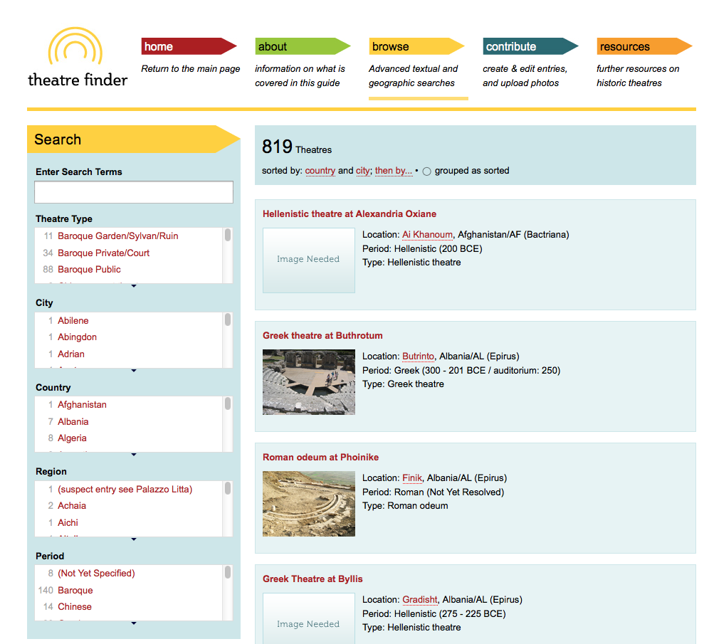
Frank Hildy does not engage in maps, but he does "map" in metaphorical ways theatre buildings across the world in his Theatre Finder project (http://mith.umd.edu/theatrefinder/).