|
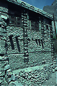
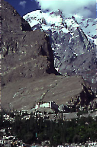
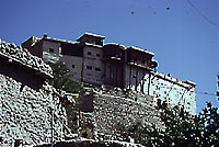
by Li Lian Tan INTRODUCTION The setting of the Baltit Fort is arguably unrivalled in Pakistan. It is set at the head of the Hunza Valley in the Northern Areas amongst some of the highest mountains of the world, overlooking the valley settlements which it was built to protect. While it has lost its defensive role in modern times, the Fort remains a symbol of the region's history and culture. It is a synthesis of the architectural form, domestic lifestyle and belief systems of the region, providing insight into the values of the Hunza people. The Fort has expanded with its increasing importance over the centuries and been adapted to changing needs and functions. Carbon dating tests indicate that some parts of the structure existed as early as the 13th century, with the last major modifications made at the beginning of the 20th century before conservation was undertaken in 1989. It is currently being re-used as an ethnographic museum. CONTEXT Physical Prior to the 1960's access to the region was by either four-wheel drive vehicle, when the season permitted, or by overland trek on foot from the villages of Gilgit, in the lower valley, taking up to four days. With the advent of the Karakoram Highway, which linked Islamabad to western China, Karimabad is now accessible by road. The town of Karimabad is situated in a broad green valley beyond the main gorges of the lower Hunza Valley. The valley is made up of a complex series of cultivated terraces and plateaus supported by rubble walls, and watered by the age-old Ultar irrigation system that channels glacial waters to the valley. Because of the scarcity of irrigation water, the possession of arable land is jealously protected. The entire valley floor is a mountain desert with only 100 to 200 millimeters of rainfall per year. Baltit Fort is located at the top of a natural amphitheater formed by the terraced slopes. The site was carefully chosen to control water extraction routes from the Ultar channel behind. Settlement Patterns Historical, Social, Economic In 1891, the British waged a military campaign against the Hunza and Nagar kingdoms and after a short resistance the British took up residency in the Fort for a short period. Immediately after this, the British installed one of the members of the ancient Mir ruling family with whom they established good relations. Given the newly peaceful conditions, Baltit's walls came down. And with the cessation of hostilities with the state of Nagar, the people of Baltit began building settlements in the agricultural valley below. In the late 1960s a major new road was begun in the area as the result of collaboration between Pakistan and China. Commissioned in 1974 and opened to foreign tourists in 1979, the Karakoram Highway opened the Northern Areas to Pakistan and the rest of the world. The influx of foreign visitors and their money began to change the local occupations of the 5,000 residents and their employment patterns in radical ways. Agriculture-related earnings began to give way to income generated from the increasing tourist trade. Baltit's largely Isma'ili population considers the Aga Khan their spiritual leader. Baltit Village was renamed Karimabad in honor of the current Aga Khan, Prince Karim. The Aga Khan has and continues to play an active role in the development of the village and the preservation of its culture in partnership with the local community. Some of the projects endorsed and funded, partially or in full, by the Aga Khan network include the installation of sanitation infrastructure, the rehabilitation of streets and public open spaces, the conservation of individual buildings and building elements of special architectural and cultural value, the establishment of a girls school, the introduction of modern farming techniques to farmers and of course, the conservation of the Fort. The new trades and occupations now supported by tourism include retail commerce, hotels and restaurants, guides and tour agents, and transportation of visitors in all-terrain vehicles and mini-buses. There are also administrative government jobs and tertiary sector activities. Agricultural land has become vulnerable to the construction of buildings, as all new activities require buildings and infrastructure. THE PROJECT The Building Using archaeological techniques during the survey and conservation of the Fort, more than 70 phases of construction were identified. One of Baltit's earliest phases, dated by Carbon 14 tests, was found to be more than 700 years old.1 It became clear that the present building grew as a response to local and external pressures. The original glacier moraine pinnacle, much like that still to be seen to the north of the Fort, was first settled by one or two single-story houses, one with an attached defensive tower. This form of house was common throughout the valley, and examples are still seen in the Indus valley south of Gilgit. Attached to the houses would have been animal pens an overall cluster configuration much like that still used in the historic core of Karimabad village. In the early years of this century, during peaceful times, the Mir gentrified the whole top floor of the vernacular Fort to transform it into a palace with many features drawn from British colonial buildings of the Punjab. The first floor was left much as it had been in the 19th century. The area for women and the Mir's bedroom, on the second floor behind the grand reception rooms, were also maintained in a traditional arrangement. These constitute some of the finest rooms in the Fort and have been left untouched. Other second floor rooms were modified for the Mir's private use, with the installation of fireplaces and western furniture, and the use of wallpapers, curtains and cement renders. The remodeling also included the introduction of a semi-round royal dais, mud-block walls, colored glass windows, a Tibetan-style lantern, wood-planked and decorated ceilings, and wall mounted fireplaces in many of the modernized rooms. Two mosques on the roof were removed leaving one that has since been fully reinstated. Finally, one major four-story tower was demolished at the north end of the Fort, as witnessed by a blocked doorway in the present north façade. The fort was last fully occupied in the 1940s and the family now lives in a more modern residence nearby. An American aid worker lived in a few rooms of the Fort in the 1960s. Physical Description The main west elevation is two and three stories high with roof level cantilevered timber diases. The east elevation is generally single story but the southwest-corner tower is four stories high. There are 35 internal rooms connected by a warren of low corridors on varying levels, reflecting the various phases of the Fort's construction. Life inside the Fort was organized according to the well-ordered room arrangement, and new rooms were added for new functions. On the ground floor, the oldest rooms such as the queen's apartments, the storage rooms, prison and kitchen reveal a traditional way of life. The additional rooms on the first and second floors, of a larger size with better lighting and more facilities, provided more comfortable living for the royal family. These rooms were mostly used in summer. In winter the inhabitants retired below to the darker but warmer rooms. In the 19th century, the west façade was modified by the addition of an outer layer to improve the external military appearance of the fort and provide, within the wall structure, special guardrooms for security around the only access door. At the beginning of the 20th century, the building was modernized and its defensive role modified with the addition of wooden verandahs, reception areas and guestrooms, all constructed to take advantage of the spectacular scenery. Structures, Materials, Technology, Construction
and Current State At corner points and where internal cross walls form a "T" junction with the external wall, timber cribbage work is found. Here, square timbers are built as columns up the full height of the wall and are pegged together. The inside of the timber frame is infilled with soil and small stone, loosely placed or poured in as a stiff slurry from a place higher up in the wall. In between the longitudinal timbers, both externally and inside, the wall faces are constructed in coursed random stone work or solid brickwork, these materials using a soil mortar. The timber building technique is intimately related to seismic issues. Its main advantage is in giving a wall the ability to withstand tensional forces along the plane of the wall and also across it. It is also an excellent system for allowing considerable differential vertical movements to occur in materials normally only able to resist compressional stresses. There is a complex mixture of structural performance. Each additional wall is not keyed into the pre-existing ones so that they do not share structural support and can independently move. This can be an advantage where there is a variable foundation medium, but since the system was not designed for a long life nor for simple repair, some walls had become structurally defective and became excessively reliant on their adjacent wall for structural support. They would have fallen down without this support. Furthermore, most of the rooms were designed as single story structures. Second and third story additions had excessively surcharged the lower walls and foundations. This was carried out without always considering the structural system of the lower rooms. For example, the upper-level walls were misaligned with regard to those below. While this helped generate the more spacious rooms where important international guests could be received and entertained, it also resulted in structural deformations. Also, the outer defensive walls were in places very tall and were built on the steeper slopes where slope stability was more of a problem. Roof structures were not integrated with the structural system, thus their potential to act as a shear plate to resist torsion motion during earthquakes was never realized. Also, there was considerable decay of wooden roof beams and planking and rush roof covering due to the penetration of rainwater. Soil brick infill was used for some of the later phases and was a replacement in the north and rear elevations. The bricks were predominantly located at exposed places and hence were extremely decayed. In many places the materials had fallen out of the panels. Generally all soil mortars were in a decayed state and often missing. Surprisingly the timber of the main structural frame was found to be in sound condition in both exposed and covered positions. In general, the Fort was in a dilapidated condition and it was imperative that the decay process be halted and the building restored for posterity.
CONSERVATION PHILOSOPHY AND OBJECTIVES The highest priority was to retain the historic character and appearance of the Fort. Thus, the impressive structure of the Fort before conservation began was considered the end product of a series of changes which, even if less than 100 years old, was to be respected in the conservation of the building. Through the rigorous application of the highest international standards of conservation throughout all phases of the work, the project was to serve as a demonstration of excellence throughout Pakistan and the region. Also, of great importance in the project was the training of local personnel in the principles and methods of conservation to establish a pool of qualified professionals capable of undertaking future restoration projects. Special research was intended to stimulate the study and understanding of important structures in the Northern Areas, and encourage scholarly exchange, dialogue, and publication. (The research was conducted but there has been very little follow up actually in the country.) The wider range of expertise required in this conservation project was to act as a stimulus and provide training opportunities in a broad range of sciences, from geology to archaeology, from engineering to timber construction, and from museum to public and community administration. CONSERVATION PROGRAM INTERVENTIONS Re-use of the Fort responded to a variety of concerns. The project needed to meet the constraints imposed by architectural conservation, to enhance and promote the cultural values of a living (and evolving) culture, to contribute to the economic opportunities for the residents of the village, and to generate sufficient income to sustain its operation and maintenance costs. Accordingly, the main uses selected for the restored Fort were those of a museum and active cultural center with associated facilities. The Fort is expected to act as a focal point for research on local traditions and as a center for exchange between international institutions interested in the Northern Areas who are in need of a base for their fieldwork. The architectural features constitute the main focus of attention. The program involved the complicated conversion of a private residence into a public facility. This included the installation of a new, suspended floor for the area to house a public library. This suspended floor permits visitors to see beneath it and inspect the archaeological features discovered during the early engineering works. A kitchen was also created and an emergency staircase inserted. Plumbing and lighting were also introduced. Five old houses adjacent to the Fort were acquired to provide space for ancillary facilities such as a ticket office, storerooms, showrooms, workshop facilities, and a coffeehouse with public toilet facilities. Modern materials were used whenever interventions could not be achieved to appropriate levels of safety with traditional technology. Modern materials were determined necessary for the tie ropes, soil-reinforcement and stabilization, and as wood preservatives. Thus, "Parafil" tie ropes and "Geo-mesh" soil-reinforcements were used. The new foundations are vertical columns of cribbage timber and stone sunk to hard moraine, six meters below ground level. None of these conservation works involved alteration of the original structural system or its proven resistance to earthquakes. All modern insertions needed for the adaptive re-use of the Fort were designed in such fashion as to permit, if necessary, their removal or alteration in future, without damage to the adjacent original fabric. Furthermore, when new elements were required, the modern materials and techniques employed are readily distinguishable, such as the metal grille floor, or the emergency staircase. Considerable research was devoted to improving the Fort's roof structures, particularly to help prevent rainwater penetration, as well as scuff and damage caused by the shoes of visitors. A modern waterproof membrane was incorporated into the roof system. More effective drainage gradients were also created in the new coverings. Stages or Schedule of Construction 1980: Brief condition survey of the Fort
by Richard Hughes. THE PLAYERS The Aga Khan Trust for Culture (AKTC) engaged the team of Richard Hughes and Didier Lefort in 1985 to develop proposals that would save the Baltit Fort from further decay, and to formulate an imaginative program for the full-scale conservation of the complex. Richard Hughes is an English engineer who specializes in seismic proof structures and soil buildings. Didier Lefort is a French architect and designer, who was also working in North Pakistan on health and educational projects. Early support for the project was granted by the Royal Geographical Society as a complement to its 1980 International Karakoram Expedition, and significant additional funding for the early survey, documentary research, and project formulation was provided by the United Nations Development Program (Pakistan) in 1984. From the mid-1980s the project was coordinated by Hasan-Uddin Khan at the Secretariat of His Highness the Aga Khan in France. Before implementing the conservation plans for the Fort, an appropriate legal mechanism had to be put in place to transfer Baltit Fort from private to public ownership. In 1989, the present Mir of Hunza donated the Fort, which his family had owned for centuries, to the Baltit Heritage Trust (BHT) which was established as a caretaker and operating institution for the Fort. This donation to a public entity, in turn, enabled the AKTC in Geneva to sponsor the restoration work. The first person appointed on-site was Sohail Akbar Khan, a young architect whose early role was to see through the conservation programs established for the Fort. Because heavy engineering was to be the focus for the first four years of the site program, Andrew Cox, who was working with Arup Associates in London, was engaged as resident structural engineer. The site workers were all drawn from the local community. Supplementary training for Sohail and a number of young architects and engineers from the Northern Areas was obtained through conservation courses in Europe during the less active winter months. The Aga Khan Housing Board, with its proven building experience in these areas, took on the responsibility of construction management. The Dawood College of Architecture in Karachi sent students and professors to work on the site and to monitor and evaluate student projects. A manager and a curator/librarian were recruited in the summer of 1996, during the last phase of the museum installation. To augment the restoration of the Fort, a Development Plan for Karimabad was drawn up. Arif Hasan and Reza Ali, urban planners, were enlisted to develop and sustain the physical environment around the fort and the relationship of the Fort to the town. Later this aspect of the project was taken over by the Aga Khan Trust in Geneva. This work did not form part of the conservation budget. Personnel Involved in the Project: Project Technical Monitor Richard Hughes,
London, UK
FINANCING The cost of the restoration is estimated at $2,000,000, which does not include the cost of bringing in foreign consultants and experts. The cost of the materials and labor alone amounted to $650,000. AKTC made the Baltit Fort Restoration one of the key projects of its Historic Cities Support Program, contributing $800,000 to the project. A preliminary program for the re-use of the restored Fort as a museum was established in consultation with the BHT, which was also given responsibility to secure long-term funding for the Fort's operation. AKTC spent approximately $1,500,000 on conservation and associated activities such as planning and environmental improvement in the village of Karimabad. These objectives were furthered and endorsed by the Getty Grant Program ($200,000), which provided additional funding for the conservation of the Fort through the BHT in 1992. NORAD, the Norwegian bilateral aid agency, financed important acquisitions for the future museum collection in the Fort as well as environmental improvement projects in the village.
Endnote 1. Tests on the structure were carried out in London in the 1980s under the supervision of the engineer Richard Hughes.
Bibliography Baltit Heritage Trust (Publication for the opening of the Baltit Fort.) September 1996. Clark, John. Hunza: Lost Kingdom of the Himalayas. Karachi: Indus Publications, 1980. Davey, Peter. "Aga Khan in the Hindu Kush." Architectural Review, vol. 200, no. 1198, (Dec 1996): pp. 11, 13. Davey, Peter. "Hunza Hope." Architectural Review, vol. 201, no. 1200, (Feb 1997): pp. 67-73. Historic Cities Support Programme: Karimabad and Baltit Project Development. Geneva: Aga Khan Trust For Culture, 1996. Hughes, Richard and Lefort, Didier. "At the Roof of the World: The Baltit Fort." Mimar vol. 20, (April-June 1986): pp. 10-19. Keay, John. The Gilgit Game. Karachi: Oxford University Press, 1990. Khan, Hasan-Uddin. "Cultural Continuity at the Roof of the World: The Baltit Fort." Herald (Karachi: December 1996). Khan, Masood A. "Catching a Passing Moment: The Redeployment of Tradition." Traditional Dwellings and Settlements Review vol. 7, no. 2, (Spring 1996): pp. 43-62. Landecker, Heidi. "Pakistani Treasure." Architecture vol. 86, no. 3, (March 1997): pp. 88-93. Shaw, Isobel. Pakistan Handbook. Hong Kong: The Guidebook Company Ltd., 1989. Illustration Credits All illustrations used here are credited to Professor Hasan Khan's personal collection. |
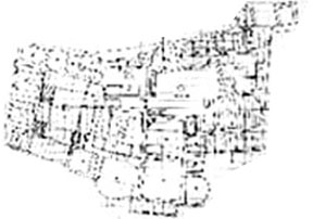
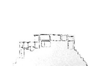
Image 3: Plan of the fort.
Image 4: Section through the Baltit Fort
|
 |
|