|
|
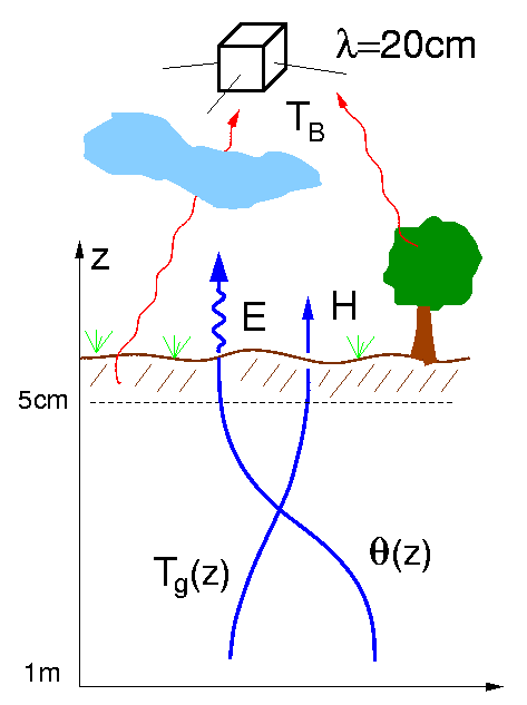
| The limitations of current techniques for measuring soil moisture can be partially overcome if data assimilation techniques are used to combine radiobrightness measurements with other relevant information, such as soil maps, land use data, and meteorological measurements. These complementary sources of information can be related with physically-based models that describe the connection between land surface states and measured radiobrightness. Since the measurements may be noisy and the models are only approximate, the data assimilation procedure must explicitly account for both measurement and model errors. This prevents the procedure from relying excessively on either source of information. |
| In this project we have developed a new four-dimensional data assimilation algorithm which is suitable for hydrologic applications. This algorithm is based on a land surface model which describes changes in soil moisture, soil temperature, and canopy temperature over time and three spatial dimensions. The land surface model captures key physical processes at the land-atmosphere boundary while meeting the stringent computational requirements of a practical data assimilation system. Computational efficiency has been achieved by dividing the model domain into laterally uncoupled one-dimensional vertical columns. These columns are related through horizontal correlations in the various inputs which force the model. The use of a column-oriented model also makes it possible to estimate profiles of soil moisture and related variables. |
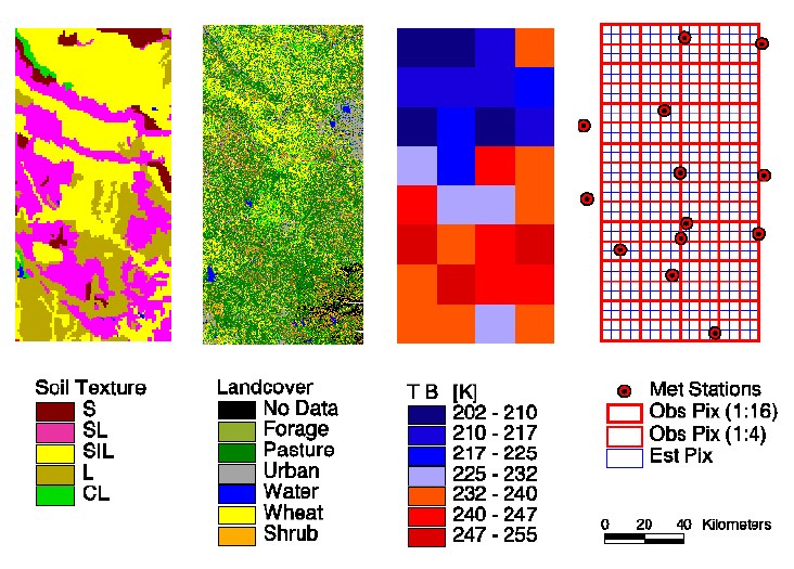
Typical Information Available for Soil Moisture Data Assimilation <click to enlarge> |
We have used our data
assimilation algorithm to investigate several design issues which are important
in practical applications:
|
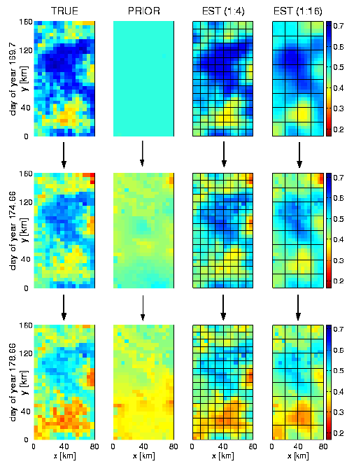
Typical Soil Moisture Downscaling Results <click to enlarge> |
Our synthetic downscaling experiments show that it is indeed feasible to estimate land surface variables such as soil moisture at horizontal resolutions smaller than the resolution of available radiobrightness observations. The additional information needed to make this possible comes from soil, land use, and meteorological data available at smaller spatial scales. Even for downscaling ratios of one to sixteen (each observation pixel contains sixteen estimation pixels), it is possible to capture many of the fine-scale features of the true fields. This implies that brightness images with a resolution of 40-50 km may be sufficient to support soil moisture estimates on a scale of 10 km, provided that sufficiently accurate model inputs are available at the finer scale. |
| In other synthetic experiments we have demonstrated the ability of the assimilation algorithm to satisfactorily estimate soil moisture even if quantitative precipitation data are not available. This is possible because radiobrightness data are sensitive to precipitation-induced changes in soil moisture. Although soil moisture estimates improve if both radiobrightness and precipitation data are available, it may be sufficient in practice to provide the assimilation algorithm with information on the timing of rainfall events. |
| In our final set of synthetic experiments we have assessed the influence of the length of the data assimilation window and we have considered the operational problem of specifying an approximate prior covariance at the beginning of each window. Our investigation of this issue indicates that it is best to match the assimilation window approximately to an interstorm period. Moreover, each window should be chosen to ensure that there is sufficient time for errors in the approximate prior covariance to damp out before the next measurement is processed. If we observe these guidelines we can obtain nearly optimal estimates, even though computational limitations force us to naively re-initialize the assimilation windows. |
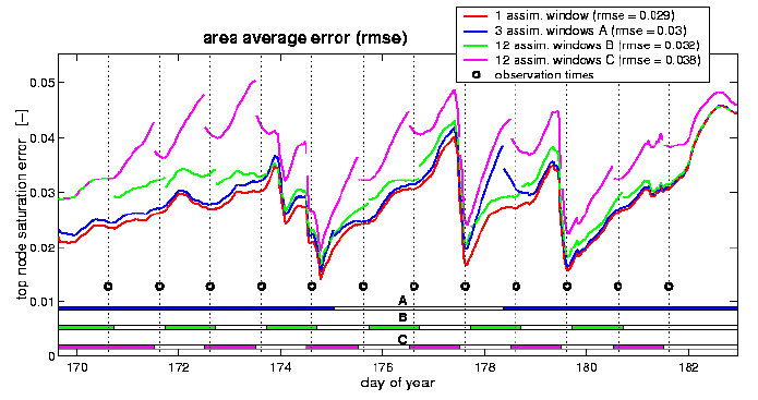
Investigation of Window Length and Covariance Initialization <click to enlarge> |
| It is likely that land
surface estimates produced by our assimilation algorithm could be improved
by adding other types of measurements, such as infrared observations of
soil temperature and lower-frequency microwave measurements (for example
C-band, 5.3 GHz). Multi-platform and multi-frequency measurements can be
naturally included in the assimilation algorithm if the measurement equation
is modifed accordingly.
Further improvements in computational efficiency may be required before continental-scale applications of hydrologic data assimilation become feasible. Given the highly nonlinear structure of land-atmosphere processes and the high complexity of real world applications, any large-scale land surface data assimilation algorithm will inevitably be a compromise between realistic physical representations and computational feasibility. We believe that the approach outlined here stikes a reasonable balance on this continuum. |
| Recent
Publications
Reichle, Rolf H., Variational
Assimilation of Remote Sensing Data for Land Surface Hydrologic Applications,
PhD Dissertation, Massachusetts Institute of Technology, Cambridge, MA,
Feb 2000.
For more information, contact Rolf Reichle at reichle@janus.gsfc.nasa.gov or Dennis McLaughlin at dennism@mit.edu. |
|
Home | Overview | People | Projects | Publications |
| Copyright 1998-2000 Massachusetts Institute of Technology |