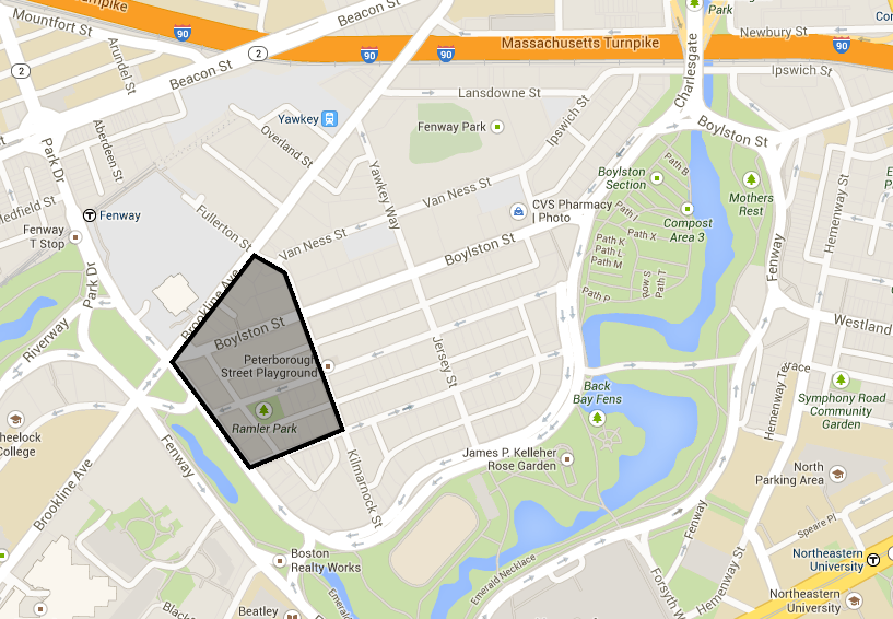
I selected the blocks bounded by Park Drive, Queensberry Street, Kilmarnock Street, and Brookline Avenue, as shown in Figure 1. This site, in Boston’s Back Bay/Fenway Park neighborhood is the intersection of four competing natural, economic, and social forces. First, its natural forces are dominated by the effects of the Emerald Necklace, a water management and beautification project designed by the famous landscape architect Fredrick Law Olmsted. Second, high social and political pressure to preserve the Fenway neighborhood’s historic character shapes the area’s developments. Boston’s famed Fenway Park lies just blocks to the Northeast, and influences the transportation, economy, and the businesses established nearby. Third, residents are very transient, as the several nearby universities and colleges attract students, young professionals, and the businesses they cater to. Fourth, commercial development influences are prominent, because the site lies at the intersection of several key Boston streets – Brookline Ave, Boylston St., and Commonwealth Ave.
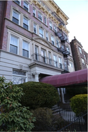
The site abuts Boston’s Emerald Necklace. Professor Spirn mentioned in class how parks make a tremendous impact on cities, by increasing the desirability to residents and businesses and by cleansing the air and absorbing the city’s water naturally. In the long run, they can define cities for centuries, as is the case with Central Park in New York or Lincoln Park in Chicago. The Emerald Necklace is the largest part of the Boston area park system, and it was planned and implemented by Olmsted to bring not only recreation and beauty to Boston, but also to supplement the city’s rainwater runoff system. Park Drive is lined with well-maintained homes of a middle-class or upper-middle-class appearance, likely as a result of their proximity to the adjacent parkland, as visible in Figure 2. Visiting the area raised several questions about the interplay between my site and the park. What was there before the Necklace? The Necklace was constructed in the 1860s, but Boston has been settled for much longer. How did the area change with the introduction of the park? When I visited, the Necklace was fenced off for renovations – what changes have been made to the park, now and in the past?
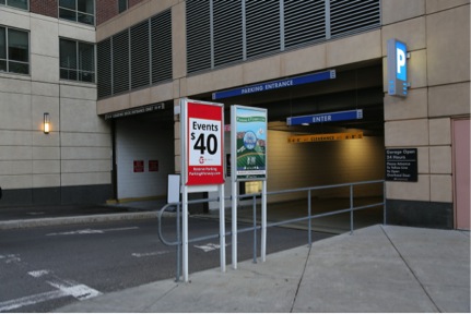
The proximity of Fenway Park places multiple competing economic and social pressures on the area. Scouting the site, I noticed many surface parking lots advertising relatively pricey parking for Red Sox events, as seen in Figure 3. Two MBTA T-stops are located within a ten minute walk of the site, as visible in the Google Map (Figure 1). Sporting events create a very high demand for transportation options on a seasonal basis, but their effects on the infrastructure and the neighborhood is permanent. Fenway Park is also an ‘epitomizing location’ as Clay would describe it, because it is a “special [place] … [carrying] huge layers of symbols that have the capacity to pack up emotions, energy, or history into a small space.” [1] The interactions between the permanent residents, the businesses, and the stakeholders of Fenway Park likely have a political history with economic undertones. Analyzing these interactions will help me to better understand the past, present, and future of the site.
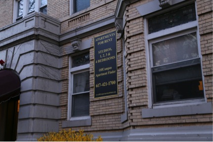
The many apartment buildings South of Boylston Street were advertised in for rent via signs by ‘OffCampusApartmentFinder.com’ service, evidence that many residents here were students, shown in Figure 4. Within walking distance are several institutions of higher education, including Northeastern University, Boston University, Massachusetts College of Pharmacy, and Simmons College. Student residents are often very transient, moving every year, and are often absent during off term months. Nearby businesses too are student focused; a neighborhood fast-food restaurant advertised its late closing hours, likely to appeal to the young residents and sporting event attendees. I am interested in observing the relationship between the site, the educational institutions, and the students and other residents who live there, likely manifested though land ownership patterns.
The area also lends itself to retail and office development, as it lies at the junction of Boylston Street and Brookline Avenue, historically key commercial streets of the region. Brookline Avenue runs at an angle relative to Brookline and streets further south of the site. This is a break in the grid pattern between these two parts of the site. Clay’s work suggests these “irregular and angular street junctions” lie where the “original gridiron … clashes with an adjoining street network.” [2] I selected my site primarily by looking at the maps, so I was keenly aware of the street layout as I went to visit the site. Boylston’s status as the transition road between the two systems was most apparent at its intersection with Brookline. The triangle-shaped lot it created was extremely visible, and a new commercial high rise had been built there. Clay describes this phenomenon: “High prices have always been paid for highly accessible sites, and the junction of two diagonal streets has been exploited for its accessibility for thousands of years.” [3] From the vantage point of the Shaw’s supermarket, I noticed the land use was almost exclusively commercial suggesting the high land costs were absorbed by these tenants for the benefit of being located on this important juncture. I observed not only constant heavy vehicle traffic, but also significant pedestrian traffic.
The complex interactions of natural, economic, and social forces that influence this site drew my interest. An analysis of these forces offer insight into the past, present, and future state of the site. Although the neighborhood seems relatively static, Clay reminds us that “it is foolish to yearn for a settled stability of scene that never existed” [4] - that even within a static appearance, there are dynamics to be explored beneath the surface.
1. Grady Clay, Close-Up: How to Read the American City (Chicago: University of Chicago Press, 1980), 39.
2. Ibid 42.
3. Ibid 50.
4. Ibid 16.
Clay, Grady. Close-Up: How to Read the American City. Chicago: University of Chicago Press, 1980.
Google Maps. Boylston Street and Brookline Ave. Last modified 2014. https://www.google.com/maps/place/Boylston+St+%26+Brookline+Ave/@42.3433164,-71.1026476,17z/data=!3m1!4b1!4m2!3m1!1s0x89e379f47d3a4683:0x7cd3160dee9c55f0