From Bourbia, F. "Impact of street design on urban microclimate." Renewable Energy (2009)
Urban Street Canyon - Heat
Heat can be uncomfortable and harmful to urban dwellers. Given its role in ozone production and thus the creation of photochemical smog, some researchers (such as Brian Stone, Jr. at Georgia Institute of Technology) have suggested that policy makers classify heat itself as a pollutant. At the same time, maximizing urban heat in cold climates or during cold seasons could make cities more energy efficient. Maximizing or mitigating urban heat requires an understanding of the urban microclimate.
Canyon Observation
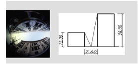
F. Bourbia’s recent study of seven canyons in Constantine City in Algeria, soon to be published in Renewable Energy, provides an example of how urban climatologists study heat in street canyons.
Bourbia, a researcher in the University of Constantine’s bioclimate and environment department, looked at 7 canyons in the densest part of Constantine City in the summer of 2007. Bourbia measured air and ground temperatures in buildings with aspect ratios ranging from 1 to 6.7 and sky view factors ranging from .076 to .58. Pictures of each canyon are available here.
From Bourbia, F. "Impact of street design on urban microclimate." Renewable Energy (2009)
Measuring both air and ground temperature is common in urban climatology, as use of just one measurement can skew results. For example, measuring only surface temperature from aircraft or via satellite will lead to many readings from horizontal surfaces, but none from vertical surfaces. This oversampling of areas directly exposed to sunlight will give higher average temperature readings than using air temperatures.
Bourbia concluded that an increase in sky view factor during the day led to higher canyon temperatures, and an increase in aspect ratio led to lower canyon temperatures. A higher ratio factor and lower sky view factor will not allow as much sunlight into the canyon, hindering its ability to heat. In a city where the average maximum summer temperature is 97 degrees Fahrenheit, these findings are important.
More generally, Bourbia states in the paper’s conclusion that such findings have direct application in urban design, “The geometry of urban canyons plays a decisive role in urban heat island mitigation . . . sky view factor is suitable to be incorporated into urban design evaluation and decision making because of its key role.”
Canyon Modeling
In a 2007 study published in Boundary Layer Meteorology, E. Scott Krayenhoff, a doctoral candidate in the geography department at the University of British Columbia, looked at street canyon heat using a 3-D energy model, called TUF-3D (Temperatures of Urban Facets in 3-D).
TUF-3D can predict urban surface temperatures over the period of days or hours for a variety of surface materials and shapes. Krayenhoff used a fairly simple model, an array of cubes, to look at how heat flows in a street canyon.
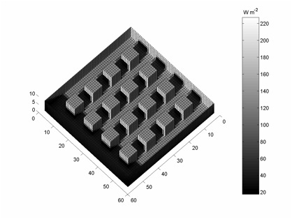
7 a.m. TUF-3D Reflected Solar Radiation. Courtesy E. S. Krayenhoff.
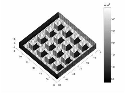
10 a.m. TUF-3D Reflected Solar Radiation. Courtesy E. S. Krayenhoff.
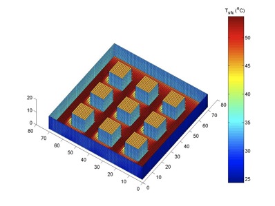
2 p.m. TUF-3D Surface Temperature. Courtesy E. S. Krayenhoff.
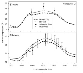
Applying his model to observations made in actual street canyons—in a industrial area in Vancouver in 1992 and others studied in 2001 as part of the larger Basel Urban Boundary Layer study (BUBBLE)—Krayenhoff found that the model conformed well to observed data.
A comparison of modeling output with canyon observations in Vancouver. From Krayenhoff, E. Scott. James Voogt. A microscale 3D urban energy balance model for studying surface temperatures. Boundary-Layer Meteorology (2007)
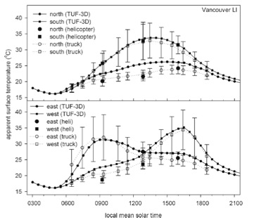
A comparison of modeling output with canyon observations in Vancouver. From Krayenhoff, E. Scott. James Voogt. A microscale 3D urban energy balance model for studying surface temperatures. Boundary-Layer Meteorology (2007)
Though an array of cubes may seem overly simple, Krayenhoff stresses that researchers attempt to model the complexities of process (like heat exchange) instead of complexities of a single canyon's structure. Such models are key for generating general theories in the field.
An example of a process the field now grapples with is heat transfer through chaotic exchanges like turbulence. The models themselves are also growing increasingly nuanced. For example, models of building sides have changed from flat panels to rough surfaces. “For a while a surface was seen as one structure,” Krayenhoff said. “The latest suite of models says the urban surface is really 3D and that affects the heat and surface area in contact with atmosphere. That’s a big change in the past 10 years.”
Regarding the complexity in such models, Oke agrees with Kraynehoff: “It’s a matter of balance between too basic a set of principles that don’t have any applicability in the real world and over complexity which drowns you . . .You have to float along in the middle somewhere. Some of that comes from the applied fields [such as architecture and urban planning] in determining what’s important and what’s not.”
Krayenhoff believes the field of urban climatology as a whole has general prescriptions for applied fields. “Certainly there are recommendations that can be made and that have been made already. Though that’s one of the big disconnects that our field needs to work on: the fact that urban planners and designers, for the large part, don’t pay a lot of attention to the climatic effects of how they build or how they design.”
He sees this relationship is already changing. “With fossil fuels becoming more expensive and concerns about climate change, interest in building more energy efficient neighborhoods is growing."