Stand under the Chinatown Gate and look up--a small brick building is surrounded by the State Street skyscraper and a new apartment development, currently under construction, all framed by the intricate details of the token symbol of Chinatown. Each piece of this picture comes from a different time period, each one a result of different forces acting on the area, clues that help puzzle together the story of a particular site. These clues in the city expand on the story told in “Site Through Time”, the parts that could not be seen by simply examining maps.
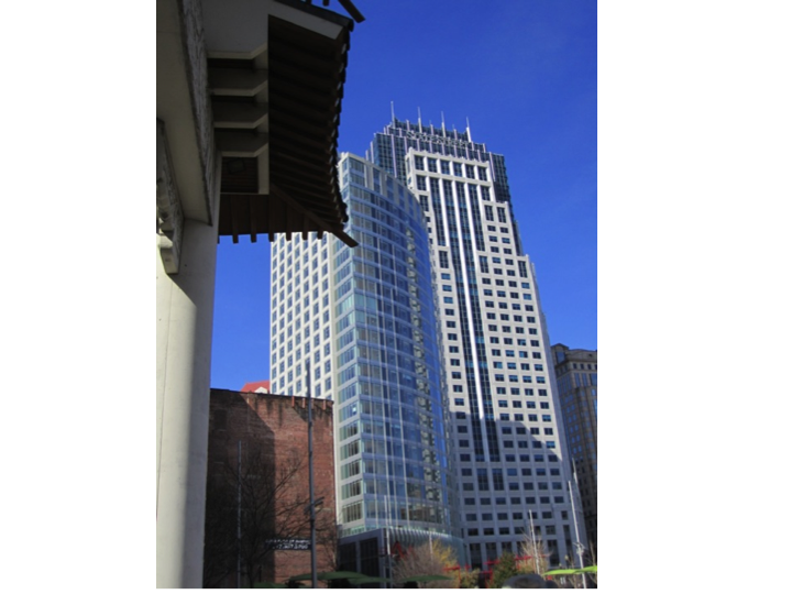 Figure 1:Picture taken from the Chinatown Gate. Note the different layers of Chinatown seen in this photo—the iconic gate, a small brick building, a new apartment complex, and the State Street skyscraper.
My particular site is composed of the eastern half of Chinatown and extends further east until South Station. In the present day, as you move from north to south through my site, there is a spectrum from commercial to residential buildings. The site is bordered by the financial district to the north and contains a portion of Tufts Medical Center on the west side, supporting a wide variety of land uses. When walking through present-day Chinatown, the surrounding cityscape can be broken down into layers, each layer describing a different phenomenon or era.
The Original Chinatown:
The majority of present-day Chinatown is still, at its base, composed of three to four story brick row houses. Stripping away all additions and renovations, one can see that the original brick row houses have the same footprint as the ones drawn on the 1867 Sanborn fire insurance map. The unaltered footprint along with the weathered, faded brick leads me to conclude that these are the same structures that stood in the mid 1800’s. Moreover, although the street-facing row houses have been renovated, the sections on the inner sides of blocks have not been changed as much, leaving a better picture of Chinatown in the mid 19th century and gives a reference to compare the amount of change that has occurred since then.
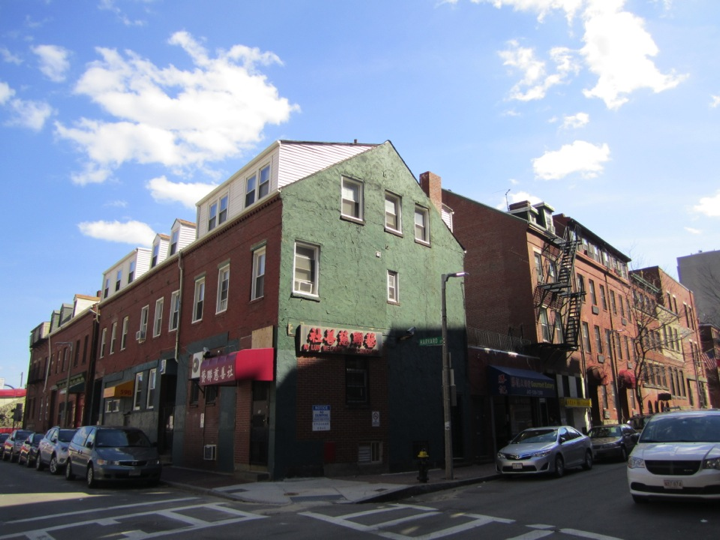 Figure 2: These brick row houses can be found all around Chinatown. They match the footprint of the Sanborn maps from 1867 leading me to believe they have not been changed since then.
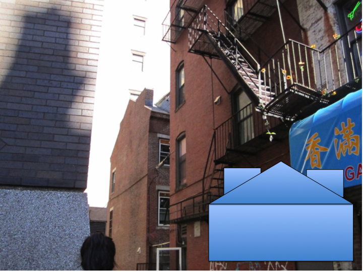 Figure 3: Notice the shape of the roof on the building in the back (highlighted by diagram) from the 1800’s. The building is hidden from the street and is therefore has not been altered or renovated as much as the building in front. This roof structure can be seen across my site.
Fast forward a short amount of time, and we see tenement buildings on the Sanborn maps--densely packed residential units on the inside of blocks with much lower living conditions. Today, some of these areas still exist--Figure *** shows the back entrances to many cramped living quarters. Although the area looks like the back of stores and restaurants with all the pipes, there are people entering and leaving doors on the right side which lead to residential spaces.
In that time period, the tenement housing was used by workers in the nearby stores and restaurants, but also in the nearby industry. Walking around my site, I found a plaque marking the area as a “National Register District” because of the leather industry which had previously inhabited the area (figure ***). In the 1800’s, the leather district in Boston was located to the east of my site, creeping into the panhandle portion, until it disappeared completely from the maps. The industry can no longer be found in the area, except for the plaque and the Boston Hide & Leather Co. Inc. offices located a couple streets away, the rest replaced by other commercial uses and office space.
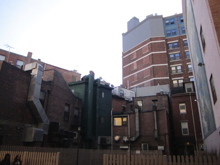 Figure 4 : On the 1800 Sanborn maps, tenement housing used to stand here. Today, this area is still filled with low-income, densely packed residential units. From the back, it looks like the back of many restaurants or shops but people enter and leave the gate to enter their homes on the inside.
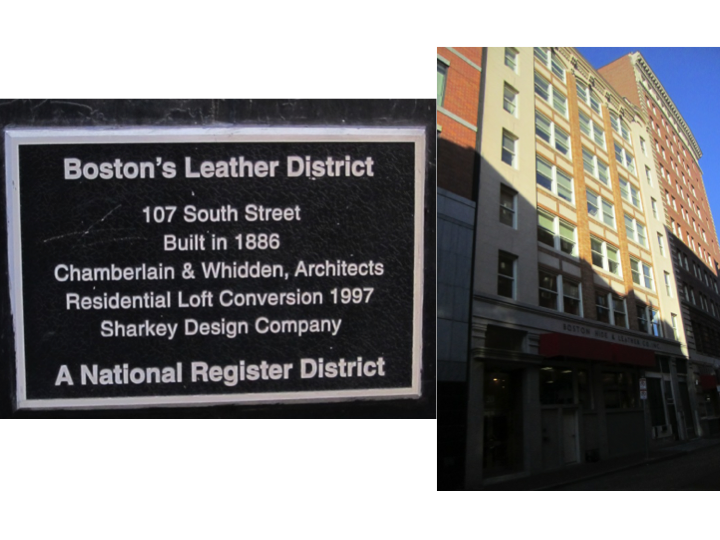 Figure 5 : All that remains of Boston’s Leather District is a plaque and the Boston Leather and Hide Co. Inc. which looks more like office buildings than industry space.
Changes to the Original Structure:
Looking at the row houses, most are relatively the same height, minus the additions, until we reach the street corners where there are often seven to eight story buildings. This pattern repeats on several other streets--where a row house is suddenly replaced by this much taller building. In the early 1900’s, the garment district moved into the site. These larger buildings were erected for the garment industry--they are taller with large windows so that the seamstresses could see. Today, these still stand, used for office space or residencies. Interestingly, the ground floors of these larger buildings are also less commonly transformed into a store fronts.
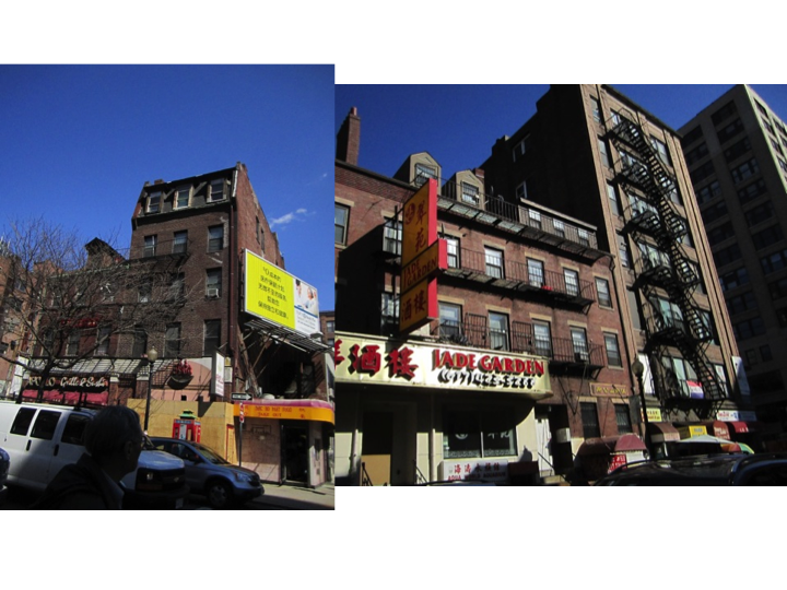 Figure 6: The pictures above show two instances where the pattern of three story brick row houses is broken by a much taller building. These buildings could have been used to house the garment district seamstresses. They stand taller and have large windows because light was needed for the work.
The majority of buildings in Chinatown, even the more residential areas, have store fronts on the ground floors and residential units up above. When looking at these buildings, it is almost difficult to imagine their original brick form. Facades have been added in different materials and additions stand above the base structure. But at closer inspection, almost all of the backs of the buildings are still made of weathered brick. Renovating shop fronts and only street-facing surfaces may reflect a lack of money by the general population in the area. In addition, Professor Tunney Lee commented that the tattered, almost grimy feel of Chinatown keeps other groups from trying to buy into the area, thus protecting the identity of a population.
The Introduction of Automobiles:
Comparing the maps throughout the years, a significant change that is first seen in the 1951 map is the widening of Kneeland Street. Kneeland Street, which cuts horizontally across my site, was widened which means buildings were either demolished or they were pushed back. Looking at the present day site, it seems as if the buildings along Kneeland Street look a bit too narrow. By closer inspection, there is a slight color difference in the brick on the faces of some of these buildings. This leads to hint that parts of these buildings had been shaved off and a new faces were slapped on. In many cases, it looks as if the original face had been saved to re-adhere to the side of the buildings. The widening of the streets were probably brought about by the popularization of the automobile, especially as this change occurred in the early 1900’s.
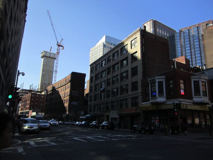 Figure 7: Kneeland Street was expanded in 1836, according to Professor Tunney Lee. The large buildings on this street look a bit disproportionally narrow. In addition, you can tell that the building on the right has a façade that is made of a white material as opposed to the brick. These older buildings juxtaposed with the crane and new highway structure in the background show two different time periods acting on the same area.
Continuing the trend of automobilization in the area, the mid 1900’s also brought about many parking lots. In my site, there are many parking lots and garages which have taken the places row house units. There are buildings on both sides of the parking lots and on the buildings, there are often times signs of the previously standing row houses. I hypothesize that the buildings that were torn down were residential and from the 19th century because the roofs resemble the shape of the buildings previously described with the double chimney roofs. Many of these areas were inhabited by low-income workers, based on the high density of this housing surrounded by the railroad systems. Slum-like areas were cleared out in the mid to late 1900’s, meaning many of the tenement houses and many of the residential areas were replaced.
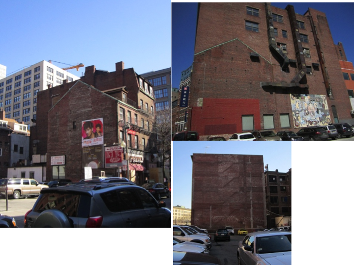 Figure 8: The pictures above are two examples of row houses that have been cleared out for parking space. The outlines of the roofs of the buildings that were torn down can still be seen, left on the side of the brick.
As I’d pointed out in the previous assignments, the biggest change when observing my site through time using maps, is the addition of the Expressway along the eastern border. What used to be railways has now been replaced by a highway running north and south through Boston. The highway itself is an artifact of urban renewal and the Highway Acts of the mid 20th century; specifically, the government replaced parts of the city, residential areas of Chinatown included, in order to build I-93.
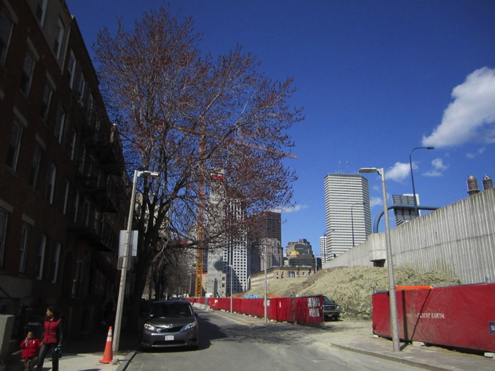 Figure 9: The Expressway is juxtaposed against the brick row houses from the 1800’s.
The Future of Chinatown: Battling Tensions
When walking down the street in Chinatown, especially the more commercial streets, you can tell that you are in a place with a particular cultural background. Not only are there signs with both Chinese and English, but there are architectural details on buildings that reflect the Chinese population. Buildings are built with arched roofs and columns, statues of Chinese figures stand outside doorways, and Chinese paintings don the walls of buildings. This can be seen as a way for this population to express itself and to establish its own identity in the area they recognize as their own, especially given the flow of immigrants through the area before the Chinese came.
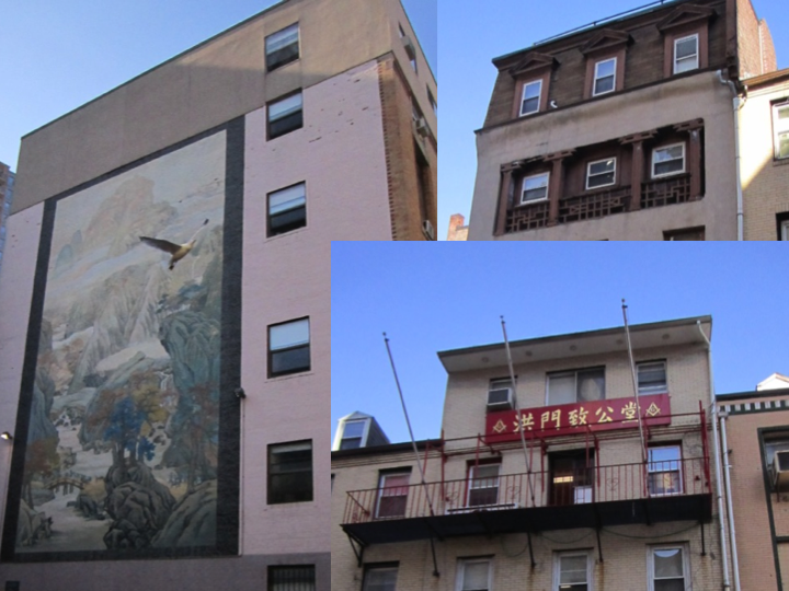 Figure 10: The picture above are a few examples of the details in architecture and design that reflect Chinese architecture styles and tradition in a subtle manner.
However, when these details can be attributed to the inhabitants of Chinatown, there are other details that seem to be more forced. On the busier streets of Chinatown, the streetlights are donned with small pagoda roofs as are the telephone booths. The Merchant’s Association Building is also topped with a pagoda along with the words “Welcome to Chinatown” in the font that is typically associated with Chinese take-out restaurants. Even more shockingly, the Chinese Merchants’ Association Building is still marked as such by the Chinese characters on the top of the building but is no longer used for that purpose--the building is now advertised as a karaoke joint and a massage therapy clinic. According to Professor Tunney Lee, this is actually a front for a brothel which, in itself, is perhaps a trace of the Combat Zone that once inhabited Chinatown. In addition, where Chinatown and the Rose Kennedy Greenway cross, bamboo groves have been planted. These details, although they also reflect Chinese culture, seem more exaggerated, with their bright colors and almost cartoonish style. They depict a different Chinatown--a caricature of Chinese culture as opposed to the home of the Chinese population.
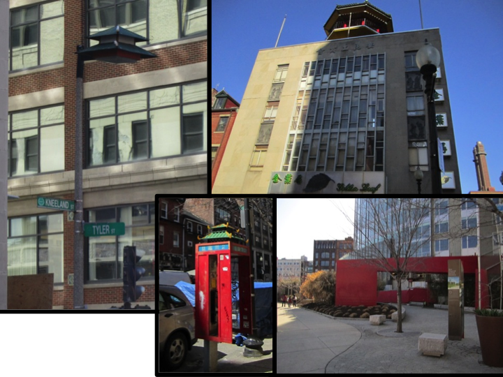 Figure 11: Many of the Chinese “symbols” in Chinatown are more caricatures than a true representation of Chinese culture. Starting from the top left, what used to be the Chinese Merchants’ Association Building still is named that (Chinese words along the top) but now has a pagoda on its roof. In the top left corner, a street has donned a pagoda also. Moving counter-clockwise, a telephone booth has had similar additions added to it. Finally, in the bottom right hand corner, bamboo groves (circled in red) were recently added where the Rose Kennedy Greenway intersects the edge of Chinatown.
The difference between the two types of details perhaps lie in their intention. While the previous celebrates an internal culture, the latter might have been put in place for the outsiders, to attract tourists, and to tell the visitors that this is a place with an immense amount of culture, and to somewhat play into the conventions people associate with Chinese culture for monetary gain. Whatever the purpose of these details may be, the emergence and the influence Chinese culture has had on this site can not be seen through maps but is undeniably prominent when visiting the sight in person. These details also reflect the values of the population--that culture and identity is highly important.
Walking through my site, it is also impossible to ignore the number of cranes you can see in both the site and the surrounding areas. Cranes are a symbol of construction and new development. Perhaps they are not an article of the past but they do represent a general trend for the future. In particular, there are several housing units being renovated and built. The Hong Lok House on Essex Street, which is currently under construction, is being renovated as a low-income housing units. On the other hand, there is a large apartment complex being built on the corner of Essex Street and Edinborough Street under the agreement that the developers also provide a certain amount of lower income housing. Although there is not much room for Chinatown to expand, it does not seem that Chinatown is losing ground either and there are efforts to upgrade the existing structures, often by building up.
Not only do large corporations come in and try to gentrify the neighborhood, so is the city as well as the inhabitants. For example, the brick row houses are often renovated with new faces. The remainder of the houses are still made of the standing weathered brick but there are much more modern renovations to the store fronts. These store front have been renovated continuously through time giving a variety of building material and styles--one of the most distinct is a printing shop which was renovated in the style of the 1920’s.
So there is a dilemma: outsiders entering the area means that the essence of the Chinese culture is being replaced by newer but cartoonized versions. The new additions are renovations, improving the standard of living of the population, but they are also not a reflection of the people themselves, but rather a caricature for the sake of tourism or other outsiders. Is the intrusion of outsiders a positive force or a negative force? Will they continue to develop, encroaching on the area known as Chinatown or will the proponents for the preservation of Chinese culture put an end to this?
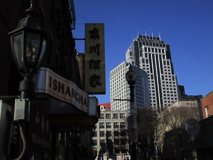 Figure 12: Chinatown is, and will continue to be, a place where the traditional and the new battle for control.
From my own experiences, I know that the Chinese population is spreading. Living in the suburbs of Boston on the South Shore, I have watched the Chinese population in Boston slowly travel further and further south, growing quickly in towns such as Quincy and even in my hometown, Braintree. As the suburban Chinese population grows, I initially wondered whether this would mean a decrease in the Chinese population in Chinatown and cause a decline. However, the steady stream of immigrants coming from mainland China will continue to supply a population whose center will remain in Chinatown. These factors will determine the future of area as well as a population and culture, making this an indisputable center of change in the coming years.