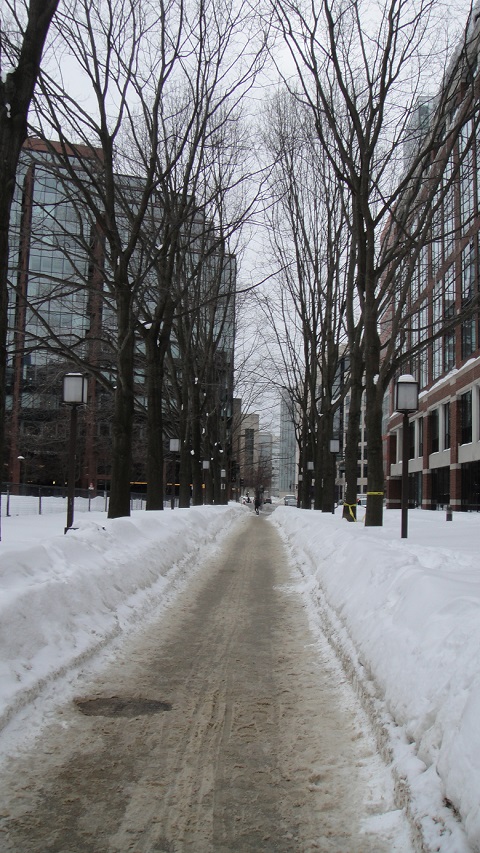
 Image from the midsection of Pedestrian Walk in the winter. In the background, tall, reflective buildings can be seen. Image by author.
Walking through Kendall Square, one can immediately discerns its urban features; tall buildings built with reflective metals and glasses, the abundance of car traffic as well as the pervasiveness of asphalt everywhere - distinctive marks of a “granite garden” (Spirn, 1947). Continuing north from Kendall Square’s northern boundary, one notices a small anomaly in the urban environment: a pedestrian pathway that is lined with shady trees that are home to squirrels and hares, green expanses of grass and colourful bushes. It is an anomaly, not because nature in an urban environment is an anomaly, but because more nature is present here than the rest of my site combined. It is however, partially thanks to this fact that Pedestrian Walk is favoured over other walkways in the area, and sees huge amounts of pedestrian traffic daily. Nature, as well as the history of streets on this site, have encouraged the use of this pedestrian pathway.
Layout of Pedestrian Walk
One of the reasons why Pedestrian Walk is popularly used is its strategic location that almost linearly connects Sixth Street and Ames Street. A study of old maps reveal the history behind the layout of Pedestrian Walk. North of the pathway is a residential area that has existed since the 1850s. An old map by H.F. Walling depicting the City of Cambridge in 1854, shown in Figure 1a below, outlines the residential area, which directly borders fields to its south. The fields were eventually cleared away to make space for industrial and institutional buildings, such as the Cambridge Police station, an AT&T communications tower, and office spaces. However, existing streets from 1854 were not demolished; they were extended to meet larger streets such as Broadway to the south. In Figure 1b, a portion of the Sanford maps from 1900 shows that Sixth Street stretched so much as to meet Main Street, intersecting with Broadway and Broadway Canal. It is now evident that Pedestrian Walk used to be part of the elongated Sixth Street. Sixth Street may have been shortened shy of Binney Street to accommodate for Binney Street’s medial strip, with the intention of making the intersection two-way, instead of four-way. The medial strip separates traffic directions, such that vehicles are unable to cross Binney Street, only along Binney Street in one direction. Pedestrians are however, able to cross Binney Street using a pedestrian crossing located right at the northern exit of Pedestrian Walk.
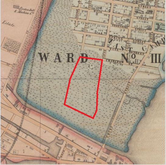 Figure 1a: Closeup map of my site in 1854. At this time, it is completely covered by the field. The red polygon marks the approximate borders of my site. Map by H.F. Walling, Civil Engineer for the City of Cambridge.
 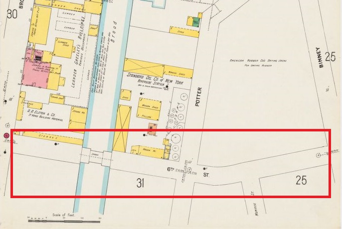 Figure 1b: Sixth Street was extended to Main Street in 1900. Sixth Street was later shortened to just short of Binney Street. The red rectangle marks the portion of Sixth Street that was converted to Pedestrian Walk. Image from Sanborn Fire Insurance Maps, 1900.
Pedestrian Walk is surely a product of urban landscaping. The trees are planted at regular intervals from each other, in a predictable and uniform fashion. Moreover, benches are placed, also at regular intervals from each other, and the bushes planted only at specific locations. The walkway itself is paved with concrete blocks that are similar to pavements that were constructed post-1950.
Microclimate
With the construction of concrete and glass-heavy buildings in the southern part of my site, the climate of my site have changed drastically from the field-derived climate of 1854 to a more “urban heat island”-esque climate today. Although it is unclear what sort of fields were on my site in 1854, the replacement of the fields with buildings, pavements and roads have undoubtedly added to the heat island effect. “Concrete, stone, brick and asphalt [absorb] heat” in larger quantities than plants do (Spirn, 1954). In addition, two parking lots have been constructed on my site, approximately 2 blocks apart. The parking lots, like most other parking lots, have asphalt surfaces, and have been cleared out, leaving a mostly flat surface. These characteristics usually contribute to little to no wind dampening across these lots, and hotter temperatures as heat is reflected across the asphalt and the tall glass buildings nearby. Some attempt has been made to plant trees along these lots and buildings, but the “teacup syndrome” prevents these plants from flourishing. A combination of “air pollution, paved ground surface, and compacted, infertile soil” keeps the street trees “frozen in [juvenile form]” (Spirn, 1954). These trees do not grow sufficiently to affect the microclimate of their surroundings in a significant manner. One observes trees that do well, the closer one gets to Pedestrian Walk.
The microclimate of the pedestrian walkway is more pleasant to the human body in comparison to its neighbouring areas. The trees on the walkway have thrived, thanks to multiple factors, to effectively create a microclimate that is appealing to people. What was previously Sixth Street was not thinned down, it occupies approximately the same space it used to. The walkway itself is approximately half the width of the existing street. The other half is taken up by spans of grass and soil. In addition, the Volpe National Transportation Systems Center, like other federal buildings, has large landscapes of land that borders half of Pedestrian Walk. While a fence separates the walkway from the federal land, the barrier is only from the surface of the earth. The trees that grow along the walkway essentially have access to the landscaped land beyond the barrier. The large expanse of soil the trees are given provide nutrients and space for the trees to flourish; and flourish, they did. Furthermore, the Sanford maps show that part of Pedestrian Walk was built over Broadway Canal. Broadway Canal does not exist anymore, but it is not unfeasible to think that the soil near what used to be Broadway Canal is more fertile as the water carries minerals and soils from other areas and deposits it by the banks. Although less likely, it could be that the canal is now underground, and provides irrigation for the trees and plants living above it. Both facts could explain why the trees that grow on Pedestrian Walk is doing so well. As a result, a microclimate is created on this walkway. The leafy trees provide shade to pedestrians, away from the relentless glare of the sun. The trees and the tall building flanking the walkway also provide shielding from the chilly wind. The shrubs help keep the air in the area clean.
In contrast, two other different walkways on the other side of Biogen Idec have climates that are more similar to the surrounding urban climate. The pathways are vehicle-friendly, which means that they are paved with asphalt, with raised pavements for pedestrians. In addition, the walkways are flanked with car garages and factories, which has an impact on air quality that will be elaborated upon later. Trees are indeed planted along these roads, but do not flourish for they are victim to the “teacup syndrome”. As a result, there isn’t much shade to speak of; the walkways are inundated with typical urban materials such as asphalt and concrete.
Air Quality and Movement
In The Granite Garden, much emphasis was laid on air quality and the inevitable pollution that came with urbanization. Boston, by virtue of being close to the Atlantic Ocean, experienced sea breezes that made it less predisposed to inversions compared to other landlocked cities (Spirn, 1954). While Boston does in general have better air quality indices than most other landlocked cities in the US , air quality in specific areas could vary according to its surroundings. My site covers many streets, of which Binney and Broadway are particularly busy. In addition, the industrial buildings in the area does some manufacturing work that ostensibly emits pollutants into the air. Regardless of the purpose of shortening Sixth Street, the effect of Pedestrian Walk not being open to vehicle traffic meant that there was better air quality along Pedestrian Walk. Furthermore, trees are known to improve air quality; “leaves and twigs of trees and shrubs filter out dust from the air” (Spirn, 1954). Despite a lack of air movement along Pedestrian Walk, the air quality remains qualitatively good. Wind rosette for Boston , seen in Figure 3, showed that wind direction distribution was least in the north-south direction, and most dominant in the west-northwest and east-northeast directions. Broadway is angled at almost exactly the west-northwest and east-northeast directions, making it a prime channel for winds blowing at this angle. In addition, Broadway has a long stretch of straight road, about a mile long that is connected to Massachusetts Avenue at a gentle angle. Wind tended to blow down Massachusetts Avenue and into Broadway in great amounts, and undampened in a wind channel attributed to the long stretch of unbroken road. The wind does not tend to break off north off Broadway into any of the walkways on my site.
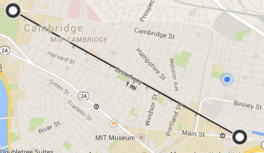 Figure 2: Broadway stretches for an unbroken mile in the East-Southeast direction. Image from Google Maps.
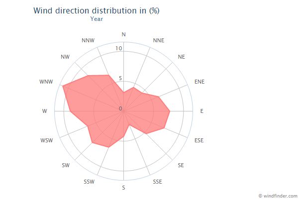 Figure 3: The wind rosette for Boston throughout the year. Wind direction distribution is skewed in the WNW-ESE directions. Data collected from Boston Logan Airport, accessed through windfinder.com .
The road design and location near Pedestrian Walk contributes to its relative good air quality. Traffic on either ends of Pedestrian Walk tended to be of the fast-moving kind, with few cars idling at any time. The lack of intermittent traffic lights on the intersection of Binney and Sixth allows for fast movement of cars and prevents traffic bottlenecks . As for the intersection of Broadway and Ames Street, it is probably the case that multiple traffic lights along Broadway disperses traffic distribution, such that the number of vehicles at any given traffic stop is limited. In any case, the sparse amount of idling traffic near the exits of Pedestrian Walk contributes to the air quality there. In addition, while Biogen Idec is next to the walkway, it does not produce much pollutant to speak of, by virtue of being a research facility, rather than a manufacturing facility. Air movement is relatively minimal, compared to the winds on Broadway, making Pedestrian Walk prime location for taking shelter from the wind. In addition, Pedestrian Walk is slightly curved so it further dampens any wind. Furthermore, the dampening ability of Pedestrian Walk is not limited to chilly wind; Pedestrian Walk is also consequently protected from strong winter storms.
Cambridge Center and its neighbouring pathway, on the other hand sees much worse air quality because of the sheer number of idling vehicles in its vicinity. Multiple vehicles idle outside the buildings’ main entrances, as well as the entrances to the parking garages. The lack of vegetation does not help with the air quality. These pathways are oriented in the same approximate direction as Pedestrian Walk, so it does not see much wind either. In this case, however, this results in a worsened air quality level, as the pollutants from the car exhaust tended to linger and is not blown away by wind.
AestheticTied very closely with the flourishing vegetation and life on Pedestrian Walk, the aesthetic of Pedestrian Walk is pleasing to the eye. It is not unthinkable to imagine that some pedestrians choose to traverse along this walkway because it is beautiful and aesthetically pleasant to look at. The beauty of Pedestrian Walk can yet again be attributed to the vegetation and life that blossoms on this walkway. In the summer, the lushful green is a welcome break from the relentless glare of the sun. In the fall, the presence of a steam vent by the side of Pedestrian Walk creates a gradient of temperature across bushes and trees, curiously creating, in turn, a colour gradient of autumn leaves that line Pedestrian Walk. During the fall season, it is not uncommon to observe tourists venturing here to photograph the autumn leaves. In the winter, the snow, in combination with the bare trees, creates an iconic winter image. The urban pedestrian is not immune to the charms of nature, and is perhaps all the more attracted to it by virtue of living in an urban environment that is sparing in nature.
On any given day, Pedestrian Walk sees at least two hundred pedestrians. Even during the winter, when it is cold, and people are less likely to favour walking, Pedestrian Walk is still much frequented. Most of Pedestrian Walk’s appeal can be attributed to the trees and shrubs that flourish there and their derivative effects thereof, but the history of the site on which Pedestrian Walk was built on cannot be discounted to have had no effect. In fact, Pedestrian Walk might have been selectively landscaped as such due to its popularity amongst pedestrians before such a walkway existed.
Bibliography: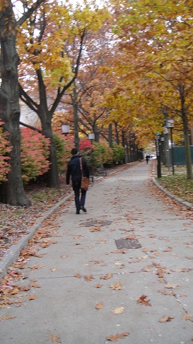 A picture of the trees and bushes along Pedestrian Walk in the fall season. Image by author.
1. Spirn, A., The Granite Garden: Urban Nature and Human Design. New York: Basic Books, 1984.
2. Krieger, A., Cobb, D., Mapping Boston, Cambridge: The MIT Press, 2001.
3. Sanborn Fire Insurance Maps, 1867-1970 – Cambridge, MA.
4. EPA Air Quality System, Air Quality Index, 2015. Accessed on www.airnow.gov.
5. Wind and Weather Statistics, Boston Logan Airport, 2014. Accessed on www.windfinder.com.