Today, East Cambridge is an area with a compatible unity of residential, institutional, commercial and industrial spaces. The amicable coexistence between these four different uses of the space can be attributed to the gradual development of land in East Cambridge. Political, economic and cultural processes have peppered the history of my site and steered later developments on my site to complement existing land uses. The development of East Cambridge was not so much in layers as in sections. The land use on specific areas on my site, as well as in its vicinity has largely remained unchanged even through the years; the residential area has remained residential while an industrial area grew south of it, and a commercial area grew south of the industrial area. While not immediately obvious to the layperson on the site, there exists traces and artifacts on the site that hint at these processes. When closely read, these traces and trends can serve as puzzle pieces that can be put together to predict the future fate and nature of East Cambridge, particularly in regard with the price of land in the area.
Residential Grid
A large portion of East Cambridge is residential land, set in a grid. The current grid in East Cambridge is a very real artifact that has been known to exist since 1854. H.F. Walling’s 1854 Map of Cambridge shows the grid in its original form, stretching from Craigie Street to Charles Street from north to south, and 1st to 6th Street from east to west. As the first real development in East Cambridge, the creation of the residential grid was largely a speculative venture by the very same investors that funded the construction of Craigie Bridge . Craigie Bridge, more commonly known as the Charles River Dam Bridge or the Canal Bridge, is a bascule bridge that connects East Cambridge to Boston. The residential area that was built here was meant to house people who worked in Boston, with Craigie Bridge acting as the main means of transport for these workers to commute to Boston. Much like other areas close to Boston , East Cambridge started out as a textbook manifestation of a suburb to Boston.
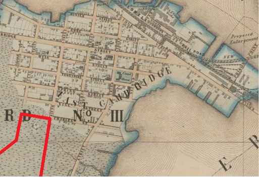 Figure 1 Map of East Cambridge in 1854. My site is delineated in red and can only be seen partially on this map. When the marshlands were filled in, development of the land followed the grid closely. 4th Street was not elongated because 3rd Street is not linear and left little to no space for it to elongate.
 In later years, the land south and west of the grid was developed to house factories and various industries. Roads from the original grid were extended to the newly filled land. 1st Street through 6th Street were extended, with new streets created to line up with the grid to 9th Street and beyond. 4th Street was not extended because the winding of 3rd Street to the west left little room for a street extension. It would not have made sense for two roads to be too close to each other, leaving little space in between for buildings. Similarly, new east-west streets were constructed south of the original end of the grid, Charles Street. The roads on my site today are mostly extensions of the grid that was created in the 1840s. The grid currently breaks at Binney Street, a rather new development that occurred in 1993, when part of 5th Street was removed, and 6th Street was turned to a pedestrian pathway. Prior to that, the grid extended to Broadway. Broadway’s popularity and long history made it difficult for the grid to extend beyond it. The filled marshlands to the south were then mostly populated with industrial and institutional buildings between 1903 and 1950.
The filled marshlands to the west were mostly developed as residential areas, with a smattering of commercial spaces on major streets and several institutional buildings. However, the amount of land that could be developed to the west was limited. Another residential area was already in place west of the marshlands. Today, the entire area is fully developed with housing. The capacity of the residential area is limited, and is part of the reason why the prices of land and housing are rising. It is safe to assume that the prices of housing will continue to rise as more companies and industries move in south of East Cambridge. The increase in housing demand cannot be met with the limited supply in East Cambridge.
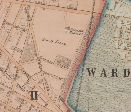 Figure 2 Map of East Cambridge in 1854. There is little space to develop between the original grid and the residential area west. Binney Estate was divided up and new streets were constructed in alignment with the grid.
 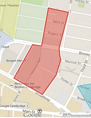 Figure 3 A current map of East Cambridge. My site is delineated by the red polygon. The area south of Charles Street, including Bent Street and Rogers Street are later additions to the grid. Development of land south of the original residential area is very much influenced by the existing grid.
 In the 1960s, NASA bought fourteen sites in East Cambridge for its Electronics Research Center (ERC). Several artifacts and traces remain from this decision, although the ERC has long since closed. The advent of the Space Race catalyzed the establishment of the National Aeronautics and Space Administration (NASA) in 1958. Soviet astronaut Yuri Gagarin’s successful flight to space in 1961 led to fears of the United States falling behind in the Space Race . The then President of the United States, John F. Kennedy, signed into effect efforts to boost NASA’s programs in a bid to catch up to the Soviet Union’s space success. Multiple sites were chosen for new NASA buildings, one of them East Cambridge. The decision to base a few NASA buildings in East Cambridge was not surprising, considering its close proximity to the Massachusetts Institute of Technology (MIT). Being close to MIT would have allowed for research collaboration between MIT and NASA. In addition, the president had ties to MIT. Jerome Wiesner of MIT was science advisor to both President Eisenhower and President Kennedy. President Kennedy’s roots in Brookline, MA, just a few miles away from MIT, may also have influenced the selection of a site in Massachusetts.
NASA’s plans to place a major center in East Cambridge created ripples throughout the community. The site was offered to NASA under the banner of urban renewal; the few businesses that were previously in the area were bought out, turning the area less commercial and industrial in the following years. An AT&T tower was built a little north of NASA’s proposed site, presumably in preparation to support NASA operations in East Cambridge. The tower remains in East Cambridge to this day, an artifact and a trace of NASA’s plans for the ERC in East Cambridge. The wireless tower continues to operate and provide cellphone signal coverage for the area. The excellent cellphone signal in East Cambridge could be said to be a trace of NASA’s temporary presence here. The wireless signal tower is a prime candidate to be bought out; it is located rather strategically close to Kendall Square, and wireless towers are not typically situated in areas with high rents and prices. In addition, the wireless tower also owns the large parking lot adjacent to the building.
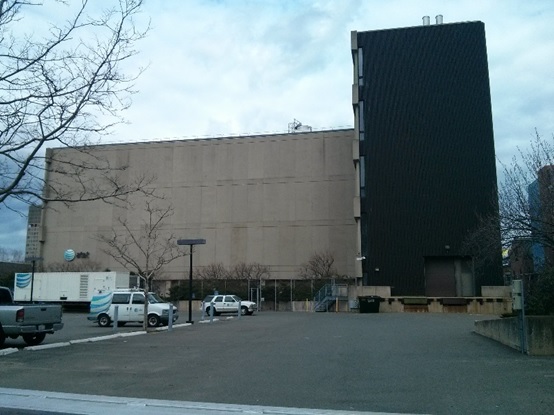 Figure 4 AT&T’s wireless tower and office building in East Cambridge. The tower is half a block away from the western boundary of my site. It was built to support NASA operations in East Cambridge.
 The decision to base NASA’s ERC in East Cambridge, along with the political controversy that led to the closure of the ERC, has had a rather significant effect on shaping the nature of East Cambridge. NASA bought out 14 land plots; the businesses and factories that were previously on the sites had to move away. The dilution of industry and commercial buildings on the site was a small-scale manifestation of urban renewal. At the time of Congress’ decision to shut down NASA’s ERC, only 6 out of 14 constructions had been completed on the purchased land plots; however, all of the land plots had been cleared of their previous constructions. The land plots remained as vacant land. In addition, the land plots purchased were large in size, in accordance to the tendency of federal agencies to have large landscaped spaces around secure buildings.
The completed NASA buildings were not torn down following the decision to close NASA’s center in East Cambridge. The ownership and occupancy of several of the buildings was transferred to the United States Department of Transportation (U.S. DOT). These buildings still remain in East Cambridge, in prime locations. As the price of land continues to soar in East Cambridge, it is not unreasonable to expect the U.S. DOT to sell the land and relocate.
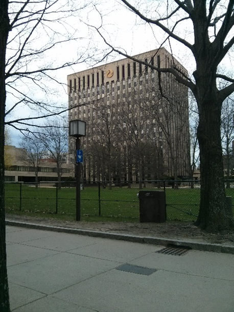 Figure 5 The original NASA Electronic Research Center (ERC) Central Building. It is now occupied by the U.S. Department of Transportation as a systems research center. Vast landscaped land is seen to border the building.
 The rise of Startups
The influx of vacant lots drove down the price of rent and space in East Cambridge. This shift occurred at a time when the price of land was increasing around MIT. It is likely that the low rent and land prices encouraged startups to choose to be located in East Cambridge, where they could still be close to MIT. In the 1990s, new discoveries and findings in technology and biotechnology drove the founding of startups out of colleges. The startups were managed by professors at MIT, and students who were still in college, or had just graduated. The companies were doing well at lower scales, but professors and fresh graduates lacked the business acumen and experience to expand the companies and scale their businesses up. Most of these startups were subsequently bought by huge, international corporations, such as Novartis, GlaxoSmithKline and Akamai. As opposed to moving the sites of the companies away to be closer to the headquarters, many of these international corporations decide to establish bases in East Cambridge.
The decision of companies to remain in the area and expand their operations here triggered a domino effect of making East Cambridge more attractive to companies that were in the same industries. Other biotechnology companies, such as Biogen Idec and Sanofi, started moving into the area. Similar trends were noted in the technology sector; Google, Facebook and Apple also set up office spaces in East Cambridge. Today, Kendall Square is a biotechnology and technology hub. East Cambridge will most likely continue to attract biotechnology and technology companies, a trend that was in part caused by NASA’s upheaval in the area. Consequently, the price of land in East Cambridge will only continue to rise.
Conclusion
The paper highlights how several key decisions in history have affected the development of East Cambridge, to make it what it is today. These decisions are still visible in the presence of traces which they left and which are part of the urban environment in East Cambridge today. The investors of Craigie Bridge could hardly have foreseen how the residential grid they funded in the 19th century would expand and affect the entire layout of East Cambridge more than a century later, and foreseeably in the future. Similarly, it would have been difficult to imagine that NASA’s leaving East Cambridge would set it up to be a biotechnology and technology hub. These decisions still manifest on my site, years after they were made, in the form of traces and artifacts.
Bibliography:• Dearborn, Nathaniel S. (1822). "A new & complete map of the city of Boston, with part of Charlestown, Cambridge & Roxbury". Retrieved 2012-01-07.
• Jackson, Kenneth T. (1985). Crabgrass Frontier: The Suburbanization of the United States. New York: Oxford University Press. ISBN 0-19-504983-7.
• Andrew J. Butrica. “The Electronics Research Center: NASA’S Little Known Venture into Aerospace Electronics”. The American Institute of Aeronautics and Astronautics, Inc. AIAA 2002-1138.
• Galloway, Eilene, "Sputnik and the Creation of NASA: A Personal Perspective," in NASA: 50 Years of Exploration and Discovery (Faircount, 2008), pp. 48-49.
Unless otherwise stated, all pictures were taken by the author.