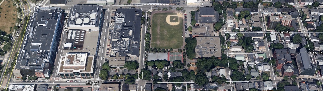
 Figure 1- This image shows a Google Earth bird's-eye view of my site, located in the Northeast part of Cambridge
I selected my site chiefly because of the array of questions that it raised in my mind as I toured the outskirts of MIT and Cambridge. My site is a 1 by 7 block area situated near the north of the assigned plot, and bordered on its two long sides by Fulkerson Street and 6th Street, and on its short sides by Binney Street and Otis Street (shown in Figure 2 below). I find it natural to categorize my questions about the site into three categories, which center on the land use diversity, historic development, and social composition that have shaped this small section of Cambridge. Most of all, with the diversity apparent from only a surface reading of this part of the city, I wonder how effectively this plot serves as a microcosm of the impact that MIT has had on Cambridge with the history of its relocation.
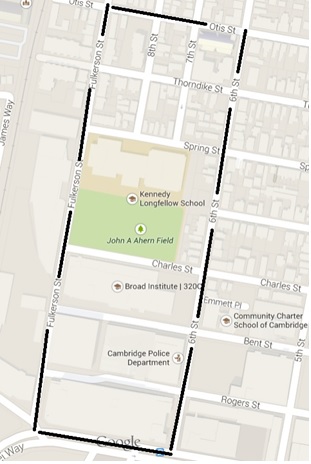 Figure 2- This shows a Google Maps view of the site with the boundaries indicated by the black lines
Walking north on Fulkerson Street (or 6th Street) there is an apparent “gradient” of different types of land usage as the types of buildings change progressively and consistently over the length of the walk. The first three blocks contain two Broad Institute buildings and also the Ironwood Pharmaceuticals building, along with the Cambridge Police Department. These three blocks have high buildings with brick or baize walls and heavy equipment on their roofs, spewing billows of steam into the winter air, and wide streets cut through them parallel to Binney Street (Figure 3 below). There is evidence that these blocks contained factories in the past beyond just their aesthetic resemblance, due to the absence of North-South streets cutting through the area allowing for bigger plots to be utilized (these streets discussed later). These lots are still used for primarily public and industrial uses, with the CPD and Broad Institute using the majority of the space.
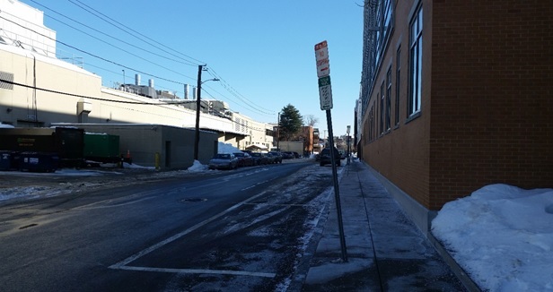 Figure 3- This is a photo of Bent Street taken from its intersection with Fulkerson Street, indicating the wide and open streets that characterize the more industrial areas near the south of the plot. Heavy machinery can also be seen on the roof of the building to the left.
The next block stands out as John Ahern Field contrasts the building heights with an expanse of flat ground, presenting a grass area the same size as one of the three blocks passed thus far (Figure 4). Its uses appear to include sports and recreation, and there is evidence of walking trails under the snow from trail signs. Standing on Fulkerson Street and facing 6th street, to the right stand baize company offices and buildings. As perspective shifts to the left the field comes into view at the ground level, and continuing this path to the left brings into view the brick back wall of the Kennedy Longfellow School, depicting with clarity the gradient-like transition from industrial land to recreational land to land used for public education, all in one glance. These two blocks of the sports field and the elementary school serve as the connection between the industrial and residential sections of the plot, a diversity that can only be reconciled through further historical research. The residential area is starkly different from the first two areas. The buildings are generally tall two story homes for one family, and each has its own parking space if it lies facing 6th street or Fulkerson, otherwise there are fewer available. The other main difference is that each block is divided into three sections, something most easily recognized through the aerial Google Maps view shown before. Directly embedded in these sections is the Sacred Heart Parish Church, which stands somewhat higher than the other buildings in the local area. This residential area is characterized by intimacy, tiny streets suffocated by snow, and a much quieter atmosphere than at the southern end of the plot (Figure 5).
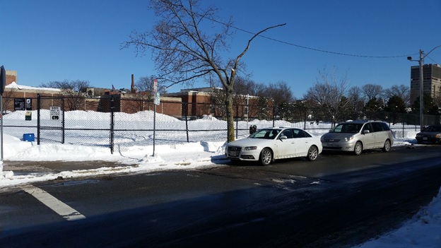 Figure 4- Picture taken at the intersection of Fulkerson and Charles Streets, showing the flat recreational landscape and how it rises again into the Kennedy School marking the beginning of the residential section of the site.
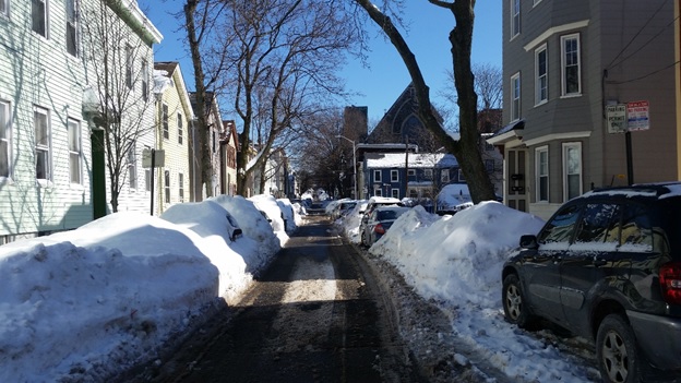 . Figure 5- Picture taken at the intersection of Otis and Fulkerson Street, showing the narrow streets and intimate environment of the residential district. With these houses so close to an industrial sector of the past it is interesting to take into account their proximity and style, and potentially connect their use with an influx of workers that need to live somewhere, though this can be substantiated through research in the future. The Sacred Heart Church can be seen in the background rising above the houses.
I am interested in how one of Grady Clay’s remarks fits into the context of my site. He stated that “special places in cities carry huge layers of symbols that have the capacity to pack up emotions, energy, or history into a small space. I call them epitome districts” (Clay, 38). I don’t see evidence that this describes my plot, but I am interested in how I can challenge this diverse piece of land to see what it has enveloped within its history. I hypothesize that instead of epitomizing Cambridge in a layered way, my site instead embodies Cambridge with layers that exist in a more “horizontal” form. I think that an epitome district is read more vertically with history overwriting certain parts, but that my site lays out the progression of the city and MIT’s impact in a more linear way visible by walking north on Fulkerson street. This interesting visualization is something that I will continue to investigate as I read further into the story of this site.
Works Cited:
Note: All figures in this text that do not fall into one of the citations below belong to the author.
Figure 1: Map from Google Maps, https://www.google.com/maps/@42.3687037,-71.0868648,17z
Grady Clay, Close-Up: How to read the American City (Chicago: The University of Chicago Press, 1980), 11-16, 38-65.