RAISING THE PRESENCE OF MILL CREEK
|
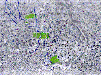
The
urban grid imposed over the topography during times of city expansion will now be
absorbing the natural forgotten outline of the stream. Adapting original Mill Creek with
the actual form of the site leads the project to find crossing points produced by the
contact of the natural system and voids in the urban grid, recognized as public space. Topography as the basic layer of both systems determines the precise location for these crossing points based on the relation of rainwater and its natural path down to the Schuylkill river.The strong relation of Mill Creek and storms which produce flooding at the lower areas will now be managed through the adapted path of the stream and specifically designed public interaction areas. The attraction of these crossing points increased through their development as recreational areas. These serve as a way for the community to interact everyday with Mill Creek and also appreciate its existence.Storm water management begins at the highest parts of the valley and is conducted to the basin where it infiltrates the soil at a slower rate. |