Massachusetts Institute of Technology - Department of Urban Studies and Planning

11.520: A Workshop on Geographic Information Systems
11.188: Urban Planning and Social Science Laboratory

Lecture 10: Model Builder & Review of Labs/Homework

November 9, 2010, Joseph Ferreira, Jr.


Administrative

  • No class tomorrow, Thursday, Nov. 11 (Veteran's Day Holiday)
  • Homework #3: Part 1 (Raster Analysis with ArcGIS Spatial Analyst) due Friday, Nov. 12, 7 pm
  • Test in-lab on Monday, Nov. 15 (2:05 - 5:00) - 2 sample tests from last two years are now online
    • Covers Lab exercises and Lectures through lab exercise # 7 and raster analysis (first raster lecture, Oct. 20)
    • Does not cover ModelBuilder or Internet GIS or advanced raster operations
  • Project Proposals: Short (<1 page on topic, intention, and data sources) proposal due on Stellar by Wednesday, Nov. 17
  • Lab #8 due Wednesday, Nov. 17
  • Homework #3; Part 2 (discussion and model builder) due Monday, Nov. 22

Outline for Today

  • Review labs, homework, and practice tests in preparation for Monday's in-lab test
  • Review recent points from last few lectures ( all *not* covered on Monday's exam)
    • Creating new geometry - create empty shapefile in ArcCatalog, then add geometry via ArcEdit
    • Advanced raster analysis steps - zonal statistics, hillshade, model builder
    • Introduce network analysis methods


Review recent points from last lecture and Homework #3

  • Creating new geometry (lecture 9, Lulu's Slides)
    • create empty shapefile in ArcCatalog
    • then open in ArcMap to start editing
      • Turn on the 'Editor' toolbar, select the layer, choose to 'create new feature'
      • Add geometry and attributes
      • Save and stop editing
    • Registering scanned images and vector data
      • Basic idea: put both layers on screen and 'link' corresponding points
      • Georeferencing toolbar - for raster and CAD datasets
      • Spatial adjustment toolbar - to transform, edgematch or 'rubber sheet' vector layers or scanned images
  • Raster analysis steps
    • Have you set appropriate Spatial-Analyst options: grid cell size, extents, mask, map units, coordinate system
    • You do *not* need to do zonal statistics for HWK #3 part I. Eyeballing which feasible areas are near high concentrations of poor seniors is sufficient for your verbal interpretation of the map and location alternatives. Zonal statistics is what you need to get the average concentration of poor seniors across grid cells in your locations, but we have not yet covered this tool.
    • There are many more raster analysis tools beyond what we are able to cover. Take a look at help pages for: map algebra, zonal statistics, surface analysis and smoothing (contours, hillshade, interpolation,...), and use of model builder
  • Workspace locations (mentioned one more time...)
    • By default, ArcMap on WinAthena PCs will use: C:\Documents and Settings\jf\Local Settings\Temp\
    • This is a network drive - on your H:\ locker - and is an AFS file system (Andrew File System)
    • Hence it is slow and prone to timeouts compared with a local drive
    • For most class exercises, using a network drive is fine
    • But for project work, where you may have larger or more complex shapefiles and data, you may have problems
    • When working with larger layers or complex operations (such as intersections), consider
      • Saving intermediate files locally by:
      • Setting your 'current workspace' and your 'scratch workspace' to a local drive
        • Right-click ArcToolbox/Environment-settings/General Settings
        • Specify local, writeable sub-directories for current and scratch workspaces
        • Before logging out, be sure to use ArcCatalog to copy anything you want to save to a network drive
        • Beware that saved ArcMap documents may not find layers that have been moved - look at properties and 'set data source'
  • Raster Analysis example
    • Review setting up the grid size, extent, and mask options
    • Add a shapefile (that we created last time using ArcEdit) with one or two new polygons over part of Cambridge (which we will call our zones)
    • Use zonal statistics to compute the mean of housing+land value for portion of Cambridge within each polygon in the newly created 'zonal' shapefile
      • Sounds easy but can be tricky because of one of the ArcGIS 'gotchas'. Handling raster layer attribute tables and converting between floating point and integer (think of classification not continuous measurement) is tricky. Raster (grid) layers do not have the same kind of attribute tables as vector layers (such as shapefiles). If the grid cell values are integers , you can open the attribute table (called a 'value attribute table') for the grid layer and it will have one row per unique value together with a count of the number of grid cells containing that value. However, if the grid cell values are floating points (as is the case for the interpolated sales89 grid cell values), you cannot open the attribute table (even though you can generate a thematic map of the values). This is practical since a 1000x1000 grid cell matrix implies 1 million cells whose values, if floating point numbers might all be unique.
      • Using the 'zonal statistics' tool can produce a new raster grid layer with grid cells cookie cut throughout each polygon in the new shapefile and with grid cell values (floating points) that are the same for each grid cell inside each polygon (in the new shapefile) and are equal to the average (or min, max, standard deviation, etc.) of the interpolated house+land value grid cells inside each polygon. It is analogous to the 'summary statistics' command we say earlier but the grouping is based on location (within a new polygon 'zone') instead of based on common values in an attribute table.
      • The new output layer created by 'zonal statistics' does not have an attribute table (since the cell value are floating points) but you can map it thematically (one shade for the average value within each zone)
      • Use the 'zonal statistics as table' tool to create a new table with one row per polygon (in the new zone shapefile) and with columns (mean, min, max, ... values) that are computed based on all the interpolated house+land values for the grid cells in each zone. So the values in the 'Mean' column are the same as the thematically mapped for the 'zonal statistics' result above. You can join this new table to the new polygon shapefile that represented the original zones. Try it.
    • Skim through other spatial analyst tools in ArcToolbox


Network Analysis (not covered on test)

  • Encoding proximity using a network (or graph) model, facilitates certain types of connectivity analyses
    • Find shortest path along streets from Point A to Point B
    • Find shortest path through N cities (Traveling Salesman problem)
    • How far can you get in 30 minutes
  • Many transportation analyses use network data models
  • Many hydological analyses use network data models (runoff, flow, ...)

Network Example: using US Census Bureau, TIGER Line Files

  • Geocoding Strategy using TIGER
    • Encode road network as street centerlines links connecting nodes (usually intersections)
    • Attach address information to each street segment
    • Use 'in reverse' to match street address to street segment to get approximate X,Y location
  • TIGER: Topologically Integrated Geographic Encoding and Referencing system
    • Examine attribute table and note columns for to/from information
    • http://www.census.gov/geo/www/tiger/
    • US Census Bureau TIGER line file 2000, technical documentation
      • at Census: http://www.census.gov/geo/www/tiger/rd_2ktiger/tgrrd2k.pdf
      • in class locker: http://mit.edu/www/data/census2k/tiger_tgrrd2k.pdf
  • Illustrative Example
    Street centerline road segments
    Attaching address ranges to road segments


What is a Network?

A network is a system of linear features connected at nodes
E.g, nodes could be where three or more street segments intersect.
The linear feature connecting any given pair of nodes is called an arc, or network link.
Each arc on a network is represented as an ordered pair of nodes, in the form from node i to node j, denoted by (i, j), and thus has direction.
A network representation that is good for transportation modeling may differ from a geographically accurate representation of the physical road (e.g., street centerline, handling exit ramps, 3D overpasses, etc.)


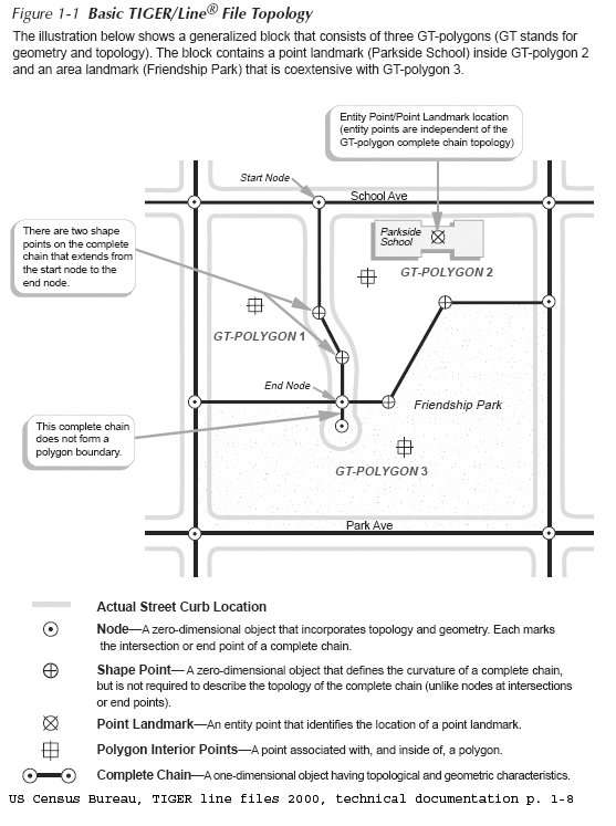
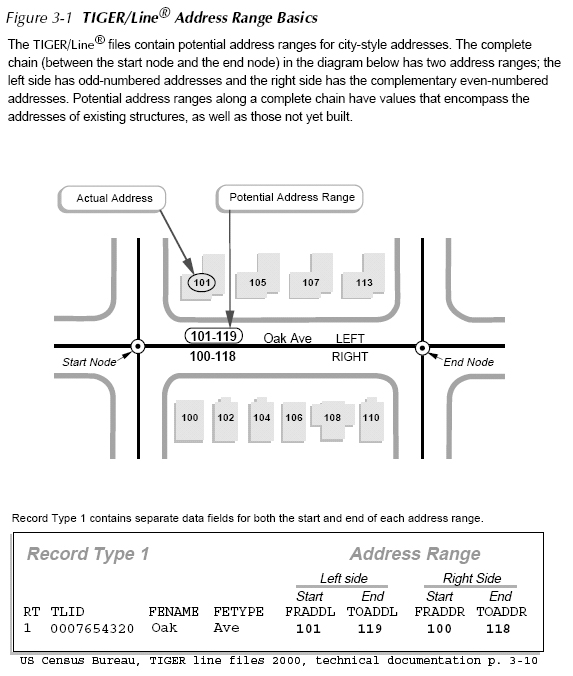
Other basic elements of a network:

A shortest path is the shortest (or least 'cost' path) from a source node (origin) to a destination node.  In practice, pathfinding seeks the shortest or most efficient way to visit a sequence of locations.

A tour is an enclosed path, that is, the first node and the final node on the path are the same node on the network.

A stop is a location visited  in a path or a tour.

Events or locations may be viewed as collection points (e.g., 'origins' or 'destinations' ) where certain resources are supplied or consumed.

A turn on a network is the transition from one arc to another arc at a node (there are 16 ways in which two intersecting roads can allow vehicle flow among the 4 links that 'connect' to the one node).

'Location-allocation' models often use network representation of connected places in order to determine the optimal locations for a given number of facilities (e.g., stores, restaurants, banks, factories, warehouses, libraries, hospitals, post offices, and schools) based on some criteria, assign people to the the 'nearest' facility.


Optional network analysis lab exercise (lab9_network written for old ArcView)


Reference for further information about GIS and networks:

         Source: http://www.ncgia.ucsb.edu/giscc/units/u064/


Last modified 14 November 2007 [jf]. Back to the 11.520 Home Page.
Back to the CRN Home Page.