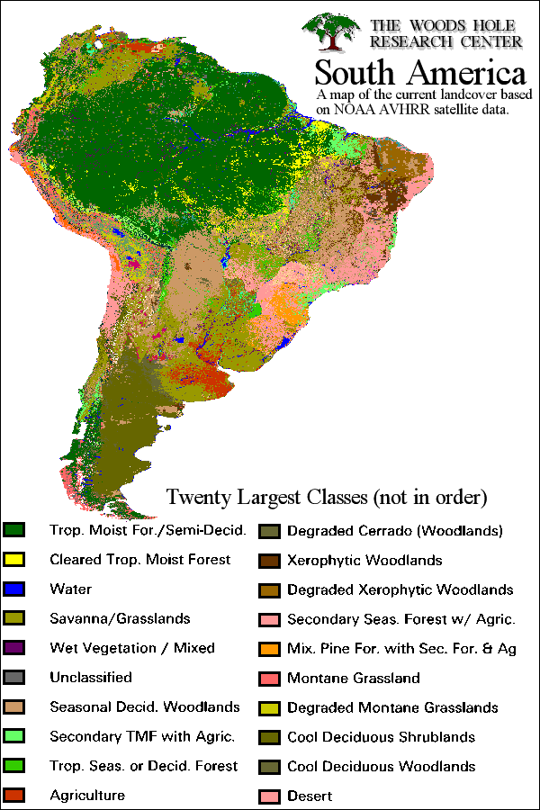
The majority of the Amazon is classified under a single umbrella both in terms of soil and vegetation; however this is primarily because not enough exploration and recording has been done to accurately differentiate the zones. (Click on the map for more information on deforestation).
Historically the Amazon was an inland Sea, but now days it is covered in poor soils “lacking nitrogen, phosphates and potash (http://www.lagamar.com/Pages/ama_geog.html).” Alluvial flood plains on the north and west edges are significantly richer due to annual silt deposits.
According to a German study in the Amazon Floodplain (http://www.atb-potsdam.de/abteilungen/abt1/pdf/amazonas2.pdf), the lack of nitrogen in the soil is largely countered by high levels of nitrogen derived from the atmosphere being held in trees. Luckily these nitrogen sinks are not tied to the seasonal flooding as many had suspected, instead they are largely dependent on species and site conditions (other than flooding).
The world over, there has been established a relationship between the percentage of forest coverage and the population density according to the United Nation’s Food and Agriculture Organization (FAO, see http://www.fao.org/sd/wpdirect/wpan0030.htm). Within the Amazon, this trend is demonstrated with a high resemblance to “wet ecological zones” across the world. Also in the Amazon, the areas with the highest rates of deforestation are also experiencing the highest acceleration of deforestation; the danger areas are only becoming worse.
As a major consequence of deforestation, a combination of surface runoff and soil leeching cause the topsoil to become infertile, and unable to rejuvenate or restore the damaged or destroyed forest (http://library.thinkquest.org/26993/consequences.htm).
According to organizations such as Green Peace, in the last 30 years, an area the size of France has been carved out of the Amazon, and the rate of deforestation is only increasing (http://eces.org/articles/static/98990280082136.shtml). If the land is not suitable for farming or ranching, as research has indeed shown, then this land will need to be abandoned for more freshly cleared Amazon in the near future, only furthering the problem in order to sustain economic growth.
Erosion is the result of some of nature’s most powerful forces, the wind, water and gravity constantly wearing away at any surface they come into contact with. Erosion has been dealt with in a variety of ways in the past, but the appropriate solution for a region is highly dependent on the specifics of climate and the existing land forms. While erosion stands as a negligible threat to standing Rainforest, it is a primary symptom and excellent indicator of recently deforested areas. It is also the greatest enemy in any reforestation, or land fertility stabilization efforts that may be made in the Amazon. It is a matter that needs to be further discussed at length (http://www.fao.org/docrep/T1765E/t1765e00.htm#Contents).
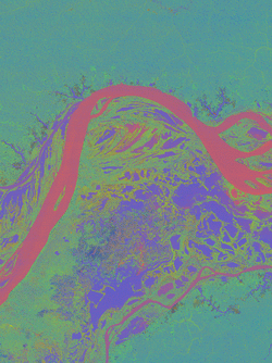
Much can be learned from satellite analysis, such as this image of the Amazon River’s geomorphology (click on the map for additional images).
Things are looking up for our monitoring options, as a late 1998 study (http://www.fao.org/sd/eidirect/eire0008.htm) indicates that a combination of existing data and satellite observations would allow erosion mapping in the Amazon. The pilot program was conducted in Brazil, and suggested that the mapping and data integration could be done for $5.30-$8.06 each square kilometer, with overall economic gains far surpassing these expenses.
The soils of the Amazon are in a manner of speaking, a “wet desert,” (http://www.personal.psu.edu/users/j/m/jmh280/page1.html) meaning that there are virtually no nutrients in the soil itself. There is however, at layer of humus several inches thick on the surface that consists of rapidly decaying organic matter, and supplies the nutrients that plants rapidly absorb. This shallow layer of viable matter causes the roots to be very shallow and outspread, interlocking with neighbors. It is a very quick and easy transformation from this flourishing tropical jungle to a barren desert of clay and barren earth, turning the wet desert into a dry one.
This may be of interest not only to my own team in respect to Land, but also to Water, and Systems Interaction due to the plant available water, and the use of modeling (the availability of raw data is a definite plus). So by using a record of previous profile samplings and digitizing them to a common standard, they were able to model not only the water content of the soil, but also the sand, silt, clay, pH, and carbon levels. To view the maps and raw data, click here.
Research suggests that in some years the Amazon emits more CO2 than it absorbs contrary to popular belief. It is strongly suspected (http://news.bbc.co.uk/1/hi/sci/tech/236276.stm) that the moisture content of the soil, largely a function of porosity and hydrology, is the dominating factor in deciding weather the forest absorbs enough CO2 to out run its emissions.
It has long been known that mercury contamination has plagued the Amazon region’s flora and fauna (including the native inhabitants). For a long time that issue had been blamed on the mercury and other heavy metals used in the gold mining process, but a 1994 joint Canadian-Brazilian study (http://www.idrc.ca/books/reports/1997/19-01e.html) seemed to divert the blame from the mining industry and point towards millennia of natural mercury build up in the soils across the region. Recent deforestation and as a result accelerated erosion, have unleashed years trapped mercury upon an unprepared ecosystem.
This page was last updated on October 27, 2002. If you have any questions or comments, please e-mail the webmaster.