|
|
|
QUICK
LINKS |
|
-- Sea Morphology
Changes and Sensor Placement
|
|
-- Mission 2009
-- MIT |
|
|
Team 5
Proposal for Tsunami Sensor Development
Tsunamis are generated by a variety of occurrences,
including regional uplifting of the sea floor (earthquakes),
underwater landslides, volcanoes, and localized (above water)
landslides. The effects of the tsunamis generated by each of these
ways vary, with underwater earthquakes and underwater landslides
being the most prevalent and most damaging of the tsunami occurrences
(Alaska Sea Grant 2005).
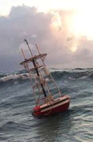
The sensor then transmits the information to a surface
buoy. The surface buoys are protected by steel, lead, and foam,
and cushioned by rubber. The buoy’s main responsibility is to
relay information from the sensors, and it has two identical systems
to do just that in case of a failure of either system[4]. After
receiving the information, the buoy relays it in one of two ways:
either the information is then transmitted to a satellite which
relays the signal to a command center, or the buoy sends a radio
signal directly to the command center. Both forms of
communication have an average delivery time of 3 to 5 minutes, though
radio waves are limited to short-range transmissions due to signal
strength.
The next concern we would like to address is how the
sensors should be deployed into their positions. Buoy
deployment occurs using A-frame structure and crane-equipped boats. The
satellite transmitter should be checked before deployment if possible.
All buoy components should be laid out on deck, assembled if possible
and practical, and secured before boat launch. The total mooring length
is 25% more than the ocean depth. The boat will utilize a buoy first,
anchor last deployment strategy. The boat moves to a point two-thirds
the length of mooring line downstream of the intended dropping site.
The buoy is lifted off the deck using a crane and an A-frame and
lowered into the water. The boat will steam upstream to a distance of
one-third the mooring length upstream from the intended deployment
position with no slack on the mooring rope and release the anchor using
the A-frame and a crane. The bottom packages of a seismometer and the
BPR/tusnameter are designed to be deployed by free-fall through the
water once they are lowered to the water’s surface at a short distance
from the main mooring. The boat should check satellite and
communications to ensure that they are working correctly before leaving
to return to shore.�
Now that we know how we are able to deploy the sensors,
we can compile this information
with other factors, including seafloor morphology and/or risk
assessment algorithms to determine the most beneficial location of
the sensors along the coasts of Micronesia and Peru. The first
factor is the seafloor morphology surrounding the two countries.
The position of the buoys is an important factor. The
areas around Peru and
Micronesia are very different in that the
continental shelves vary in size and degree. The shelf around
Peru can change very rapidly, and as a result of this it might be a
little harder to place a buoy near there. Chile has recently
deployed a buoy near Peru and this one will cover the lower part of
the country. Therefore we would only need to deploy one buoy in
the area and the proposed position is 8 degrees south by 85
degrees west (See: Monitoring Seafloor Morphology Changes).
This is a prime spot because it overlooks the rest of the country and
also watches out for a tsunami coming in from the ocean. It is
at an area where it gives enough time for warning from a potential
tsunami.
In the area of Micronesia we are proposing three buoys.
The buoys will be in locations surrounding the
northwestern to
the south part of the islands. The positions of the buoys in
the vicinity of Micronesia would be about 1 degree north and 161
degrees east, 11 degrees north and 152 degrees east, and 4 degrees
north and 141 degrees east. These locations are prime because
they surround the island in the areas that are most prone to have
earthquakes.
The locations were decided upon data that was collected
from maps and professors. The maps were both topographic
and tectonic. We also used historical evidence from these
to predict where would be the most area prone to tsunamis
based
on the locations and magnitudes of earthquakes.
The second
factor is a much more theoretical approach to
determining sensor location, as it is based upon the development of
risk assessment algorithms that do not currently exist for the areas
in question. In one case we have studied, concerning Japanese
islands, algorithms were developed that were able to determine the
arrival time of tsunamis from a given point (generally a sensor) and
the “ratio of excess,” providing us with information on how
likely it is that a wave will exceed 5 meters when it approaches a
given area of the shore in question. Obviously, this model fits the
Japanese shoreline as opposed to either of the areas we are concerned
with, but the variables influencing the equation- examples being
time, gravity accelerator, water level lift from still water level,
water depth, friction coefficient of the ocean bottom, flux in the x
and y direction, and the vertical amount of seabed displacement- can
be applied to Micronesia and Peru to come up with a similar working
model for sensor deployment [5].
Bibliography
[1]
Smith,
D. (2005). Tsunami: A Research Perspective. Geology Today, 21
(2),
64-68.
[2]
Gusiakov,
V. K. (2005). Tsunami Generation Potential of Different
Tsunamigenic
Regions in the Pacific. Marine Geology, 215 (1-2), 3-9.
[3]
[4]
Meinig, C., S.E. Stalin, A.I. Nakamura, H.B. Milburn (2005). Real-Time
Deep-Ocean Tsunami Measuring, Monitoring, and Reporting
System: The NOAA DART II Description and Disclosure.
www.pmel.noaa.gov/tsunami-hazard/ [5] Sato, Hiroaki., Murakami,
Hitoshi., Kozuki, Yasunori., Yamamoto, Naoaki. (2003).
Study On
Simplified Method of Tsunami Risk Assessment. Natural
Hazards, 29,
325-340.
![]()