


Environmental Determinants of Malaria Transmission
project overview | model development | project collaborators
Model development- hydrology model
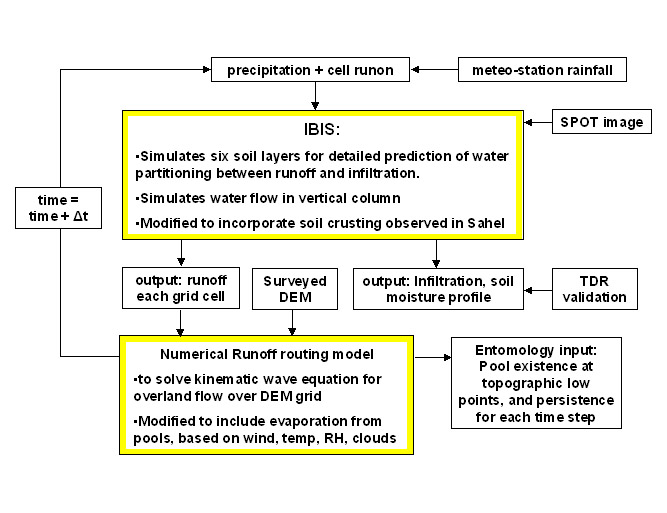
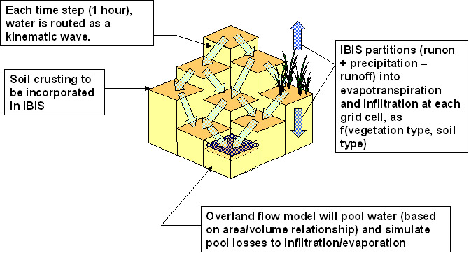
IBIS (Integrated Biosphere Simulator) will be used to simulate the soil moisture profile and runoff generated by each grid cell. IBIS simulates six soil layers and two vegetation layers for a comprehensive, detailed simulation of the role vegetation plays in the land/surface hydrologic processes in the vertical column. The model is forced by climate data, and provides a method for quantifying soil moisture dependence on vegetation type and soil type conditions. IBIS simulates at an hourly time step in the soil surface module, and therefore presents a useful tool to understand soil moisture and runoff responses to small-time-scale precipitation events with spatially variable land cover conditions as exist in the Sahel. IBIS simulates soil moisture in the vertical column using a Richards equation solver, but does not address cell-to-cell interactions within the model grid. IBIS only predicts the water available for surface runoff for each grid cell, but run-on and run off from each grid cell cannot be simulated using a stand-alone version of IBIS, nor can intercell groundwater flows be incorporated. To overcome this deficiency in IBIS, the model will simulate hortonian runoff processes in response to a distributed rainfall field throughout each micro-catchment. The mechanism for this will involve a finite difference solution of two-dimensional hydrodynamic overland flow equations. Model input will include two remotely-sensed data sets: vegetation and soil types from a 10-meter SPOT visible image, derived using a supervised classification technique, and small-scale topography measured by the ERS-2 satellite synthetic aperture radar combined with field-surveyed points. IBIS- predicted runoff for each grid cell will be routed each time step, and the resulting run-on onto the down-gradient grid cell will be added to the available precipitation for the next iteration in IBIS. Overland flow routing is performed using the kinematic wave approximation to the full hydrodynamic equations, incorporating backwater effects to allow pooling, and the model formulation includes the dynamic effects of interactive infiltration caused by spatially variable soil and vegetation properties. The following schematic depicts the topography-dependent overland flow for each time step.
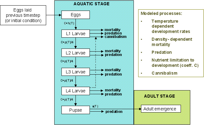
Hydrology model outputs will provide input for the individual-based mosquito model. Pool formation and persistence will be predicted for each time step by the hydrology model and written as output files, over the entire model domain. These output files will provide the necessary conditions for simulated mosquitoes to breed and propagate in the next component of the coupled model. Certain of the simulated pools (those simulated to form in microtopographic depressions) with favorable characteristics will provide suitable breeding habitat for the anophelines and in the computer simulation will act as sources of adult mosquitoes as long as they persist longer than the required development time of the subadult stages (eggs, four larval instar stages, and pupa). The model simulates the advancement of sub-adult stages according to the following diagram. Stage advancement rates are temperature-dependent, and are limited by each pool's ecological carrying capacity.
Model development- entomology model
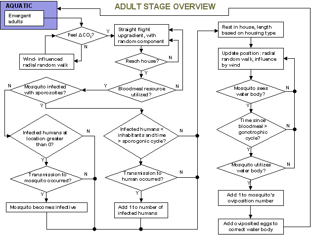
Once the simulated sub-adults have advanced to the adult emergence stage, they enter a two-dimensional model domain in which individuals are tracked and interactions with the environment and villagers are simulated as follows: