


Environmental Determinants of Malaria Transmission
project overview | model development | project collaborators
A novel approach to understanding an ancient scourge
Overview
Malaria is inextricably tied to water. Because malaria vector mosquitoes utilize naturally occurring water bodies for breeding, malaria can not exist in regions where environmental conditions prohibit the formation and persistence of natural water bodies. Consequently, for regions where water availability limits mosquito populations, hydrology models can provide useful predictive tools for vector mosquito population dynamics, and therefore malaria force of infection. We are addressing the inherently cross-disciplinary nature of this problem using numerical modeling techniques at the appropriate spatial and temporal scale, and expect that this will result in an improved understanding of malaria dynamics in water-limiting regions. The West African Sahel is one of the most malarious regions in the world, and is also subject to pronounced interannual climate variability resulting from sea surface temperature fluctuations in the Atlantic Ocean. Recognizing that malaria transmission levels are closely related to climate conditions, we seek to evaluate the effects of climate variability on malaria incidence.
Due to the lower levels of natural immunity resulting from lack of year-round sustained malaria transmission, zones of unstable transmission such as semi-arid regions or transition zones between malaria-endemic and malaria-free regions are often subject to periodic severe epidemics when environmental conditions shift to favor transmission. The African Sahel region is no exception. Because of this unstable malaria transmission and sensitivity to shifting environmental conditions, we focus our effort on a representative section of the Sahel, two villages in southwestern Niger, Banizoumbou and Zindarou.
Objectives
Project objectives can be summarized as follows:
• develop a calibrated, field-validated, coupled hydrology/entomology model which operates at fine spatial and time scales
• at this high spatiotemporal resolution, explore environmental determinants of adult mosquito abundance
• evaluate sensitivity of predicted malaria transmission to individual climate variables
• evaluate potential village-scale intervention scenarios
Background
Estimated annual mortality from malaria is in the millions. The disease burden is particularly severe in sub-Saharan Africa, with the region accounting for 60% of the world's clinical malaria cases and 80% of worldwide malaria deaths (WHO, 2005). This disproportionately high malaria burden is due primarily to the dominance of Plasmodium falciparum, the most severe and fatal form of human malaria, as well as behavioral traits of the principal vectors of the disease , Anopheles mosquitoes.
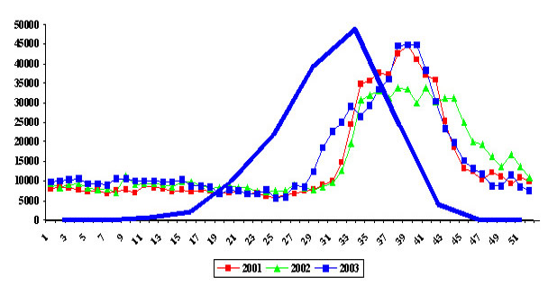
Weekly malaria prevalence in Niger for the period 2001-2003, with the average monthly precipitation data for the HAPEX-Sahel square degree from GPCP.
The figure at left shows three years of malaria incidence data in Niger, superimposed by GPCP average monthly precipitation data for the period 1979-2004. Seasonality of both rainfall and malaria incidence are expected to be related because of the ecology Anopheles arabiensis, the dominant vector in this region. It exploits predominately shallow, rainwater pools following intense wet season storms to form the link between the wet season and the malaria season. Clearly, this link is very strong.
In addition to precipitation-driven pool formation, environmental variables can affect the transmission of malaria in a number of ways. First, the temperature of water bodies (influenced by solar radiation, rainfall, and air temperature) governs the development rate of aquatic stages from eggs to adult emergence. After adult emergence, wind speed and direction influence the host-seeking behavior by directing carbon dioxide and human odor plumes downwind. Detection of CO2 and odors with human signature above background levels triggers host-seeking behavior and induces flight in the direction of the odor source. Ambient temperature as sensed by the adult mosquito strongly affects gonotrophic and sporogonic development rates, and relative humidity and temperature are thought to influence survivability. All of these effects combine to form a complex system of malaria's dependence on environmental conditions, best studied using mathematical modeling techniques explicitly simulating each contributing process. The following schematic shows the environmental influences affecting mosquito population dynamics and malaria transmission in the mosquito life cycle of alternating host seeking/ oviposition seeking behavior.
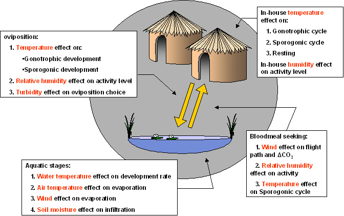
As a an adult mosquito alternates between host-seeking and oviposition (egg-laying) behavior, there are a number of ways evironmental variables can affect malaria transmission and population dynamics. These are presented here. Sporogonic cycle refers to the development of sporozoites in the mosquito, and is a temperature-dependent process. Gonotrophic (egg-development) rates are also temperature-dependent.
Our approach
Our approach focuses on fine-scale simulation of the mosquito population. This is done using an individual-based entomology model coupled to a dynamic hydrology model. The hydrology model predicts the locations of rainwater pools after rainstorms, and their persistence. Mosquito population dynamics are therefore modeled at an appropriate scale to capture the interaction of individual mosquitoes with the physical environment.
Hydrologic conditions (soil and vegetation types, extent of precipitation events) can vary substantially within a grid cell of climate models. We expect that this work will allow this variability to resolve mosquito population response (and therefore malaria force of infection) at the village scale thus complementing ongoing efforts to develop malaria early warning systems, and perhaps filling in gaps due to climate model resolution limitations.
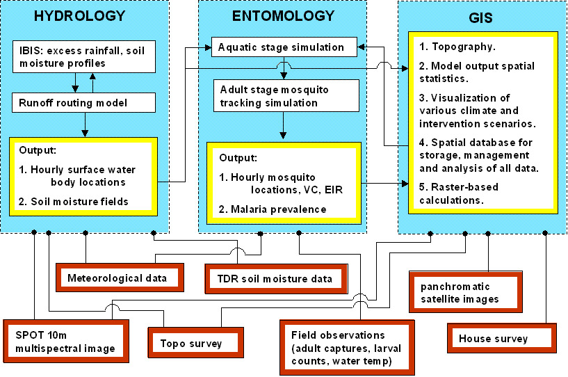
The conceptual layout of the coupled models. An existing hydrology model, the Integrated Biosphere Simulator (IBIS) of the University of Wisconsin, simulates water in the vertical column in six soil layers and two vegetation layers. This model, which simulates rain water partitioning into evaporation, infiltration, and runoff, will be modified to allow intercell runoff computation. The resulting pool locations as predicted by the model act as the input for the entomology model, and allow subadult mosquitoes to develop into adults. Emerging adults are tracked in a 2D model domain individually as they interact with the environment. The GIS is an integral component of the coupled system and serves to perform spatial statistics calculations, visualizations of inputs and outputs, and so on. Input data for the various model comonents is included in the bottom of the figure.
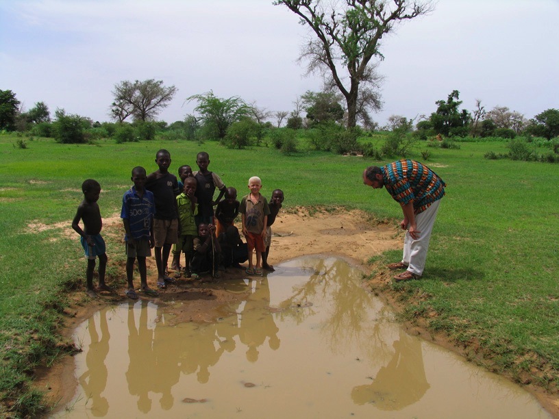
Field study location - Banizoumbou and Zindarou, Niger
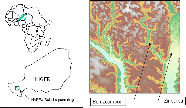
Location of the field study site. The two villages are located within the intensively-studied HAPEX-Sahel square degree (2-3 E, 13-14 N). The figure on the right depicts SRTM topography data for the HAPEX-Sahel square degree, with the Niger River on the left and the abandoned river channel of the Dallol Bosso on the right.
For this study, we have identified two villages in the HAPEX-Sahel square degree (2-3 E, 13-14 N), Banizoumbou and Zindarou, as subjects for intensive hydrologic and entomologic observation. The reason for selection of these two villages is two-fold. First, they represent typical human population conditions for many of the Sahelian villages, yet they are different in that they are situated in two hydrologically distinct regions. Banizoumbou is located in a semi-arid plateau landscape of tiger bush, millet fields, fallow and bare soil. The endorheic nature of the surrounding watersheds and the large depth to the groundwater table result in relatively low levels of surface water ponding. This is in contrast to Zindarou, which is situated in the more lush and fertile abandoned river basin of the Dallol Bosso. Here, the groundwater table is only about one meter below the surface, supporting abundant vegetation.
The area is characterized by larger, vegetated pools, and substantial surface water/groundwater interactions, as emergence of the phreatic groundwater table is observed in the form of large flooded areas during the peak of the rainy season from late July through early September. In addition, many shallow unimproved wells dot the area which villagers use to water vegetable gardens. These wells are variable in nature but often contain emergent vegetation and clean, clear water. As such, they present ideal breeding habitat for An. funestus, a slightly more zoophilic yet very dangerous malaria vector which generally prefers to breed in permanent pools of clear water with vegetated fringes.
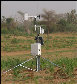
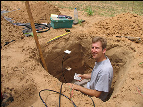
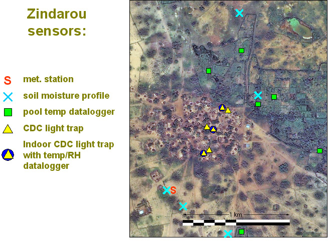
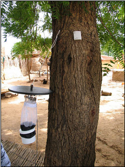
A number of sensors and dataloggers have been deployed in the two villages. The following are two images from the Quickbird and Ikonos satellites, with sampling locations.