John Muir Trail Trip, Summer 2005

Day 8: Rock Creek to Lone Pine, CA

Day 7: Wallace Creek to Rock Creek
Days 9-14: Lone Pine, CA to Boston, MA

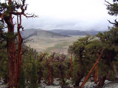
Siberian Pass from the alternate route
The day dawned very grey, and the rain we'd heard at 2200 last night didn't let up. The tent, which was water-resistant rather than waterproof (last time we make that mistake!) turned into a bathtub, soaking my down sleeping bag and most of my other gear. Based on our situation (wet down does not dry out in the backcountry, and it was cold and we were at high altitude - around 10,000 feet) we opted to hike out the remaining 12 or so miles to the trailhead rather than camping out one more night as we'd originally planned. Even if the rain had let up, our gear was just too wet to dry in time for nightfall, and wet sleeping can lead to hypothermia among various other things.

We were cold and wet when we left camp at 0930 - but by about 1100 the rain had let up and we were optimistic about getting out but worried about the thunderstorm conditions, as we had a major pass to cross before Cottonwood Pass and lightning was a big concern.

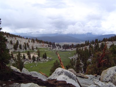
Small alpine meadow just past the alternate route's high point
At about 1200 it began to rain again (surprise surprise) and it got windy and rapidly colder. We'd been hiking across a large wooded plateau just north of Siberian Pass; the Pass itself was still ahead of us, although we apparently were set to take a route higher up on Cirque Peak's shoulders due to environmental damage at Siberian. Now my concern was hypothermia instead of lightning - I was pretty close to getting the shakes, although this was prevented by putting my poles up with my gear and donning appropriate warm outerwear and keeping my gloved hands in my pockets. Eating an energy bar also helped me regain enough blood sugar and energy to think positively, which made a huge difference. I had already been wearing long underwear, a long sleeved-shirt, pants, and a raincoat, so this was a good step forward.

Thankfully the alternate (higher) route ended up being mostly tree-covered, though we were only 20 feet or so short of treeline at some points. The rain again stopped at about 1300 when we topped the pass (11,320 feet) - our last steps inside Sequoia National Park. We met a solo woman hiker from Maine who reassured us that making it down would be fairly easy, which helped my confidence tremendously.

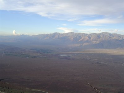
Owens Valley on the way down from the trailhead
We followed a contour for a while (a very long while compared to the rest of the trip), then descended to Chicken Spring Lake, our planned final sleeping place. The lake was beautiful and clear blue, and it's a pity we couldn't stop to spend the night. We then went over Cottonwood Pass (11,050 ft). There were 35 switchbacks down Cottonwood (I passed the time by describing the correspondances between the first 24 and MIT's first 24 course numbers to my father), but at the bottom there were giant mushrooms and the green spread of Horseshoe Meadows.

We hiked hard - at least 2 miles an hour - and reached the Cottonwood Pass trailhead at around 1800 with enough light to see and take pictures by. We'd covered 12 miles that day (more than any day previously) in 8 hours. After driving down the steep and somewhat frightening road from trailhead to valley floor, we crashed in a motel in Lone Pine after a hot shower (heavens! so nice) and food. I had a buffalo bacon cheeseburger and a glass of Coca-Cola - quite a change from freeze-dried lasagna.

Day 7: Wallace Creek to Rock Creek
Days 9-14: Lone Pine, CA to Boston, MA


Back to top.