| RiverRat - An MIT iCampus project | http://web.mit.edu/riverrat/ |
After writing different organizational documents, we were finally able to start the "hands-on" work. We spent a month researching what is the technology currently available, and we found the there are plenty of choices for each individual components that will go into our system. We finally narrowed it down to one or two product for components, and ordered development kits to start testing them.
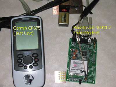
During Spring Break, we started to receive part of the hardware components that we had ordered. Although most of the team members were not around, Scott abd Rob decided to try to get the MaxStream set of radios to work. They connected a off-the-shelf handheld GPS receiver, a Garmin 76, to one of the adapter boards of the development kit, then the second radio to a laptop computer.
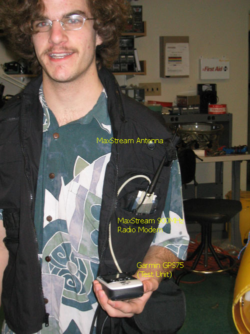
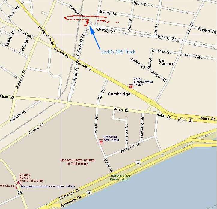
After playing for a while with the radio settings, they were able to make the GPS talk to the laptop, and a strem of NMEA data start to come in. Scott then stuffed a vest with the GPS, radio and battery and went for a walk around Kendall Sq. in Cambridge, MA, while Rob using a program he had written track and displayed Scott position on a map. The position on the map is not accurate, as the system was not calibrated.
The core of the system is working!
Once we knew that the radios were working properly, the next task was to prove that we could track a boat all around the part of the Charles River in front of the Sailing Pavilion, the one between the Longfellow Bridge and the Harvard Bridge. The task started with Claudio and Scott installing a high gain antenna on the flagpole on the roof of the Sailing Pavilion. This antenna increases the range of the radio reception, by boosting the incoming signal.
With the antenna in place and the cable brought to the upstairs office at the pavilion so that it could connect to the receiving radio and the laptop, we made sure that the system was working properly, before taking a boat ride on the river. It took few adjustments and the right cables, but the data was now coming in. Doug and Claudio jumped on one or the motorboats and drove around the shoreline, while Scott at the pavilion was making sure that the data was logged and displayed correctly.
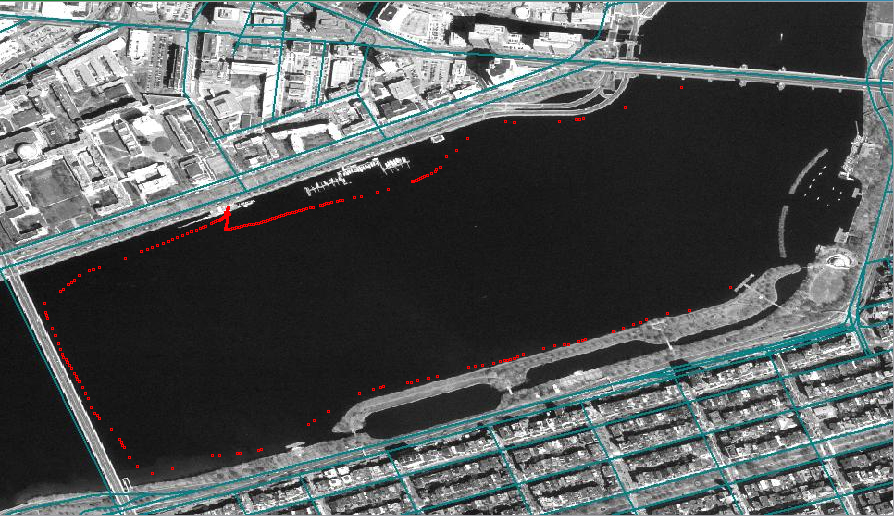
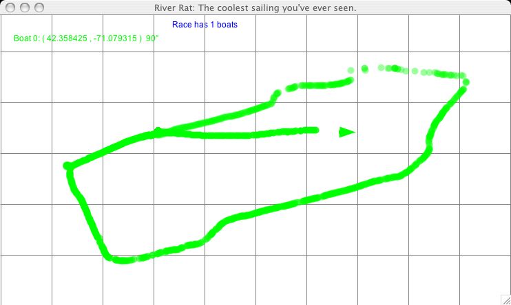
After 30 minutes out in the cold, we could say that this second test worked, as the picture above shows, although probably not as well as we hoped. The track shows that the signal was lost in different places around the shoreline. Near the Longfellow bridge (right part of the map), we believe this was due to loss of the radio signal. The trasmitting radio and antenna were sitting on the floor of the motorboat, position we realized later not ideal for best transmission. Other holes in the track might be due to loss of satellite signal on part of the handheld GPS. Few times the display showed a loss of signal from most of satellites for a few seconds, after which it was regained. How this played into the final result needs more evaluation, that for time constraints was not done on this day.
The day started with four task on our minds:
Doug and Scott installed the AeroComm tutorial software on the laptop and tried to get data from the Garmin 76 GPS using the AeroComm radios. After spending a good amount of time dealing with all the settings, they managed to transmit and receive a stream of data, however, it immediately became clear that the data had been badly corrupted during the transmission. A call to AeroComm customer support only got them a voicemail.
In the meanwhile Claudio scavenged and old plastic box, which he decided could be turned into the enclosure for the sensor package. Because the intention was to test both radio sets capabilities, the box had to contain two radios, the GPS engine, the batteries, and all the necessary cables. It turned out to be a snug fit, but after a couple of hours of assembly, the sensor was ready to be taken out on the water, with the three antennas (two radios plus the GPS one) mounted on the cover.
After giving up on the AeroComm radios, Doug and Scott went to work to make sure that the logging and displaying software was ready for the on-water test.
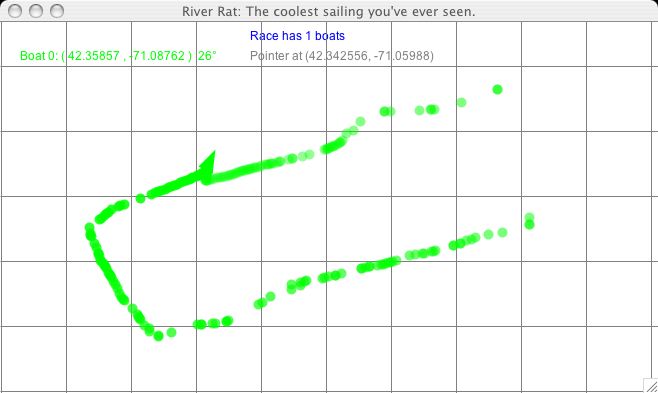
The test was basically a repeat of what we had done the previous week. With the sensor package sitting on the console of one of the sailing pavilion motorbaot, we drove around the river along the shore line, to see what the reception looked like now that the antenna was standing up instead of laying on the floor of the boat. We expected, and hoped, that we coverage would improve, and when we looked at the track (in the picture below) we had the pleasant surprise that the radio link was lost only in one location on the river: at the corner of Memorial Drive and the Longfellow bridge, a location where boats will rarely go during recreational sailing, and never during races.
For sake of comparison we plotted the previous test track using the same software. The improvement in coverage is very encouraging.
Click Here for
this summary