“The urban landscape is a repository of environmental memory far richer than any verbal codes.”
–Dolores Hayden (Hayden 227)
Like the various other Chinatowns and ethnic enclaves scattered across the United States, Boston’s Chinatown is a neighborhood rich with culture and history. As Dolores Hayden articulates in her book The Power of Place, “human patterns impress upon the contours of the natural environment” (Hayden 14). Indeed, previous inhabitants have left their marks throughout my site from South Station, to a strip of the Leather District facing Chinatown, to Chinatown itself, in the form of various artifacts and traces. These form “layers” in the physical landscape that tell the stories of different peoples and the conditions of the time periods they belonged to. The architecture of certain buildings within the Leather District evokes the industrial boom of the 1850s, whilst other neighboring structures possess more modern, upscale features, hinting at new trends changing the face of the area today. In Chinatown, one can witness hints of the presence of the first Anglo-Saxon, middle class families that built their homes there in the early 19th century, the remnants of the struggles Chinese immigrants faced as they tried to settle in despite discrimination and marginalization from city authorities, as well as signs of the Chinese community’s assertion of their rights in more recent years. These are but a few of the diverse range of layers that characterize the landscape of Chinatown. This essay will seek to understand each distinct layer of my site chronologically, so as to gain an understanding of its historical narrative, as well as glean a sense of what its future holds based on current trends shaping the area.
The Residences and Industries of the 19th Century:
After Boston’s authorities first filled in the marshes and mud flats to create this area in the early 1800s, the first settlers were Anglo-Saxon families. This is shown by the historical maps depicting compact, uniform residences, branded with the Puritan last names of their owners, referenced in Assignment 3 (“Site through time”). By comparing different maps of the area over time, one can see that many of these residential blocks were eliminated in later years to pave the way for new developments. However, a few structures were left untouched in two parts of the site: the heart of Chinatown, bounded by Beach Street, Kneeland Street, Tyler Street and Surface Road, and the southern region of Chinatown stretching from Kneeland to Oak Street. Figure 1a shows a wide-angle view of a row of these preserved residences in central Chinatown, behind a parking lot.
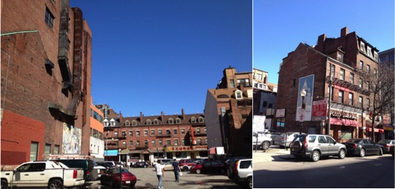 Figure 1a on the left and 1b on the right
These four story structures seem to have remained largely unchanged since the early 1800s, although most of their first floors have been converted into restaurants or small business storefronts. They all have the same diagonal, sloping, tiled roofs, the same vertically rectangular windows characteristic of New England, the same chimneys and rooftop windows jutting outwards and of course, the same red brick façade. Figure 1b shows a close up of one of these buildings. Figure 2 shows an almost identical set of these brick, residential buildings, except they are located in between Hudson Street and Surface Road, in the southern, residential district of Chinatown.
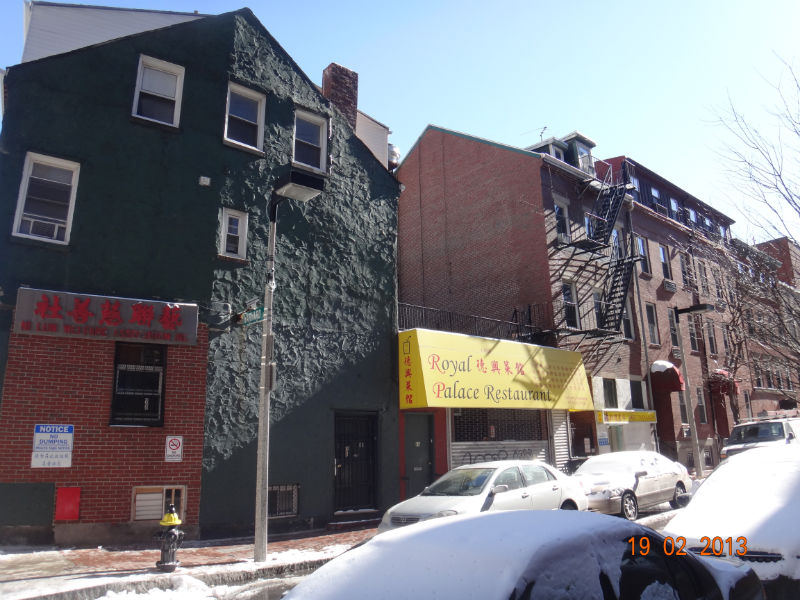 Figure 2: 19th century residential homes in southern Chinatown
Based on the smattering of these virtually identical buildings throughout Chinatown, one can imagine that back in the 1800s, this neighborhood might have been totally made up of rows of these identical residences, as the earliest historical maps seem to indicate. Since each house is built right up against the next (there is no spacing in between each structure), one might assume that the same developer built all of these structures at once. Or alternatively, perhaps every family constructed their home in the same style due to similar middle class economic backgrounds. Other traces that reaffirm this interpretation can also be found scattered all across Chinatown, in the form of outlines of demolished four-story brick residences imprinted against various newer buildings, as shown in Figure 3 below.
 Figure 3: Outlines of demolished 19th century residences against newer building
Though its specific inhabitants may have changed over time, as various different ethnic groups came and left the area, Chinatown has remained a relatively low-income area, with its property values suppressed by neighboring industries and railroads. Thus, perhaps new developers that came to build warehouses and taller apartment buildings in the neighborhood sought to cut costs by capitalizing on existing structures and incorporating already standing walls into their new structures, inadvertently leaving a clear historical, architectural remnant. The undesirability of the neighborhood might have also contributed to the preservation of some of these four story brick residences. Today, some of these buildings, especially in the southern part of Chinatown, continue to be private residences, whereas others in central Chinatown have ground floors that have been converted into various stores and Chinese restaurants.
A 19th century layer can also be identified in the neighboring Leather District. However, this layer evokes a different aspect of that time period: the onset of industrialization in the 1850s onwards. In the inner regions of the Leather District that do not face any major roadway, such as along Utica Street, one can find 6 story red brick buildings, encased in an armor of wrought iron fire escape stairs, as shown in Figure 4 below. These buildings may date back to the late 1800s, as an 1895 Sanborn Fire Insurance Map shows that “Leather” warehouses and factories had already begun cropping up along Utica and Lincoln Streets back then. Most of these fire escapes were probably installed just before the turn of the 20th century—when fire escapes became more commonplace across America—perhaps not long after Boston’s Great Fire of 1872. The tall, box-like structure of these buildings suggests they were initially designed to house industrial operations. As such, walking along the inner alleyways of the Leather District, one may still feel as if he or she was walking through the pathways between factories in a dense, industrial area, even though most of these old buildings in the Leather District have been converted into restaurants, clothing stores, office buildings, or modern loft-style apartment buildings . Figure 4 also shows an interesting artifact: the photo on the right depicts a brick sky corridor connecting two similar, industrial-looking brick buildings. Perhaps, in a past era, this corridor was constructed to facilitate easier transportation of people and goods between two leather warehouses owned by the same company.
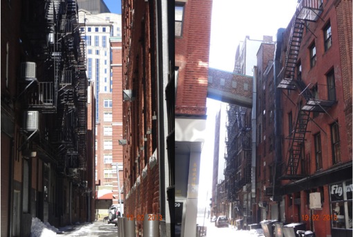 Figure 4: The 19th century industrial buidings of the Leather District
Discrimination and The Depression
The 20th century marked a new era for Chinatown: as external forces like advancements in transportation technology –such as Henry Ford’s development of his famous Model T – propelled increasingly large waves of middle class families to move to the suburbs, immigrants gained the opportunity to truly settle in to the “Chinatown” area. However, this time period also saw racial tensions and discriminatory sentiments against the growing Chinese population escalate, manifesting in a series of harsh brushes with the law. In his online paper “Landscape and Memory: an Archaeology of Boston’s Chinatown”, graduate student Alexander Keim describes a murder due to violence between tongs, or gangs, in the area, that brought “up to 20,000 Chinese mourners, a majority of them from outside Chinatown” to the area (Keim 10). Boston’s police force actually took this opportunity to identify and deport illegal immigrants, detaining 250 people and eventually deporting 5 (Keim 10). As Keim opines in his paper, “this obvious incidence of harassment illustrates the degree to which the Chinese in Boston were thought to be inherently criminal, dishonest, and undeserving of basic rights” (Keim 10). Though not many physical traces of this violence and discrimination are apparent in the landscape, what can be seen is the response of the Chinese population to this marginalization in their efforts to survive. According to Keim, “Chinese cusine started to become popular among White Americans in the 1920s” and “Chinese restaurateurs began to erect neon signs and anglicize the names of their establishments in an attempt to attract the non-Chinese market”. Perhaps this accounts for the layer of flamboyant, exaggeratedly – almost comically – Chinese architectural features and restaurant signs embellishing select, old buildings in the central part of Chinatown, as shown in Figure 5 below.
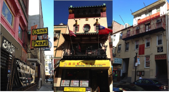 Figure 5: Gaudy, exaggerated Chinese decor
Restaurateurs in the 1930s or 40s might have added certain architectural features, such as the pagoda style roof element shown in the middle picture and the red outer façade of the building in the leftmost picture, in an attempt to oblige to the stereotypes Western diners had of what a Chinese establishment should look like. The desire of Chinese immigrants to gain the acceptance of the established Bostonian community could have given rise to the unique, Chinese-American, Chinatown stereotypes we have become familiar with today, from the chopstick-style font used on takeout boxes and restaurant signs, to the invention of fortune cookies, to the brightly colored architectural elements mimicking ancient Chinese palaces. These are characteristics unique to Chinese enclaves in America, virtually absent in Mainland China itself, an example of the phenomenon described by Dolores Hayden in her book: “places also suffer from clumsy attempts to market them for commercial purposes: when small towns in Iowa that once seemed to embody everyday life in the Midwest developed ‘themes’ to make them more attractive to tourists, the places became caricatures of themselves” (Hayden 18).
This time period also ushered in the Great Depression and all the woes that came with it. According to Keim, “dramatic drops in property value led some owners to demolish their buildings rather than pay taxes…In Chinatown, approximately one third of housing was demolished” (Keim 13). These changes are apparent when one compares a Sanborn map of Chinatown from 1938 to one of it in 1951: entire swathes of residences are replaced by huge parking lots, or simply vacant lots. Traces of this destruction are still evident throughout the site today in the form of the parking lots interrupting rows of buildings with the imprints of destroyed 19th century residential buildings on their sides as shown in Figure 1a above.
However, after World War II, anti-Chinese sentiments began to quell, thanks to the US-China partnership during the war as well as the subsidence of violence within Chinatown. This allowed the Chinese community to truly begin to settle in to their new home – this would become the permanent home of many since they soon became unable to return to China after the Civil War and the ascent to power of the Communist party. An artifact from this time period is the Chinese Merchants Association building (which also served as a community recreation center), facing Surface Road at the intersection of Kneeland and Hudson Streets. According to Keim, this was the first building the Chinese immigrants managed to fund wholly on their own, symbolizing their newfound sense of economic independence and cultural legitimacy (Keim 19). However, after the elevated railway was dismantled in 1941 and factories began to leave the Leather District and move out to the suburbs of Boston, Boston’s more prominent institutions and authorities began to encroach upon this once undervalued area, with dramatic implications for the landscape that had been developed by the Chinese community (Keim 18).
The Threat of Urban Renewal
On page 22 of her book, Hayden explains “one of the consistent ways to limit the economic and political rights of groups has been to constrain social reproduction by limiting access to space” (Hayden 22). In the case of Chinatown, the initial expansion of the Chinese community over undervalued land was uninhibited. However, as World War II veterans returned home and the country experienced the post war economic boom of the 60s and 70s, the city of Boston did try to reclaim this formerly unwanted land for public projects, such as the expansion of Tufts University Medical Center and the construction of the I-93 highway, the Massachusetts Turnpike, and Surface Road. These recent, large-scale developments form another layer throughout Chinatown that reflects the rising value of this centrally located area. The former Chinese Merchants Association Building, or what remains of it, is an artifact from this time period: half of the building was removed to make room for the construction of the highway. Figure 6 depicts the building as it stood in 1951, while Figure 7 is a photo of the building today.
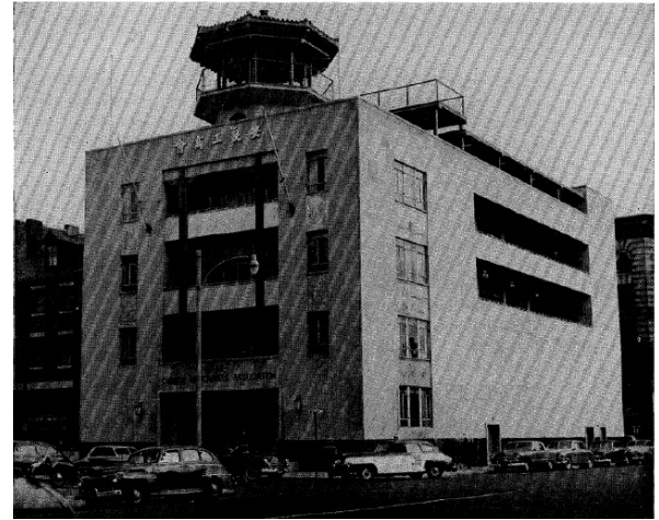 Figure 6: Photo of Chinese Merchants Association Building in 1951 taken from "Landscape and Memory: An Archaeology of Boston's Chinatown" (Keim, Alexander) from http://www.academia.edu/1286793/Landscape_and_Memory_an_Archaeology_of_Bostons_Chinatown
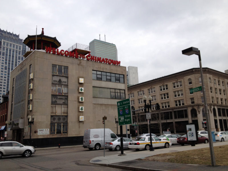 Figure 7: What remains of the Merchants Association Building today
By comparing the two, one can see that an entire portion of the building has been removed, thus accounting for the awkwardly flat face and strange window distribution that characterizes the highway facing side of the building today. The gaudy, red “Welcome to Chinatown” letters facing incoming cars from the highway exacerbates the strange appearance of this building, further highlighting the ways in which Chinese immigrants have tried to adapt to new, Western surroundings. This building is the only visible trace left of the swathes of residences eliminated during the 70s. These included the entire strip of residences along Albany road, now replaced by an expanded Surface road leading to the I-93 highway. Keim cites the Boston Redevelopment Authority when noting in his paper that “the 1960s saw half of the total surface area of Chinatown destroyed, including 1200 housing units” (Keim 19). The dramatically changed landscape of the southern part of Chinatown that exists today, with large parts occupied by Tufts Medical Center, parking lots, and government subsidized low-income apartment complexes such as Tai Tung Village, reflect the influence of the national trend of urban renewal as it swept through this region of Boston. Thus, as various different larger trends, such as industrialization, suburban flight, anti-Chinese discrimination, and urban renewal, shaped the United States, this site was also imprinted with a series of traces turning it into the diverse patchwork of layers it is today.
Modern Day Revival
The past few decades have witnessed a resurgence in the strength of the Chinese community’s presence in the area. Walking through the Leather District today, one can see that the buildings facing Chinatown are mainly occupied by Chinese office businesses, such as various Chinese newspapers, a kitchenware store, and a Tai Chi association, amongst others, as shown in Figure 8.
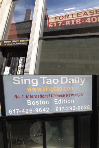 Figure 8: Chinese businesses in the Leather District
The persistence of the Chinese residents has not allowed the construction of the highway to curb the expansion of their businesses. Reinforcing the notion of a Chinese revival are what appear to be murals celebrating Chinese culture scattered throughout the site, such as those depicted in Figure 9 below.
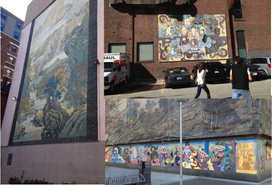 Figure 9: Murals celebrating Chinese culture in Chinatown
These murals depict everything from natural landscapes painted in the traditional Chinese style, to spiritual figures from Buddhism and other faiths, and to characters from the popular Chinese saga Xi You Ji, or Monkey King. Perhaps these were the result of a concerted effort on the part of the government to create a more comfortable, welcoming environment for the area’s Chinese residents. With the restaurants and businesses in central Chinatown thriving as a popular leisure destination amongst locals and tourists alike, and southern Chinatown housing numerous immigrants in government constructed towers or 19th century buildings, it seems like Boston’s Chinatown is in good shape to continue to thrive well into this next century.
The Leather District, on the other hand, seems to be undergoing some dramatic changes in land use: more modern, upscale office buildings and loft-style apartment buildings are being constructed in the area. Perhaps the industrial appeal of the red brick buildings and wrought iron fire escapes attracted young, hip artists, entrepreneurs and professionals. Later on, large real estate developers might have followed suit when they began to realize the convenience of the area’s prime location. As a result, this area is now seeing numerous “Office Space/Apartment for Lease” signs, as well as new businesses such as an art gallery and clothing store founded by a group of MIT entrepreneurs, crop up, as depicted in Figure 10 below. Perhaps, the Leather District will become a destination in itself in the future, as developers continue to invest in the area.
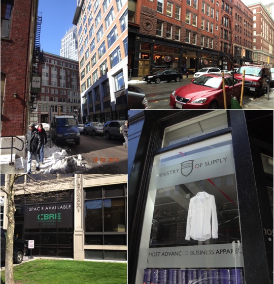 Figure 10: Newer upscale commercia, office, and residential developments in the Leather District
When walking through this site for the first time, one’s attention may be grabbed by the pungent smells wafting out of restaurants, or the variety of wares being sold at a store, or perhaps by the tall, looming presence of the buildings in the Leather District. Though the casual passerby may notice the motley, diverse fabric of this area of town, he or she is unlikely to dwell upon the significance of the different artifacts and traces scattered throughout the site. However, as Dolores Hayden opines in The Power of Place, “the urban landscape is a repository of environmental memory far richer than any verbal codes” (Hayden 227). The physical landscape of Chinatown and the Leather District are testaments to the thriving industries in Boston in the 19th century, the struggles of new immigrants in a foreign nation, the power of a government to change a neighborhood through urban planning policy, and the power of a people to reclaim and reshape a land in a way they see fit. As this site’s residents continue about their daily activities into the 21st century, new traces and artifacts will add on to those already existing, perhaps one day reflecting “a new American sense of identity as we begin to recognize a diverse society where cultural differences are respected” (Hayden 237).
Bibliography:
Hayden, Dolores. The Power of Place:Urban Landscapes as Public History. Cambridge: MIT Press, 1995. Print.
Keim , Alexander. "Landscape and Memory: An Archaeology of Boston's Chinatown." Academia.edu. N.p., n.d. Web. 27 Apr 2013. <http://www.academia.edu/1286793/Landscape_and_Memory_an_Archaeology_of_Bostons_Chinatown>.