Environmental Influences in the Combat Zone
Sydney Beasley
Washington Street

My site includes the former combat zone and some of adjacent Chinatown (Google Maps 2013)
The relationship between city and nature can be very complicated; each exerts forces that change the development of the other. Sometimes these forces work together, yet sometimes they are in opposition. I studied such environmental influences in an area of Boston formerly known as the Combat Zone, which is located adjacent to Chinatown. My site encompasses a small section of Chinatown as well. This site is bordered by Harrison Avenue, Essex Street, Tremont Street, and Stuart Street, and consists of approximately 8 blocks.
One of the most significant features to note about this site is that the majority of it was built on a landfill. However, over the years there has been a drastic transformation, and it is somewhat difficult to detect any be environmental factors in the city’s development, even though it was developed on what used to be water. Walking through the site, I only found small trees on the outskirts, and nature was not embraced anywhere I saw. I believe that there is an apparent lack of environmental influences in my site because of the social issues that inspired, and continue to inspire development.
Social influences
The Combat Zone was Boston’s red light district from the 1960’s to the 1990’s. It was an area of adult entertainment known for its several strip clubs, prostitutes, and crime. The name the “Combat Zone” had a double meaning. The neighborhood was known for crime, so the word “combat” is appropriate. Additionally, this area of town was near water, so many uniformed men in the navy would visit the area. The presence of all the uniforms did in fact; make the area look like somewhat of a “combat zone”.
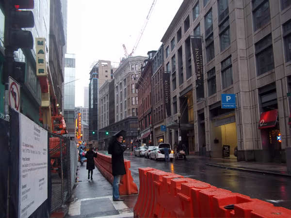
In the 1990’s economic conditions changed, and the demand for such an industry decreased, partially due to the availability of home entertainment. Today, there are only two remaining night clubs, the Glass Slipper and Centerfold on Lagrange Street (image 1). I believe the correlation between the lack of nature and the combat zone can be demonstrated in this image of Lagrange Street, the strongest remnant of the combat zone. The roads are poorly maintained and filled with graffiti today, and I suspect that this indifference for the environment was also displayed years ago. Ultimately, the red light district began to be commercialized and several apartment complexes began to be constructed. This construction continues today.
In summary, the nature of the Combat Zone did not promote working together with the forces of nature to develop the city. Few plants were grown, and additionally, no room was left for them to grow. Even though the town atmosphere has changed since the time of the combat zone, trees and gardens have not been made a priority. This could be because of the desire for more building development, or perhaps it is because the previous residents left no means for plants to thrive. Either way, it is clear that the social issues that were present in the area have left a lasting impact.

Image 1: Lagrange Street and its two remaining night clubs, Centerfolds and the Glass Slipper
Built on a landfill
Though social influences have shaped what is now easily visible today, it is important to note the environmental history of this section of town. This area, like several other parts of Boston, was built almost entirely on a landfill. At one time, Beech Street and Kneeland Street both ended with piers. As is apparent in the maps, the area I chose for my site was not completely filled in by land until around the 1840s (see Maps 1 – 4). I included images of maps from 1743, 1832, 1850, and 1948. On each successive map, the shore line gets a little farther away from my site. (The easiest street to look for in tracing the maps is Essex street).
The reason for filling in this land was because the small peninsula was slowing the municipal growth in the city (Spirn 15). It is interesting to note that thousands of years ago, earthquakes shaped the hills that were originally in Boston, and glaciers helped shape the rivers (Spirn 14). In more recent history, these hills are most often what provided the dirt to fill in these rivers, so that the city could be developed on a landfull. It is intriguing to see how nature originally formed the area, and how humans use it to continually reform the area: “In building and maintaining cities, human beings have assumed a dominant role as geological agents” (Spirn 91).
There is little to no evidence that it was built on water now, but it is clear that the street slightly slopes downward to where the water was. It is also possible to see seagulls flying overhead, another sign of the nearby water. The fact that the area is constructed on a landfill could have caused variable outcomes in its development: “In coastal cities like Boston, half the downtown may have been constructed on filled land, whose stability depends upon its content and the length of time it has been in place. Garbage, rubble, and wood of old wharves and sunken boats decompose at different rates and may cause subsidence for many years” (100). Therefore, the method in which residents created the landfill had an impact on what the city looks like today.

(Map 1, 1743)

(Map 2, 1832)

(Map 3, 1850)

(Map 4, 1948)
Nature Can’t Remain Hidden
As I observed on my trips through Chinatown, there appears to be little sign of nature’s influence. However, as I investigated further, I found that some trace of nature is present everywhere: “Nature in the city is far more than trees and gardens, and weeds in sidewalk cracks and vacant lots” (Spirn 4). The concept of nature encompasses animals, air, the water that’s used, and all elements of weather. For instance, there appeared to be wind guided between the tall buildings, as evidenced by the steam vent (image 2). This steam vent could also provide insight into how the city is heated. Otherwise, I didn’t notice too much wind on my visits. Perhaps this is because “Building peaks and street canyons, with their abrupt changes in shape, height, and orientation, place a frictional drag on the layers of air closest to the city’s surface, slowing them down”(Spirn 51). Even though these breezes do not seem to make a huge environmental impact, it is just another element that proves that nature and the city are intertwined.
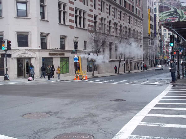
Image 2 (steam vent)
Additionally, I found that road conditions showed aspects of how nature interacts with the city. There are slightly sloping roads that provide a way for water to drain (image 3). Additionally, the road is crumbled in certain parts and filled with potholes, which suggests what type of soil could lie underneath. I also tried to pay attention to traffic patterns and how they could be shaping the city. Because of the constant stream of traffic around the area, I suspect that there are some gases constantly in the air: “Poisonous gases hang in the air above the street and toxic dust coats the roadway and sidewalk. Cars, buses, and trucks congest the streets, accelerating and braking, emitting streams of carbon of carbon monoxide, nitrogen oxides, and bits of lead and unburned fuel” (Spirn).

Image 3: water drainage
The final thing regarding “hidden nature” that I looked for in the city was plant life. I found limited trees on my site growing from the earth, but a few more that have been “potted” and are growing because of a conscious effort. However, though they are not thriving, they are present.
Why Is There No Growth Now?
As observed earlier, I found there was hardly any soil in my site for plants to grow on. The area right now is a sea of buildings and concrete. However, older images from Google maps show that its possible for the area to sustain plant life. Additionally, the area is adjacent next to Boston garden, which proves that it at one point in time had fertile soil. Unfortunately, wherever things could grow, new development takes priority. One of the few trees on my site is located on the edge of where development appears to be occurring, and another appears to be surviving because it is in someone’s backyard (image 4).
Another reason that trees and plants are not flourishing (besides the fact that it is winter), is the current quality of the soil. “The ‘soil’ of a demolished building site consists of rubble and fill: chunks of brick or stone and bits of mortar, wood, glass, metal, and dirt. It is desiccated, highly compacted, contaminated with insecticides and pesticides, and contains little organic material” (Spirn). It has a cracked surface and the temperature of the soil is very dependent on the weather. Not many plants can survive in this territory. (And, ironically, the ones that can survive we deem to be “weeds”!) (179). (Image 4b)

(Image 4)

(Image 4b)
Right across the street from my boundary line of my site, there are a number of trees. They are located outside Tufts medical center and along that road, and seem to be well maintained. There are also a couple street trees planted along one of the busier roads in my site. (image 5). However, though they are planted there is no guarantee they will last: “It takes more than forty years for most trees to mature; yet in the city the average lifetime of a street tree planted today may be only ten years” (171). These plants must endure difficult conditions and often grow in a dwarfed condition (175).
I believe the prominence of trees near the medical center shows that there are economic influences impacting how a town interacts with nature. It costs money to maintain and cultivate trees in cities: “The current, dismal survival rate of urban street trees can be improved, but not without cost. Success is assured only if trees are selected from among appropriate species, planted adequately, and soundly” (Spirn). Urban soil has a lot of potential, but is underutilized (Spirn 122).

Image 5
Future
I believe the Former Combat Zone will continue to develop and improve its conditions, so that it is a livable and respectable part of the community. A few trees that exist in my site are growing in pots or raised pieces of land, which I believe shows the efforts to make the town more aesthetically pleasing (image 6). I saw this same technique is being used in areas of Boston Common as well. There are a few plants growing outside of the new apartment complex, which leads me to believe that this trend will continue with additional complexes (image 7). Also, there are several plants in every restaurant and various shops that sell flowers, so I believe eventually, this appreciation for growth will eventually be promoted outside as well. In the effort to redevelop this area, the importance of nature should come to be realized: “The social value of nature must be recognized and its power harnessed, rather than resisted. Nature in the city must be cultivated, like a garden, rather than ignored or subdued” (Spirn 5).

Image 6
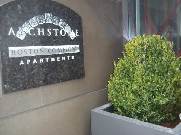
Image 7
Conclusion
In my research from maps and observations, several other questions were raised. For instance, I wondered to what extent animal populations influenced the city. I suspect there are a number of rats because of the numerous alleyways and dumpsters. I saw only one bird on the ground and no dogs being walked in 3 different visits to the site.
After researching Chinatown and concepts in “The Granite City” I came to understand the importance of integrating cities with nature. It affects every part of our lives. For instance: “The alteration of the city’s hydrology by pavement and sewers and their effect on both water availability and water quality had been recognized well before the twentieth century” (Spirn 139). I learned the importance of collaboration on issues as grand scale as city planning: “Professionals responsible for molding the actual form of the city, its buildings and spaces – landscape architects, architects, and engineers, seldom work at more than one scale. All too often, they either design specific buildings and parks without perceiving the cumulative effect upon the city and the region as a whole” (Spirn 240). Chinatown’s social issues have in a sense “fought against” the forces of nature in its development. These social issues, for example the need to reform the area, will once again shape the development, hopefully this time in a more productive manner.
Works Cited
"Boston Chinatown Banquet - Combat Zone." YouTube. YouTube, 10 May 2008. Web. 01 Mar. 2013.
"Google Maps." Google Maps. N.p., n.d. Web. 01 Mar. 2013.
"Search | The Norman B. Leventhal Map Center." Search | The Norman B. Leventhal Map Center. N.p., n.d. Web. 01 Mar. 2013.
Spirn, Anne Whiston. The Granite Garden: Urban Nature and Human Design. New York: Basic, 1984. Print.

