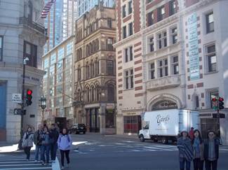
The area I investigated is bordered by Tremont St., Stuart St., Kneeland St., Harrison Ave., Essex St., and Boylston St., as depicted in the figure below. These borders include a slice of Chinatown as well as an area that was known as the Combat Zone in the 1960s to 1990s. My site was transformed over time by immigration, marginalization of the lower class, and advancements in transportation. Though it is difficult to present the area with a solitary explanation, the two pictures above are most representative of my site and give insights into its characteristics. The photograph on the left makes it evident that there is a diversity of layers in the city. An old hotel has been renovated to become an apartment building, a historic Young Men’s Christian Union building still stands, and a collection of commercial shops in a modern glass building have been built. The Young Men’s Christian Union still utilizes its original building and has a commemorative plaque. The picture on the right shows the recently opened Archstone apartments on the right side of the street. Meanwhile, on the left side of the street there is still ongoing construction. These two pictures demonstrate what is the most influential factors shaping my site today; a dichotomy of celebrating history and pushing for revitalization.
The preservation and celebration of history can be seen throughout the complex layers of my site. It is preserved in the traces of Chinese immigration, the remnants of the theater district, and traces of the combat zone. Clearly, this region reflected the course of American history in a number of dramatic ways. It was transformed from a manufacturing center to a theater district to a red light district in less than 150 years. David Harvey describes this dramatic process of overturning a city; “[It is] caused by changing material practices of production, consumption, information flow, and communication coupled with the radical reorganization of space relations and of time horizons within capitalist development “ (Hayden 43). These concepts are echoed in my site’s history, and continue to play an influential role in my site today. For instance, the changing “consumption” patterns reflected in an increased consumer demand for housing, has led to construction of apartment complexes on my site. Ultimately, though it is impossible to come up with a single story for the development of this area, exploring these themes helps to shape a picture of both historical and progressive influences on my site.

“Boston, Massachusetts.” Map. Google Maps. Google, February 2009. Web. February 2013.
- THE PRESERVATION OF HISTORY AND CULTURE
A prominent theme is pervasive in my site is maintaining history and culture. This concept manifests itself in the promotion of Chinese culture, preserving historical buildings, and allowing a select number of Combat Zone businesses to persist. As demonstrated in the first picture, there are a number of layers that exist and will continue to exist. All of these examples show that my site is an excellent example of social history being embedded in urban landscapes.
Chinese Presence
The most notable influence of my site is the Chinese presence. The Chinese population stands out because it is a distinct culture group in the middle of Boston. Tunney Lee, an MIT urban studies professor, highlighted important facts about the group to the public in a talk at the Boston Public Library. Tunney explained that first Chinese immigrants arrived in Boston in 1860 to break a strike. He also explained that they were often bachelors, and therefore seemed to have greater mobility. On the 1867 Sanborn map there are a number of factories that the Chinese would have been able to work in (Digital Sanborn). Additionally, a number of small buildings shown on this map could have served as apartments for these newcomers. The Chinese were able to make a home in this region presumably because living conditions near factories were not ideal, and therefore they were able to afford these homes. These small homes are not present today, but there are numerous small shops and restaurants that may have taken their place.
The Chinese influence is still very powerful in the area. A number of Chinese restaurants, bakeries, and gift shops line the streets, especially on Beach Street and Harrison Avenue. Other influences include Chinese advertisements on the street, a McDonald’s designed with a flair of Chinese architecture, and banks with their names in Chinese and English. Additionally, there is naturally still a strong Chinese population in the area.
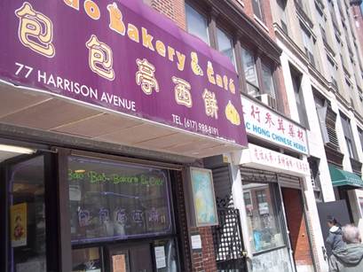
This is one of several bakeries within the borders of my site. It is located on Harrison Avenue
Respected People
It is interesting to note how maps and observations of the city have demonstrated a change in the attitude towards the Chinese people. For instance, between 1867 and 1895, Harrison Avenue at the south edge of my site was widened so that it cut off numerous buildings and homes of Chinese residents (Digital Sanborn). This action demonstrates the negative attitude towards immigrants and that the ability to marginalize them as a people group shaped the city.
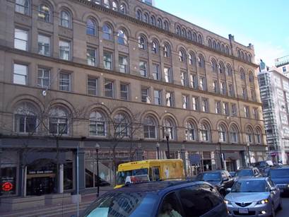
However, according to a 1992 Sanborn map, a China Trade Center had been created. Therefore, over time, the Chinese people have become an influential and respected group in society. Below is a picture of the building to this day. It still retains the name “Boylston Building” as it has for years on the top. This building was evident in the 1867, though it was called the Boylston market. In the 1895 Sanborn maps, it shows the name has been changed to the Boylston building. This picture represents an interesting mix of historical tradition and also the promotion of the Chinese people. I believe that this trend will continue and the Chinese will become more vocal in Boston politics.
Historical Buildings & Signs
There are a number of other historical buildings on the site that are not a result of Chinese immigration. Analyzing these buildings, and the motivations behind them, is essential for a complete understanding of the region. Camille Wells explains that “most buildings can be understood in terms of power or authority- as efforts to assume, extends, resist, or accommodate it” (30). This is the case in this section of Chinatown; the Boylston Building/China Trade Center is one such example of how buildings reflect who is in power.
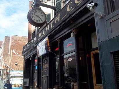
Some buildings in the area have plaques on them, which are artifacts that represent society’s recent values of preserving history. The picture below for instance, is a historical restaurant. The plaque on the building explains that the restaurant was founded by Jacob Wirth, who was an Irish immigrant. He began serving food in 1868, though he moved his restaurant to this location several years after he began. His family carried on the tradition and the nineteenth century interior of the building remains intact. These buildings are the only remaining ones of the bow-front Greek Revival rowhouses that used to control the area. Wirth expanded his building in 1889 to encompass the property next door. This building is an excellent example of preserving history on the site. It also gives insight into the several other immigrant groups that shaped the town in the past.
Another prominent building that is recognizable is the Young Men’s Christian Union, which is located on Boylston Street. The first time this institution shows up in my maps is 1895, though the plaque indicates that it was founded much earlier: “Nathaniel Bradlee designed this outstanding example of High Gothic architecture in 1876”. Though it was built in 1876 after the fire of 1872, it was formed by Harvard students in 1851. They used the organization as a religious support group, and it eventually became used as a social and intellectual organization for men as well.
The area also has a number of patriotic artifacts including street signs that honor fallen officers. For instance there is one that reads “Lieutenant Inspector Benjamin Alexander, Killed in the Line of Duty, 1925”. There is a plaque on the “Commonwealth of Massachusetts Registry of Motor vehicles” building that reads “Sons of Livery 1766; Independence of our Country 1776”. There is a similar dedication on the ground outside the China Trade Center building as well. Each of these artifacts demonstrates the desire to safeguard historical events.
Traces of Theaters
There are certain phenomena that I found striking as I walked around my site. In the years 1929 to 1992 on the Sanborn maps, there are 3 large theaters on the site (Digital Sanborn). The presence of these theaters was presumably a large influence in the construction of parking lots and parking garages for the area. However, walking around the city today, it was nearly impossible to detect where the theaters had been without the maps. Even the small roads that led to their entrance were blocked by construction or a fence of some sort. I came to understand that the space of the city is very complicated. Henri Lefebrve explains some complex characteristics: “Space is permeated with social relations; it is not only supported by social relations but it is also producing and produced by social relations” (40). Therefore, the certain relations that encouraged the development of the theaters also contributed to their demise.
Nonetheless, I was able to find small traces of the theaters. A sign on the corner of Stuart and Washington said “Theater district”. There is also an artifact in the form of a large “ticket” arrow sign that is no longer functioning. It points to a pub on Tremont St., which is presumably not used for ticket sales anymore. It is also important to take the site with the context of what is around it. Though the three theaters that were part of my site disappeared, there were and still are a number of theaters in neighboring blocks. Therefore, I believe that my site did not focus as much attention on preserving since there were still others close by.
Combat Zone Remnants
The Combat Zone was a huge obstacle the Chinese and surrounding communities had to face. The Combat Zone was an area of crime and adult entertainment that was mainly concentrated on Washington Street and Lagrange Street (Lee). It was developed in the 1960s and lasted until the 1990s. It was an area filled with prostitution, gangs, and several strip clubs. The theaters were transformed into a business for sexual entertainment. This area formed because the City Hall had been redeveloped and the crime that was centralized there had to move to another place (Lee). Because of this, crime was able to manifest itself near Chinatown. Again, this is because I believe that because the Chinese were not given an equal voice in society and did not have any power to fight the changes.
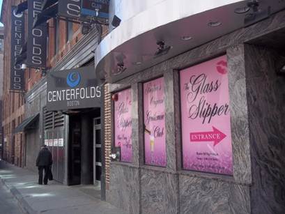
Though it is hard to detect the remnants of such an area on historical maps (Digital Sanborn), it is easy to see some of the remnants first hand. For instance, below is a picture of the two remaining night clubs on Lagrange Street. Additionally, there is a sex shop remaining on Stuart Street. Except for these few businesses, there are essentially no traces of the combat zone.
All of these examples prove that this area of Boston has a variety of ways it respects its history; it respects immigrants, patriotism, and even the more recent adult entertainment businesses.
- RENEWAL AND REVITAILZATION
Combat Zone Revitalization
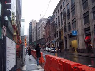
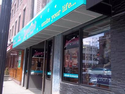
The ending of the combat zone appeared to usher in period of reconstruction and revitalization, which is still going on to this day. Once the “combat zone” descended on the town, the theaters began to be used for adult entertainment (Lee). This is one hypothesis as to why they no longer appear today; they were shut down in order to reshape the city. For instance, below is where an entrance to a theater once stood. However, now it has been developed into Archstone Apartments, a large complex that seems to attract wealthier citizens.

Construction
Archstone Apartments is not the only new housing development in the area. On the corner of Tremont St. and Boylston Street an old hotel has been refurbished into new apartment style housing, as referenced in the first picture. The Kensington, another housing development, is being construction on Washington Street, slightly down the road from the Archstone apartments.
Construction is underway on almost every street in my site, which clearly demonstrates a strong trend of revitalization. Below are two images that highlight how fast my site is developing. On the left is a photograph that I took in February of 2013. The image on the right was taken in early April, less than two months later, from approximately the same place. You can match the photographs by comparing the graffiti of a red triangle in each. The difference in the landscape shows how quickly the site is developing. To summarize the expanse, there is construction on Washington Street, Lagrange Street, Essex Street, and Stuart Street.


Trend: These Empty Buildings won’t be here long
In addition to the amount of construction on my site, there are also a number of empty buildings or stores. However, based on the amount of construction in the city, it seems that these will not be here for long. The new housing developments should bring in more consumers to the area, and therefore these buildings will fill with more shops. The trend of growth and renovation will continue quite some time into the future.

Conclusion
All of these examples have demonstrated the competing influences of my site. There is push on my site to recognize and respect events of the past. This is demonstrated by memorials, historical buildings, combat zone remnants, and the continuing influence of the Chinese population in Boston. However, there is also a competing influence to rebuild the city in an effort to erase the negative effects of the combat zone and become an economically stable section of the city. The trend will continue, and history will continue to weave the two influences together in the future.
Works Cited
Digital Sanborn Maps 1867 - 1970. N.p., 2001. Web. Mar. 2013. <http://sanborn.umi.com/cgi-bin/auth.cgi?command=AccessOK&CCSI=254n>.
"Google Maps." Google Maps. Web. 01 Mar. 2013.
Hayden, Dolores. The Power of Place: Urban Landscapes as Public History. Cambridge: MIT, 1995. Print.
Lee, Tunney. "Boston's Chinatown: Beyond Stereotypes, Food, & Boundaries." Boston Public Library, Boston. 13 Feb. 2013. Lecture.