 Close-up map of site
 Site within downtown Boston.
Bounded by Summer Street, Bedford Street, Arch Street, Milk Street, Congress Street, and Atlantic Avenue, my chosen site consists of South Station, a part of Boston’s Financial District, and a small segment of the Big Dig Project. The diverse set of land uses included in this particular site posts many questions and is a classic showcase of how commerce has shaped one of the most historic cities in America.
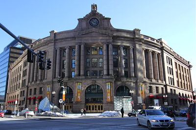 Front view of South Station
I start my exploration of this area at South Station, one of Boston’s transportation centers with two MBTA lines, a major bus terminal, and one of the city’s two train stations. The contrast between the North Station and South Station immediately catches one’s attention. North Station gives a utilitarian outlook with its warehouse-like exterior, whereas South Station is in the style of neo-classical architecture, as seen in its symmetry, stone façade, and curving walls. The station stood outstandingly facing the intersection of Atlantic Avenue and Summer Street. For centuries, railroad was the most prominent mode of long distance transportation; and the Boston South Station became the busiest station in the United States in 1910, a mere 11 years after it was opened (4). South station and its relationship with its surroundings post many interesting questions – How was the station site chosen? How has it influenced the neighborhood around it? What was neighborhood like before and after its erection?
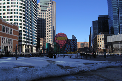 The Greenway and the Big Dig project
The Big Dig project and more specifically, the Thomas P. O’Neill Jr. Tunnel, crosses in front of South Station. Officially known as the Central Artery/Tunnel Project and unofficially known as the Big Dig, this mega project rerouted Interstate 93 underground into a tunnel and reshaped the outlook of the city (2). A combination of drastically escalated costs, design flaws, execution errors, and other scandals made the project one of the most controversial in Boston’s history of urban reconstruction. On weekdays, many food trucks and small vendors would set up on the formal I93 site, serving the white collar community working at the Financial District. On a wall facing the site, there is a giant mural portraying a girl sitting down in the cold; I wonder if the mural has a story behind it. It would be fascinating to compare the neighborhood before and after the Big Dig project and see how it has impacted the area.
 Site within downtown Boston.
 Winthrop Square in the center of Financial District
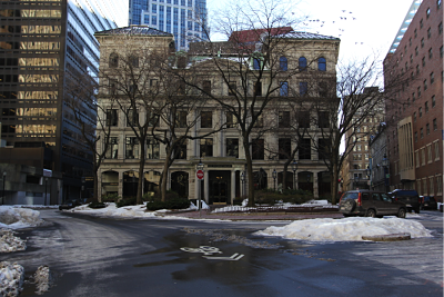
A particular interesting area in the site is the Winthrop Square near the intersection of Otis Street and Devonshire Street. These two streets and an unnamed street intersecting both of them form a rectangle. This triangle formed by the streets, Winthrop Square which sits immediately behind it, and the small “jewel-box” style office building One Winthrop Square in the back of the Square appear to be an anomaly in the center of the Financial District. Furthermore, a statue of the esteemed Scottish poet Robert Burns stands notably in the center of Winthrop Square (1). I expect to find an intriguing story behind this triangular irregularity and its relationship with Robert Burns as I research the history behind this site.
Winthrop Square in the center of Financial District
A particular interesting area in the site is the Winthrop Square near the intersection of Otis Street and Devonshire Street. These two streets and an unnamed street intersecting both of them form a rectangle. This triangle formed by the streets, Winthrop Square which sits immediately behind it, and the small “jewel-box” style office building One Winthrop Square in the back of the Square appear to be an anomaly in the center of the Financial District. Furthermore, a statue of the esteemed Scottish poet Robert Burns stands notably in the center of Winthrop Square (1). I expect to find an intriguing story behind this triangular irregularity and its relationship with Robert Burns as I research the history behind this site.
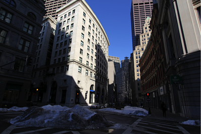
Looking at the site in Google Map view, the curvilinear streets form a natural layout, distinct from the popular grid pattern. The upper-left portion of the site consists mostly of one-way streets and loops. These one-way streets also make up the majority of the Financial District, contributing to Boston’s notoriety as an undrivable city. The streets in the site are in general wider and flatter in comparison to the older parts of the city. The street formations tell a story of how the city evolves around older structures even if these structures have ceased to exist.
In summary, the site located at Dewey Square and Financial District encompasses a variety of land uses and showcases how downtown Boston is shaped by historical events. The site posts many questions in what forces might have influenced its evolution and how the city transforms itself around commerce and transportation. I look forward to learning more about this site and its history throughout the semester.