Walking through Downtown Boston, a landscape that is almost entirely covered by pavement, brick, stone, concrete and glass can trick you into thinking that nature has been conquered by men: first with the horses, carriages and shovels that allowed early settlers to mine hills and build their own environment out of brick; now with bulldozers and cranes that erect 40-story skyscrapers. But in reality, you are surrounded by sometimes subtle, yet ongoing processes that have shaped the metropolis since its founding. Downtown Boston is a very busy district whose thorough development, poor air quality, heavy traffic, and littering appear to have stifled many life forms and covered up any natural resources that may have originally been there. Thus, there is simultaneously conflict and collaboration between the winds and waters and among the plants, creatures and humans that occupy downtown Boston. The average corporate American, commuting to and from a Downtown office building, may not notice these patterns. However, upon closer inspection, there is ample evidence that the seemingly pervasive human constructs were and are affected by other life forms, climate and topography.
When evaluating the environmental context of this site in modern Downtown Boston, it is useful to consider its original, pre-settlement characteristics. It was a part of the original colonial settlement, chosen because of its strategic position near the shore, relatively flat topography (compared to the Trimountain to the west), and access to fresh spring water. Even as humankind has filled coastal land, flattened many hills and polluted/depleted the water, there is still some indication of the neighborhood’s history. Although the spring that once satisfied the thirst of colonists has since been paved over, the current names of Spring Lane and Water Street hint at the history of their original fresh water supply. Today, there are two plaques on these streets. The one on Spring Lane, a mere alley, reads: “Here was the Great Spring which for more than two centuries gave water to the people of Boston.” The other tells a richer story: “The excellent spring water on the Shawmut Peninsula drew the Puritans to settle here. The site of the spring is marked on Spring Lane. Nearby the colonists built their compact town. The first church, first market, first prison, first burying ground, and the house of the first governor all stood close together. Today, two major landmarks, the Old State House and King’s Chapel, stood on the edges of the site of the early town center.” However, as the town’s population increased, the private wells and municipal water source were insufficient to meet demand. Further, many were contaminated by toxic waste. This environmental change forced Bostonians to look for water outside of their city’s boundaries and to flood a valley in order to create a reservoir [1]. Since then, the growth of Boston has continued to be shaped by changing natural processes.
“The city is neither wholly natural nor wholly contrived. It is not ‘unnatural’ but, rather, a transformation of ‘wild’ nature by humankind to serve its own needs” (Spirn, 4). Car exhaust and other urban pollutants may mask the freshness of air that is normally considered natural, but Downtown Boston is still subject to the force of wind that can be felt in open fields or on top of mountains. Luckily for native Bostonians, sea breezes and the winds over the Charles River freshen the city air somewhat. Conversely, the air feels the impact of human habitation; wind is redirected by the buildings that reach upwards from the center of the city. Often, the wind patterns in an urban environment are more complex than they would be without the tall networks of buildings obstructing and channeling the wind into jets and eddies.
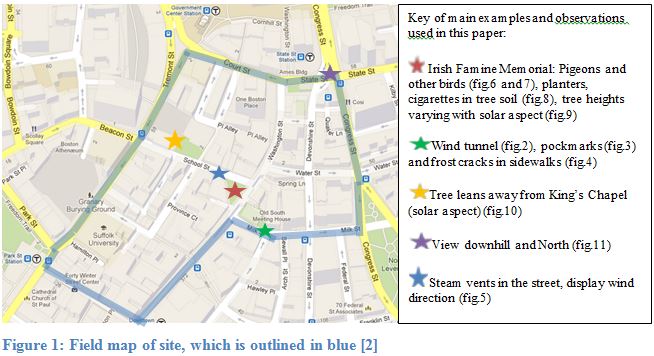
Overall, cities “have reduced wind speeds, overall, but accelerated speeds in some areas” [3]. When I visited my site, winds at Boston’s airport were gusting at a relatively calm 6 MPH from the Southeast [4]. In general, the winds in Downtown felt consistently calm, but in a few places, it was obvious that building orientations were causing wind to speed up and create windier, colder microclimates. As Anne Spirn describes, “numerous office towers downtown… catch wind and send it swirling down to the street” [5]. This effect can be exacerbated by the narrowness of some streets. One such example is pictured below, in Figure 2. This parking garage and adjacent pedestrian walkway appeared hazy from a distance (so I could see some ripples from jets of wind). Even though it was right across the edge of my site’s boundaries, I went to take a closer look. Once I entered the pedestrian walkway, I immediately felt the air chill and the wind blowing my hair around my face. This is just one clear example of the way in which human structures can create microclimates that otherwise would not exist.
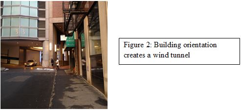
The chill of some streets’ extra windiness, combined with the harsh New England winter, create safety and comfort concerns for the Downtown neighborhood. All Boston curbs provide a clue to the city’s climate, since they are made of enormous slabs of sturdy granite, in order to withstand the impacts of snowplows. Figure 4 shows cracks in a granite sidewalk slab, which I hypothesize were caused by repeated freezing and expansion of water (i.e. “ice/frost wedging”) during the winters. Although granite is very durable, it is still porous and subject to this effect, especially over a long period of time. Frost wedging is a clear indicator of distress caused by the frequently changing weather of Boston. Perhaps in an attempt to prevent slipping on slick stone in dangerous weather (i.e. windy, rainy, and/or icy conditions), a sidewalk on Milk Street is strangely texturized with pockmarks (figure 3). Many of these streets and sidewalks are also coated in the remnants of salt that was poured on ice to defrost paths. This salt residue hints not only at the climate, but also at the associated groundwater and soil contamination [6]. With this cold climate also comes increased demands for fuel. Figure 5 shows steam, perhaps from cogeneration of heat and power, escaping through holes in a street manhole cover. This is a clue of the hidden infrastructure that has been built in response to the difficult climate of Boston.
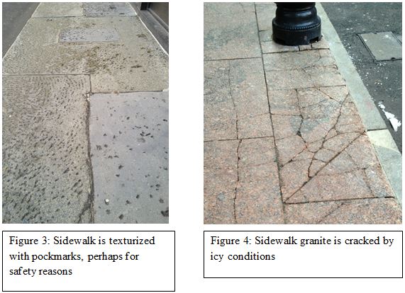
The steam shown in figure 5, below, also allowed me to measure the wind direction on School Street and to compare it to the wind direction measured by the National Weather Service at Boston Logan Airport. While the airport measurement was at approximately 135 degrees (SE), this steam was consistently travelling down School Street at 102 degrees (E) for the entire span that I observed it. It seems that, even though the buildings on either side of this part of School Street would not be considered skyscrapers (they are all less than ten stories tall), their orientations have forced the wind to change from its natural path. Certainly, the variety in building heights in Downtown Boston – a consequence in the diversity of building ages – adds an additional layer of complexity. Without any device to measure wind speeds, I was unable to precisely analyze their variability. However, State Street (near the cluster of skyscrapers that includes One Boston Place), did feel windier to me than School street and the southern segment of Washington Street, where the buildings are much shorter
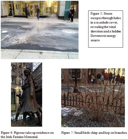
Near the steam vents in Figure 5 are several tourist attractions, and therefore some busy streets. There is an open plaza-like area containing benches and the Irish Famine Memorial, an example of an outdoor space that has been poorly placed: “busy city streets are not suitable locations… until the streetside air is improved or unless the area is well ventilated and set back from the street” [7]. Figures 6 and 7, above, are from the Irish Famine Memorial, where birdlife flaps and hops among the statues and barren bushes. These birds were the only evidence of animal life that I could observe in the middle of a winter day. I suspect that at night, other city creatures emerge, including rodents. However, it is also possible that the density of human development has driven even the small animals from this district, or at least that humans have forced these animals to roam basements and alleyways instead of the main streets and plazas. Another possible explanation for the absence of animals is the active pest control efforts of local residents and business owners.
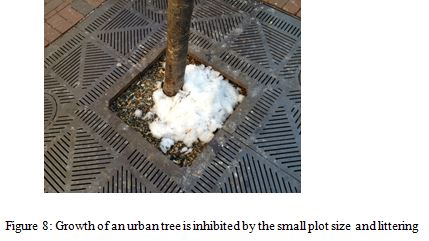
The Irish Famine Memorial and its surrounding plaza also house tended plant life, including beds of soil with shrubs, potted ornamental plants and street trees. The habitats of the street trees especially are very hostile: Figure 8 shows a skinny, scarred tree in a small patch of compacted soil, surrounded by metal and brick. What little soil it does have is being used as a communal ash tray, which is surely toxic to the pitiful tree. Landscaping maintenance budgets are declining and city-dwellers are clearly negligent; it is no wonder that street trees live to be only ten years old, when their age of maturity is approximately 40 years [8]. This site in Downtown Boston substantiates Spirn’s claim that, in city plant arrangement, there has been more emphasis on fashion than on utility [9]. The poor (and still declining) overall health of urban plants has great implications for the community, beyond the associated decline in property values and aesthetic appeal that residents seem to prioritize. Trees are important oxygen producers, which dilute the toxins in the air and make it healthier to breathe. They moderate temperatures by providing shade, absorb water (and thus mitigate flooding), improve water quality and use their roots to slow soil erosion. This is a critical example of a way in which humans could and should be mindful of the needs of trees, since the relationship is so mutual and could benefit from cooperation.
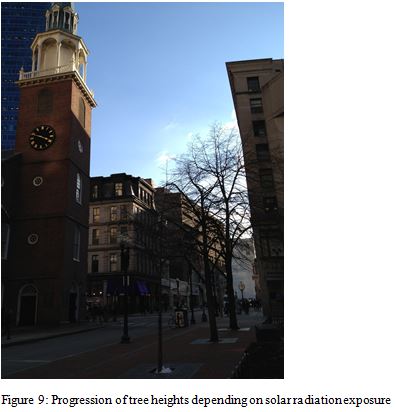
Another factor influencing the growth of street trees is solar aspect. Buildings lining city streets effectively create valleys, which cast the North-facing side in shadow and expose the South-facing side to more solar radiation on average. Figures 9 and 10 show the two major ways in which trees react to the sunlight differential. In some cases, as on the N-S trending Washington Street (in front of the Old South Meeting House in Figure 9), trees that receive less sunlight will simply not grow to be as tall and thick as those that receive more. The smallest tree, in the foreground of the photograph, faces North and is overshadowed by tall buildings nearby. The next tree back is bigger, and the furthest one back faces South and receives the most sunlight, so it is the largest of the three. Thus, the placement of trees in relation to buildings has a tangible impact on how healthy the tree will be, how grand it will look and how much shade it will provide. It appears that the urban planners near the Old South Meeting House were hoping for three similarly-sized trees, but the shadow cast by the surrounding development made this unrealistic.
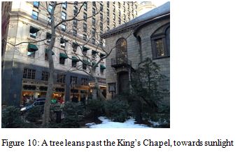
Above, Figure 10 shows another possible way that trees respond to lack of sunlight. This tree is reaching over the street, past the King’s Chapel, which is blocking its sun exposure. As it leans towards the open space, it is able to grow to be larger. However, this can present problems for the city if the tree were to be damaged by a storm and fall into the street, or if wind were to drop piles of snow from the branches down onto an unsuspecting car driver below. Still, it is arguably better that some trees are able to survive by responding to the harsh aspects of the environment that humans have constructed around them.
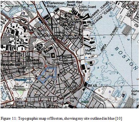
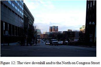
Earlier in this paper, I called the topography of Downtown Boston “relatively flat compared to the Trimountain in the West.” As Figure 11 shows, it is not completely flat, since parts of my site are on the slope of Beacon Hill. The grade is not very steep, but it is certainly still not flat. This should be associated with other natural dynamics, such as water’s flow downhill and wind’s interaction with the top of Beacon Hill, but since it was not raining when I visited my site and since the western boundary is not very far up the hill, I was not able to observe these phenomena firsthand. I did observe the view North on Congress Street, shown in Figure 12, which is noticeably downslope. The fact that Downtown Boston is not as flat as the land fill parts of Boston probably speaks to its importance over time. When it was originally settled, the colonists likely did not need it to be perfectly flat, and Downtown Boston has been inhabited ever since. Clearly, developers have been able to build on the somewhat uneven land, and I suspect that many of the plots that hold skyscrapers have been leveled, but overall the heart of the city is on a slope.
Whether you look to its relationship with water, air, life, or Earth, Downtown Boston is not an isolated creation of humanity. Since its settlement, it has buried and removed some aspects of the natural environment that existed before colonists arrived. Meanwhile, the climate, animals and trees that we see and experience today have adapted to the urban jungle, which has not demolished the environment, but rather created a new one.
Bibliography:
[1] Spirn, A. (1984). The granite garden: urban nature and human design. New York: Basic Books, 25
[2] Boston, MA. (27 Feb. 2013). Sanborn and Google Maps. Google. Retrieved from https://maps.google.com/maps?q=8+Tremont+St,+Boston,+MA&hl=en&ll=42.359131,-71.059635&spn=0.009355,0.024397&sll=42.357237,-71.057972&sspn=0.001665,0.00305&oq=boston&t=h&hnear=8+Tremont+St,+Boston,+Massachusetts+02108&z=16
[3] Spirn, A. Urban Climate [PowerPoint slides]. Retrieved from https://stellar.mit.edu/S/course/11/sp13/11.016/courseMaterial/topics/topic3/video/urbanclimate.m4v_(video_x-m4v_Object)/urbanclimate.m4v_(video_x-m4v_Object).mp4
[4] Boston, MA. (25 Feb. 2013). National Weather Service. Retrieved from http://forecast.weather.gov/MapClick.php?lat=42.3584308&lon=-71.0597732&site=all&smap=1&searchresult=Boston%2C%20MA%2C%20USA
[5] Spirn, A. (1984). The granite garden: urban nature and human design. New York: Basic Books, 28
[6] Ibid., 104
[7] Ibid., 58
[8] Ibid., 171
[9] Ibid.
[10]Boston, MA. (24 Feb. 2013). NGS USA Topographic Maps for Google Earth. Retrieved from http://services.arcgisonline.com/ArcGIS/rest/services/NGS_Topo_US_2D/MapServer