Having grown up in central Connecticut, I cannot even remember the first of many times that I visited Boston. But I do remember walking the Freedom Trail and being enchanted by more than just the centuries of history. I loved the detailed facades and I was fascinated by the way that the streets wound around each other. It wasn’t until my Introduction to Geology class at MIT that I returned to the parts of the Freedom Trail that I walked as a child. The course included a field trip called the “Boston Rocks Walking Tour,” an excerpt of whose route I have included in my site’s boundaries.
More specifically, my site begins at the intersection of Tremont Street and Winter Street (by the Park Street T station). It extends northeast along Tremont Street, past the Suffolk University building and the Granary Burying Ground. Taking a right onto Court Street (which becomes State Street) and passing by the Old State House, continue until Congress Street. Take a right and go until part of Norman B. Leventhal Park (recreational space) can be seen on the left. Turn right onto Milk Street, then take a left after the Old South Meeting House (a museum that used to be a government building) onto Washington Street and walk southwest to the Downtown Crossing T Station. Take a right onto Winter Street (which is predominately lined with shops) to complete the Southern border. This street ends at Tremont Street and by the Park Street T Station (Figure 1). I chose these boundaries in order to include as many of the oldest buildings in Downtown Boston as I could in a space that looks to be approximately 8 city blocks. However, I did have to be a little creative with the shape since this district does not really have any blocks.
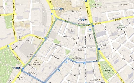 Figure 1: Street map view of site, which is outlined in blue. Image from Google Maps.
One main motivation for my site selection is the variety of building materials there, unlike some of the other districts of Boston that are much more homogenously brick or brownstone. I also chose my site because I believe that it is one of the “epitome districts,” defined by Grady Clay as a place that carries “huge layers of symbols that have the capacity to pack up emotions, energy or history into a small space.” It bustles with activity, even on a frigid February afternoon. Tourists stop in the middle of paths to take pictures of museums, churches and statues. In addition to those destinations, this one district contains almost every type of urban land use: residences, tall office buildings, many shops and restaurants (like the Ruth’s Chris in the Old City Hall), hotels (including the oldest continuously running hotel in America, the Omni Parker House) and the Orpheum theater.
There are a number of questions that come to mind: What stories can I uncover in the juxtaposition of 18th century historical sites against modern skyscrapers; graves of revolutionaries next to subway stations? How can I understand the reasons for the eclectic mix of building materials found here, including sandstone, Indiana limestone, at least six different types of granite, Carrara marble, brick and reinforced concrete? How can I explain the seemingly disorganized streets that curve and intersect at oblique angles? I know that, in order to allow Boston to expand, Mill pond to the North was filled in and some nearby hills were flattened, so how did this impact downtown Boston? I suspect that these last two questions may be linked, since Grady Clay describes “breaks,” as places where “street[s] laid out across flat land encounter a steep hill or a valley; or else where … [streets] clash [and] there usually emerges a series of awkward, irregular and angular street junctions” (43). With more careful study, I hope to answer all of these questions this semester and to satisfy the curiosity that I felt back when I visited downtown Boston as I child.
Bibliography:
“12.001 Field Trip 1: Boston Rocks Walking Tour 2011.” http://ocw.mit.edu/courses/earth-atmospheric-and-planetary-sciences/12-001-introduction-to-geology-spring-2011/field-trips/MIT12_001S11_BoRo2011.pdf. Accessed February 17, 2013.
Clay, Grady. Close-Up: How to Read the American City. The University of Chicago Press: Chicago, IL. 1980: pp. 11-16, 38-65.