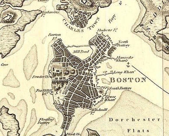
 A picture of Boston c.1800.
The Early Years of East Cambridge
By 1814 Lechmere Point was forming into a small town, this becomes more apparent when maps of later in the 1800s are examined.
 A sign from the Cambridge Historical Commision, dating the courthouse to 1814.
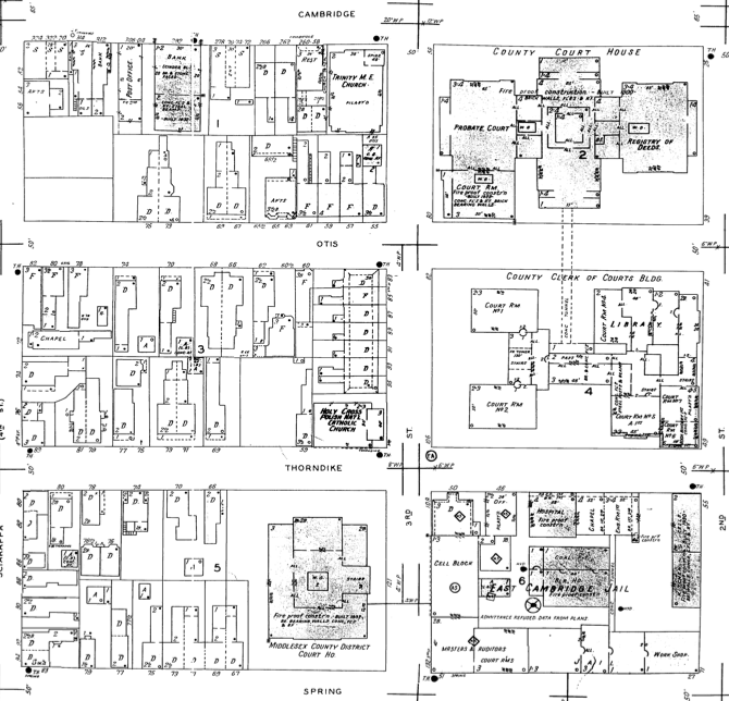
This sign found in the still existing courthouse is proof of some of the earliest establishments in Lechmere Point. This sign also helps to set a trend for how this area changed over time. By examining more maps of the area in the early to mid-1800s one can start to see how the area developed. In the image below,
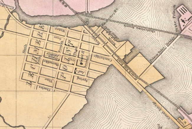 A zoomed in photograph of Lechmere Point in an 1839 map of Boston and the surrounding area.
> Lechmere Point has begun to prosper as a small town, a bridge has been built connecting it into Boston, enabling it to grow and change much quicker. From this image of Lechmere Point, some of its key features begin to take form, the grid like setup, which is absent in many of the earlier developed areas of Boston, begins to appear. The Middlesex County Jail is established, along with the courthouse and several other small buildings. In this map of 1839, the street names can be seen which will remain almost identical through present time. The grid layout that is established by 1839 is the same grid that currently shapes East Cambridge; however, one thing that is not depicted in this map is some of the elevation change that is still present in this area. A trip through these streets in the present day show the hills that lay under the asphalt, prior to proper paving of these streets one can only imagine the elevation changes in this area must have been greater and affected some of the housing arrangements of the citizens that resided here.
Housing In the earliest Sanborn map available for this area, 1900, the same grid structure presented in the 1830s maps is still present. The Sanborn map provides more insight into what was going on in these blocks of land.
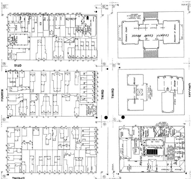 The entirety of my site depicted in 1900 by Sanborn Maps.
The set of images above depicts the entirety of my site in 1900. It becomes clear that by 1900 the area of Lechmere Point had been established as a small town and was transitioning more into a suburb of the greater Boston area. By 1900, residential buildings were very prominent in Lechmere Point; the Sanborn map shows how many of the residential blocks were beginning to have buildings compacted together to create more available housing. When comparing these housing arrangements to current maps,
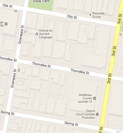 The current layout of my site as depicted on Google Maps.
it becomes noticeable that many of the original property lines did not change. The present day Google map above shows some of the building outlines that, when compared to the 1900 Sanborn map, have changed which indicates that new buildings have been created in the same space where buildings stood in 1900. For a residential area this shows the natural progression that occurs as new building techniques are discovered and more efficient buildings are built. When comparing the 1900 Sanborn map to a 1934 Sanborn map, pictured below, more buildings begin to appear within the same space. This is due to the increasing population of Boston and of its surrounding areas; however, due to the insufficient amount of land in the surrounding area of Boston many locations, such as this, became more densely populated. The residential layout of the area stayed fundamentally the same through the present day with the blocks encompassed by 4th St (Thorndike St), Cambridge St, 3rd St, and Spring St.
 Another Sanborn Map of my site, this time showing the area in 1934.
The above map of East Cambridge in 1934 shows minor changes compared to the Sanborn map from 1900, more buildings were added into the residential boundaries, which accommodated the growing population of the area. This is even further evident with the current layout of East Cambridge as residential buildings have grown upward and larger. Another indicator of the growing population of East Cambridge is the emergence of a larger bank and a post office on Cambridge St. The size increase in the bank building shows that more people were moving in and a greater amount of commerce was present in the area. The addition of a post office also signifies a growing population; East Cambridge was growing towards a more independent town with more activity occurring.
>
Places of Worship and Their Decline
Another point from analysis of the Sanborn maps is the decline of religious influence in the area. In the map from 1839 some of the religious centers are marked off with black highlighting. Most of these buildings are places of worship by 1900 when the first Sanborn map gives more information of their religious affiliation and gives for a better understanding of the buildings.
In the 1900 maps, there are approximately 4 different religious buildings all offering a variety of religions. The diversity in religion reaffirms the growing of this region, by offering a multitude of religions in the area more citizens would be inclined to move out of Boston and into the surrounding land. However, by 1934, some of the buildings had been repurposed and by present day, many of the buildings do not exist. This is of high interest because in most scenarios religious buildings do not get torn down, only repurposed. The disappearance of these buildings only lead one to believe in a decline in the influence that these religions had; however, the area continued to be prosperous and continue to grow. The Trinity Methodist Church that stood on the corner of Cambridge St and 3rd St is the best example of this decline in influence. In 1934 the building stood in one of the main corners East Cambridge; however, in a present day map, this location is now a parking lot.
>
Middlesex County Jail
The Middlesex County Jail is currently one of the more prominent buildings now in East Cambridge. This jail is also indicated in the some of the earliest maps for this area. In a map of Lechmere Point in 1836 the jail is very clearly marked; in all of the following maps to date the jail is a very prominent feature of the area. The jail becomes more interesting as the surrounding area becomes more residential in the mid to late 1800s. In present day maps, the jail is still one of the more iconic buildings in the area. The jail as it currently stands was built in 1971 with the intent of being a multipurpose building. This increase in judicial activity occurred at similar time to the decrease in religious centers in the area. As the religious influence of the area declined and judicial business increased many of the related work also moved into the area. In present day, Eat Cambridge, the amount of law offices in the area has increased greatly. This increase in jobs associated with the increase in judicial buildings also occurs when the area becomes more densely populated.
>
Remnants of the Past
Although East Cambridge has not changed significantly in its layout of buildings, the area has undergone several shifts. From as early as the 1830s, East Cambridge had been established in a grid pattern with a strong residential section, and a judicial center. As one walks around this area its historic significance is still very present with the large brick judicial buildings. The religious center it once was is now a shadow in the quiet suburbia it has become. The downtown that once existed on Cambridge St is now sparsely filled with shops. East Cambridge still alludes to the town it once was, but the clues are subtle. As Cambridge and the biotech industry keep growing, the push into East Cambridge will occur, and then another layer will overshadow the history of the area. The residential aspect of East Cambridge has proved to be something that will not change, the original layout and property boundaries have proven effective at keeping it as such.