Boston grew significantly from the early 1800s to the early 1900s and therefore it expanded its borders to new areas. The First Church of Christ Scientist land area, located on the Back Bay, went through the faces of becoming a new plot of land, to suburb of Boston, and finally to a part of Boston. In the mid-1800s the expansion pushed Boston’s borders towards the south and west. The figure below shows the 1858 view of the Back Bay from Boston; it can be seen that the land has not been filled. The land filling was finished around the late 1880s and early 1890s. This was all new land ready for new buildings and roads.
As I looked through the maps of my site, the church seems to have more dramatic changes so I will try to focus more on this section. I have separated the maps into five different years: 1887, 1897, 1937, 1951 and present.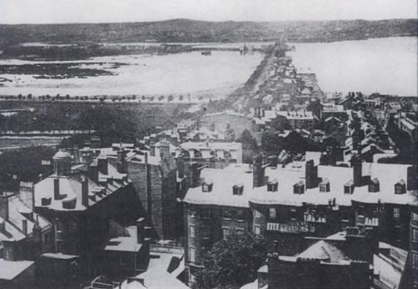
1887: New Land
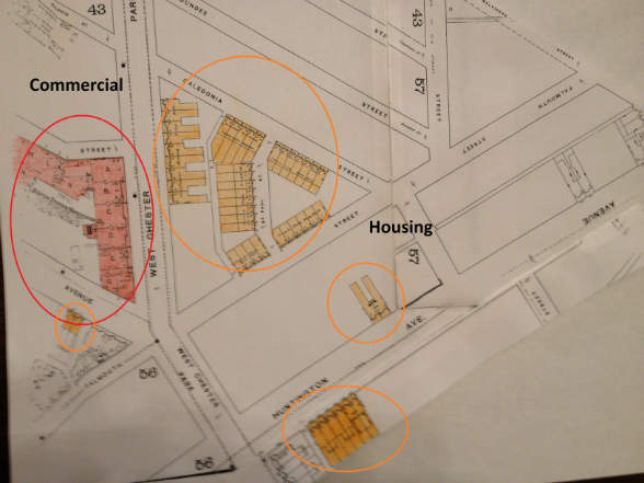
Because the Back Bay was finished in the 1880’s, it is not surprising that only a few buildings have been established. The 1887 Sanborn Map shows the few buildings and they all seem to be concentrated along one area, rather than spread out throughout the site. The buildings seem to be concentrated in the section where the church is located now, and in the block across from that. At this point, there is still no church. Almost all of the buildings are apartments (orange). This is currently a suburb of Boston and like most suburbs, it starts growing by introducing housing. Most of the apartments are close together and located in the triangle shaped block in the center of the site. This suggests that the apartments are probably owned by one or few owners. The location of these apartments is advantageous for the owner because the apartments are bordered by three streets allowing incoming citizens to easily spot them. This is the intersection of many streets so people will pass by this area a lot. There are some scattered around in the southern and western part of the site which suggests that they are probably owned by a different owner. The storage warehouse in this site is a set of buildings that look fairly similar and boarder almost the entire block that it is located. This again proposes the idea that it is probably owned by only one owner. Even in the present day, this complex looks the same overall, but is made up of a number of small different stores. According to the location of the buildings when looking at the big picture, it seems that investors bought plots of land in this new site and were primarily interested in building apartments to attract new citizens, and were secondarily interested in promoting commercial businesses (maybe to provide jobs or to try to make a business thrive). There is still no other type of land use in this section. My hypothesis is that as the land becomes more and more populated, the land use will shift from mostly housing to commercial and institutional; the site will shift from suburb to city.
The shapes of the streets can be used to infer what the plan for the land was. My guess is that if the streets are built narrow, and close together in an orderly fashion, then they were probably planned to be neighborhoods. If the streets are big and are an extension from a city or town close by, then it will probably have commercial buildings on it. Streets like Caledonia, Dundee and Cromwell seem like they will become neighborhoods, and streets like West Chester and Huntington seem like they will become more commercial or maybe even industrial areas.
Some of the names of the street are different in this time. The most important street name to point out is West Chester Park, which is now called Massachusetts Avenue (Mass. Ave.). I would have guessed that the name Mass. Ave. would have been the original name of that street since “Massachusetts” is very old, and figured that there has to be at least one street that will be named “Massachusetts”. I also would not expect the name of a major street to change. From this map you cannot really appreciate the importance of West Chester, but this street connects the Back Bay to the city of Cambridge, so this street is significant.
Overall the map of this time suggests that this is a fairly new plot of land and it is barely being populated hence the land use is mostly housing and some commercial.
1897: Housing Expansion
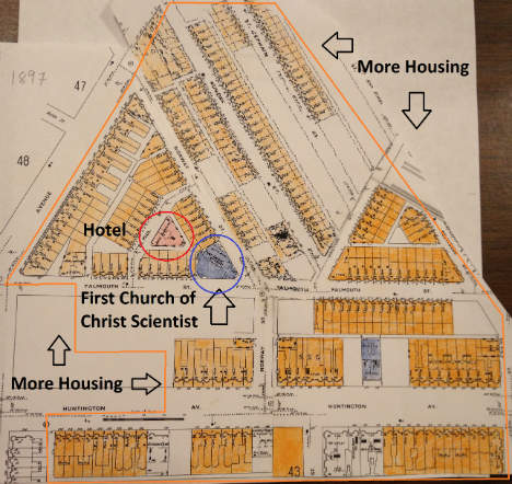
Only ten years later and the site changed dramatically, according to the 1897 Sanborn Map. The amount of buildings erect in this time span is stunning. This was probably made possible due to the railroad system that the US had at the moment. Transportation was faster and more efficient by this year, which allowed cities to be built out of nothing in a very few time span. In Crabgrass Frontier , Kenneth Jackson explains, “ Between 1815 and 1875…the introduction of the steam ferry, the omnibus, the commuter railroad, the horse car, the elevated railroad, and the cable car gave additional impetus to an exodus that would turn cities ‘inside out’ and inaugurate a new pattern of suburban affluence”(20). Most of the new buildings that were introduced were apartments. This shows that Boston’s population was increasing at a very fast pace and people had to start to move to the suburbs of Boston. In this case, the new parts of the Back Bay were the ones that were going to be heavily populated. The triangular shaped plot of land that used to be half filled with apartments in 1887 is now densely packed and all but two buildings are apartments. Falmouth Street and Huntington Street now seem to be densely populated by apartments (as you can see on the map, orange buildings are apartments, red buildings are commercial, and blue buildings are institutions). In 1887 Huntington Street and Falmouth Street are now have many buildings along them (mostly housing) and they now provide more traffic. This site is starting to look less like a suburb of Boston, and more like part of the city. My hypothesis for the almost empty lot in the southern part of the map is that it is on the western side of the map, while downtown Boston is to the east of this site. The closer parts of the site to Boston will be built first because they are more accessible. The density of buildings has certainly increased. At the rate that this site is growing, I expect that these empty spaces will be filled, and if I follow the trend then my guess would be they will be filled with apartments.
The land use is still mostly taken up by housing, although there have been different types of buildings introduced. The most diverse part of the site is the triangle shaped lot. The east corner of the plot has now been turned into The First Church of Christ Scientist church. By looking at the map, it seems that the corner of the triangle was not intended to be a church. My hypothesis is based on the fact that the church seems to be squeezed into that little corner in between all the apartments. Looking at all the apartments in this plot of land, I would have never guessed that this small corner would turn out to be a church. But the fact that the church turned up there unexpectedly, suggests that the population of this religion was increasing in the area at this time, and that is was somewhat powerful. The location of the church is very convenient. The corner of the triangle allows for more visibility and accessibility. Hotel was built in the central part of the lot of land. This suggests that the site is increasing its commercial borders and is now erecting more buildings to make profit or produce jobs. The location of this Hotel though seems a bit strange to me. The ideal place to put a commercial building would be an area where the building is very visible and very accessible, like the corner of a block or at least along a street. This Hotel is not located on any major street and is completely surrounded by apartments. My only assumption is that the Hotel might have been cheaper to build on that part of the site.
Another church was built on what appears to be a neighborhood. The street that this church was built on seems to be a small neighborhood street. The church is surrounded empty lots though. A reason for this might be that the church plans to expand, or nobody decided to build next to the church fearing the church would expand. This church seems to be much smaller than the First Church of Christ Scientist.
By this time the West Chester Park street name has been changed to Massachusetts Avenue. Caledonia Street, which is the street that borders the triangle shaped lot of land on the north side, has been changed to Norway Street. Cromwell Street, which is a street on the northern part of the site, has been changed to St German Street. The changing of the names might have been influenced by people with money.
Overall, there were mayor changes in only ten years probably due to new transportation methods like the trolley, which represents, “ progress and technological achievement” according to Jackson in Crabgrass Frontier (111). The city of Boston is expanding and there are suburbs being created. There are more and more diverse buildings being built in the land which makes the land seem more normal, instead of just all apartments or all institutional buildings.
1937: Church Takes Over
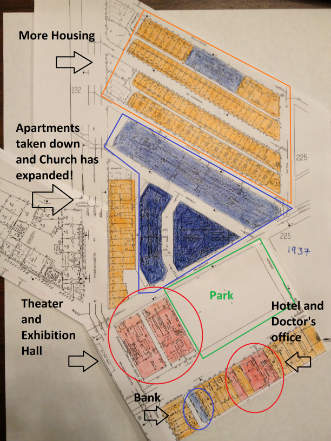
During the forty years since 1897, there have been more major changes to the site. The most obvious and important change is the expansion of The First Church of Christ Scientist. The church used to take up only the small corner of land, and by 1937 has taken up most of the triangle shaped lot, and the whole lot of land that is just across the street to the north of it. The size of the church has increased dramatically; it is quite impressive. Not only were the apartments demolished, but also the hotel that was located in the between all the apartments. The demolition expand the borders of the church, which is now a very powerful and very grandiose church. The plot of land that is to the north of the central building of the church has now turned into the Christian Science Publishing Society (i.e. a newspaper publisher headquarters). The building located to the west of the central Church building was turned into the Christian Science Administration Building. These buildings belong to the church which suggests that the church has gained a lot of money over the years. This obviously means that this religion has also increased dramatically in this area over the years. The fact that the church was able to tear down apartments and a hotel to make room for more buildings is very extraordinary. The apartments that run along Mass Ave. still remain at this time. If I had not known what the church looks like today, I would have never guessed that the church was going to expand so much. There have been additional apartments on the new neighborhoods to the north of the Christian Science Publishing Society building. The New England telephone and telegraph company has been built in this neighborhood. A reason for why this company is so far from the others on the site is that there might be another commercial/industrial site to the north of that. There are four huge rows of housing. It appears that the housing land has shifted from the central part (triangle shaped lot) to the northern part of the site.
Another big change is that some of the apartments that were located on the southern part of the site have also been torn down in order to make a park. This park takes up most of the space of the lot but not all of it. Kenneth Jackson explains how, “The suburban dream demanded an enlargement of open areas”. He goes on to explain how rural commentaries, suburban cottages, and in our case parks were “advocated for the benefit of ‘aesthetic and moral nature’ as well as physical health” (55). The creation of the park was just one step closer to becoming a part of Boston. The left third of the lot is for commercial use. Here you will find the Uptown Theater, and the Exhibition hall. To the south of this lot, you will find that some of the apartments have also been torn down to make way for other buildings. In this southern lot, there is a line of apartments, but with some different buildings too. There is bank, a hotel, and a doctor’s office scattered in these buildings. The buildings look just like the apartment buildings from the map but they are not used for housing. This could be because most of the land is already taken and so the owners had to buy a building that was already built; the easiest types of buildings to take over would be apartments, I think.
Overall the ratio of the land usage has changed. Less land is used for housing in some places and more in some. The church has expanded to a huge complex that takes up almost two entire lots of land. A park and more commercial buildings have been added. The whole site is becoming less about housing and more industrial and commercial (more like a city).
1951: Minor Changes
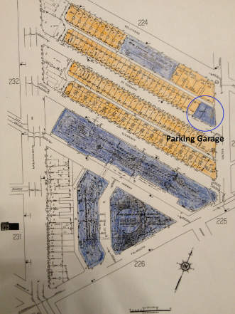
Although the site did not change much during the period of 1937-1951, some apartments in the northern part of the site were converted into a parking garage. This is another sign of the decreasing housing area and increasing institutional area trend. Not much else changed during this period. This could have been because there is no more room to expand and there is already a balance between housing, commercial, and institutional land.
2013
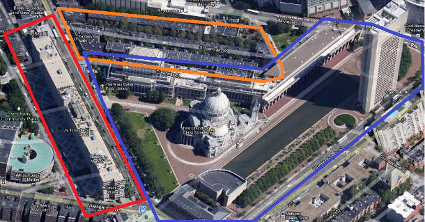
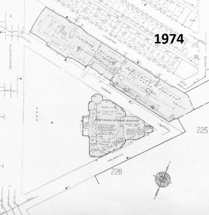
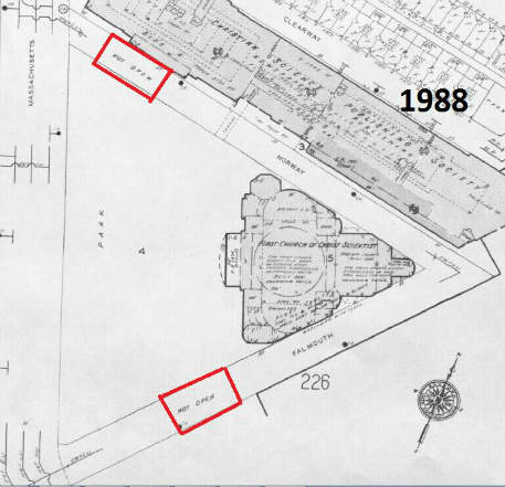
The site now has also gone through some changes, but once again, the trend of turning into part of Boston has continued. Housing was taken down to expand the Church even more. The church even took over the neighboring streets and closed them down. Other maps show that the circulation of these streets was stopped by the church sometime between 1974 and 1988. The church has “recently” built a reflecting pool and several other buildings next to it. This means that the church is still very strong and very powerful. This First Church of Christ Scientist is the “mother church so it is very important to this worldwide religion. The other housing and commercial areas have remained the same. There are still commercial areas in the west side of the site and there are still some housing areas in the northern part. Now, because the apartments are located between some very distinct and big buildings, the apartments are the ones that seem out of place. The Church now takes up a huge chunk of the center of the site.
The trend that this site shows is similar to the sites around it. As Boston grew, it took over the neighboring areas, like the Back Bay. This whole area contributes to the expansion of Boston and is defiantly not a suburb of Boston anymore.