Sometimes when walking through a city you may see some inconsistencies in the buildings, like the age or the location, but you do not realize them and if you do, may not connect them to the reason. It is always helpful and interesting, in my opinion, to know why things are the way they are. In my case, I did not even realize that some buildings look a lot older than the buildings beside them, or that some buildings are huge compared to others in that same area. I never gave thought to why this is the way it is because of my lack of attention. Lack of attention is not the only thing you need to realize why buildings are the way they are; you may also need to know a little bit of history of that place. The very first time I visited my site, I walked around and the only thing that caught my eye was the church. The church is huge and grandiose; it is hard not to notice it. I thought it was a great building but other than that, I did not think much of that site. I chose to study this site because I had never seen such and interesting church, and I wanted to find out how that came to be. After studying the maps of different years of this site, I realized how important it is have a little bit of knowledge on the history or the background of a site. Studying the site through time gives you a perspective on when the buildings were built, or who owned the buildings, and if there were other things on the site that are no longer there that affected the shape of the site now. There are many interesting things that are discovered when looking at the maps, but it is even more interesting finding traces of the past in the site now. After studying the maps, I went back to the site and felt almost like it was a new site. It is great how many things you notice now that were not able to before.
By looking at this site changing through time, you can already tell where some traces of the past can be found. The site had some changes throughout time, but the most important changes happened because of the First Church of Christ Scientist, in the middle of the site. The church started off as a small building in the corner of a lot. As I looked at maps from years after that, I noticed that the church became powerful and expanded by taking down buildings and streets. This already raises some questions about buildings that still stand or if there are traces of the buildings that have been taken down. I also noticed some older-looking buildings in the site now that still stand in old maps.
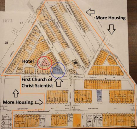
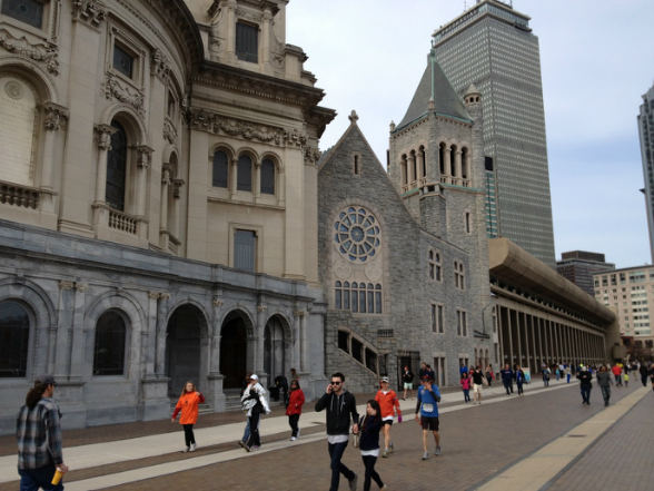
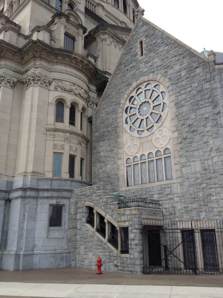
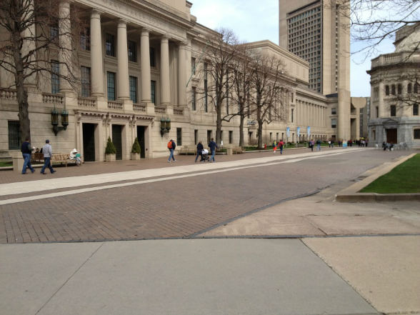
As I looked through the maps, the first question I raised was about the church. The church was built before 1897. The location of the church, I thought, was interesting because it seemed like it was squeezed in between other buildings. The lot of land where it is located was full of housing; there were mostly apartments and one hotel. The church was in the corner of the lot surrounded by apartments, a hotel, and two streets. Because of the huge amount of apartments in the area, it seemed like the church would eventually be taken over by housing. The 1937 map shows that what happened was exactly the opposite. As you can see, the church completely took over half of the apartments in the lot, and even took over the hotel. The hotel and apartments were taken down to expand the church. The church even has a building across the street by this time. This is pretty impressive and shows the power of the church. It made me wonder what the church is capable of and what it would do next. This is where my first question came up. I wondered if the original building of the church was also taken down to build a completely new church, or if it still stood, and the expansion was just an addition to the original. I answered the question when I revisited my site. As you can see from the picture, the original building still stands. It is still in the corner of the lot but the lot has changed. From this picture you can clearly see the difference in the original building and the “new” building. The styles and also the materials of these buildings are very different. It is obvious that the small building is much older than the rest of the structure. I wonder what people think of this because I doubt that many know the history of the church and the history of the expansion. In this picture you can see the new church on the left, the original in the center, and also another building, also owned by the church, on the right. This building was part of the expansion and is the Christian Science Publishing Society. You can tell by the style of the building that it is not a church, but you can tell that is it a part of the church. The structure of the building is not as detailed and impressive as the church, but the material seems to be similar. This building also seems to be built after the expansion of the main church. This building does not look as old as the other two structures in the picture, but you can still tell it is old when you compare it to the Prudential Center (the skyscraper in the back). There are many people walking around this church, but they do not seem to pay attention to the traces of the past. It may be because they are very used to this place, or maybe because they are just not paying enough attention, like me when I first visited this site. This picture, I think, captures most of the history of the church. The traces of the past are clearly visible, and the history of this site can be seen, from the original church from the 1890’s to the expansion in the early 1900’s to the modern skyscrapers that stand today.
The church took down many buildings over a large area so I tried looking for traces of all the buildings that were taken down. All that stands there now is the new church and the garden. The picture below shows part of the front of the garden. The ground is uneven but I doubt that that has anything to do with the buildings that once stood there. The uneven ground is probably caused by the trees. There was no other trace that I could find of the buildings that once stood there. There is absolutely no trace of them anymore. The only things that still stand from those times are the streets.
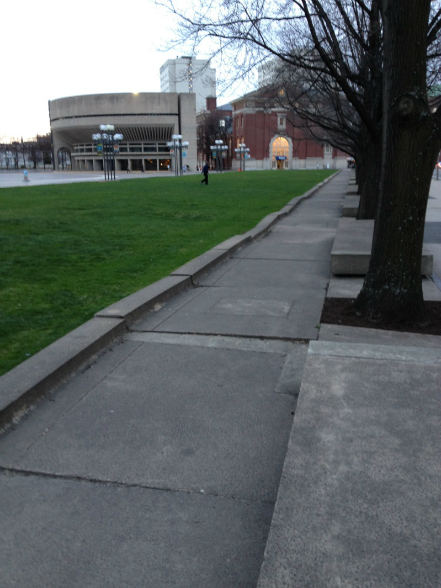
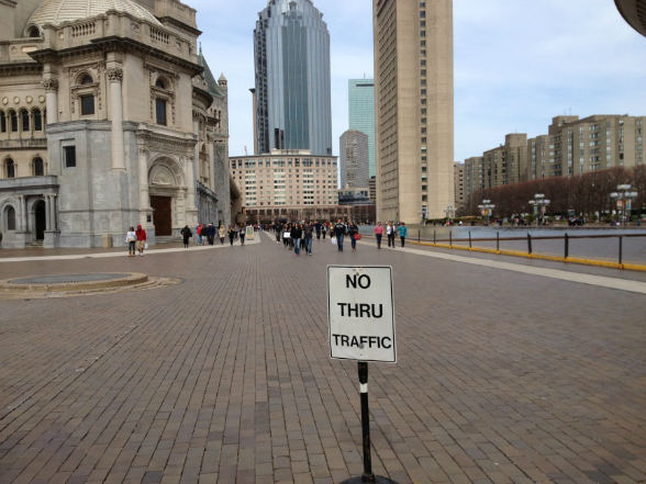
The church seemed very powerful in this site, so I looked at more maps to see if the church influenced other characteristics. By 1974 the church had taken over the entire lot of land it was based on and even took up land across the two streets that bordered that lot of land. One thing I noticed when comparing the 1974 and the 1988 map was that the two streets bordering the church are labeled as “Not Open”. This means that at some point between 1974 and 1988, the church also took over the streets, and now they are not open for vehicles. The streets are only used for pedestrians. The church taking over the streets and closing the vehicular circulation is quite impressive but not surprising, considering the church took over practically everything surrounding the original church. As you can see in the pictures below, the streets still stands, but there is a sign that reads “NO THRU TRAFFIC” that blocks all vehicles, and now many pedestrians walk through this street. You can clearly see the outline of the streets on the pictures, and you can also see that beyond these outlines are buildings owned by the church. The picture on the left depicts the street that borders the church on the north side. The Christian Science Publishing Society is located to the left of the street. This is the same building from the previous picture but from another angle. From this view the Christian Science Publishing Society looks much more important and defiantly stands out more. The style of the building is still different from that of the church and I would say that it looks more like a very old school, or a government building. The church and the garden in front of the church are located to the right of the street; this is where the hotel and the apartments that were taken down used to be. The tall building on the back is also owned by the church, but it is a bit farther away than what is seems in this picture. The picture on the right depicts the street that borders the church from the south side. You can see the church and the garden is to the left of the street. To the right of the street, though, are two more buildings owned by the church (only one is shown in the picture) and a big reflecting pool. The big reflecting pool and the buildings are other things that show the power and importance of the church. Going to the site now, without knowing anything about it, I think no one would think that those were streets surrounded by apartments and a hotel. I doubt that people that go through this site now think that the streets they walk on were actual streets. When I first walked through here, I thought that what I was walking on were just some sort of fancy sidewalk structures that go along the church and to the rest of its buildings. After studying the maps I knew that the streets left a trace of what used to be a neighborhood full of apartments and housing.
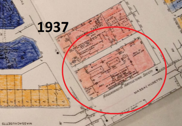
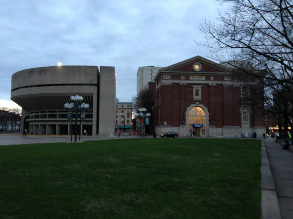
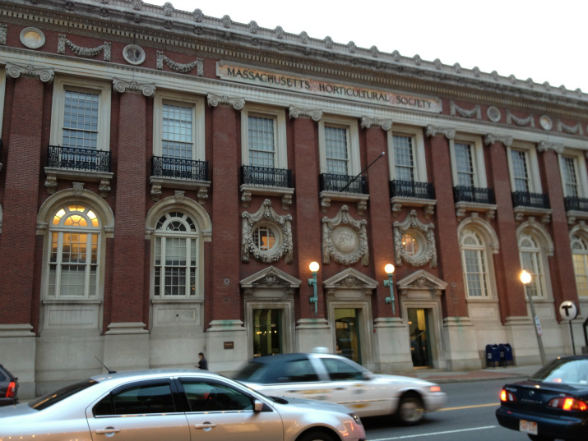
The church seems to have taken down and remodeled everything, except for one thing, which seems to be the only thing out of place in this lot. The Massachusetts Horticultural Society building is the only building that is not owned by the church, and is standing since before 1937. The Massachusetts Horticultural Society building first shows up in the 1937 map but at this time, the church does not own anything on this lot of land. It seems like the church did not want the building or could not get it. This building looks a lot different than the church buildings and it stand out because, it looks older than the building beside it, and because it is red, when all the other buildings are gray. This building is made of brick unlike the church buildings. This building is definitely not as old as the original church, but it is still a trace of the past because it has survived many years.
1951: Minor Changes
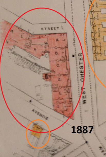
One other connection that I was able to make from the maps is the building that stands in front of the church across Massachusetts Avenue. This building shows up in the earliest map I have which is an 1887 map. In 1887 the building was a warehouse and it ran all along the block. The building was huge compared to the rest of the buildings at the time. Today, 126 years later, the building is still one huge building. It was not taken down and turned into many other buildings. When comparing the maps form now and 1887, this is the only building that still stands.
There are few traces from the past because the church took down many things. It was very interesting to find that the original church still stands and has the older look to it. It contrasts with the buildings surrounding it, and highlights the traces that the church made over the years. It was very interesting to see that the church own everything on the lot except for one building that certainly stands out. It might be interesting to find out the reason for this.