Boston, Massachusetts has gone through many changes since its establishment in the 1630s, with particular regard to the land. Referencing an early map of Boston in the 18th century, the present-day shoreline along the Charles River did not exist. What was once just a body of water is now covered in land as a result of major landfills in the 18th century. The site I have chosen was built upon the major landfills in the 1850s. It is bordered by Massachusetts Avenue, Newbury Street, Public Alley 429 and 428, and Gloucester Street.
The site has morphed into a popular residential and shopping district from its early times. In observing Sandborn maps from 1887 to the present day, the most significant change is of land usage. The change was mainly brought about by the switch of horses to automobiles, the development of the suburbs, the Great Depression in the 1930s, and population growth. Due to these experiences, today Commonwealth Avenue is a residential street, the Public Alleys are used for parking, and Newbury Street is used for commercial businesses.
Original observations from the Sandborn Map of 1887 (to compare changes):
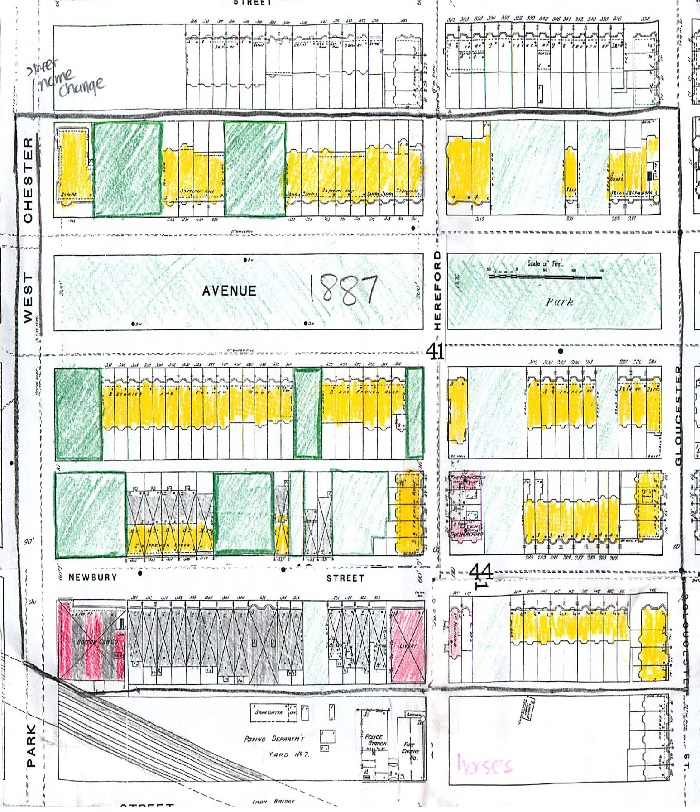
1887 Map
Commonwealth Avenue
By 1887, the Back Bay area of Boston was completely filled in by land. The Sandborn Map of 1887 shows a majority of single-family homes on the site, as indicated by the yellow, with a few spots still vacant. These were later to be filled in by more houses. Along Commonwealth Avenue, there is a strip of land labeled “Park”. This was built in originally for aesthetic purposes. In Crabgrass Frontier, Kenneth Jackson mentions, “First, rural cemeteries, later parks… were advocated for the benefit of ‘aesthetic and moral nature’ as well as physical health,” (Jackson 55). In the mid-1850s, the suburbs were especially appeasing to buyers due to open areas that could be used for gardens or play areas.
Since Commonwealth Avenue was located in the city of Boston and had a park running down the middle, as indicated by the green, residents could get part of the suburban view while taking advantage on what the city of Boston had to offer. As a result, this became an area of prime real estate that attracted many wealthy people. The name of ‘Commonwealth’ Avenue could symbolize that all residents that lived there were upper-class residents.
The park on Commonwealth Avenue not only offered a great view and an escape from the pollution that to city of Boston could offer, but also had large row houses that had three floors and a French roof. Row houses proved a safe haven from the dangers that the suburbs could offer. Jackson writes that the Puritans, “…regarded the wilderness as the dark and terrifying home of Satan’s minions…As a result this hostile view of nature and because public transit was either lacking entirely or uncomfortable and slow, wealthy Americans preferred attached or row houses,” (Jackson 55). Commonwealth Avenue had to offer what Jackson notes here plus a view of the park making the avenue very attractive to those of the upper class. In addition to this, these large houses on Commonwealth Avenue were very spacious for the single family.
The lack of stables on Commonwealth Avenue is described here by Jackson: “A family wealthy enough to have a horse and carriage would have stored such possessions either in a public livery stable or in a private structure at the rear of the property,” (Jackson 251).
Overall, Commonwealth Avenue began as a wealthy street that attracted many upper class residents in the late 1800s.
Newbury Street
The Sandborn Map of 1887 of Newbury Street varies drastically from Commonwealth Avenue. Between West Chester Park (now Massachusetts Avenue) and Hereford Street, many single-dwelling homes have a stable on the first floor and living quarters upstairs indicated by the yellow and grey. On the corner of West Chester Park and Newbury Street is a Boston Cab Company with a stable included, as indicated by the grey and red stripes. Since the date is 1887, this shows that the company offered transportation for small parties, probably around four or five. It may even have a connection to the popular ‘horse car’ that Jackson mentions in Crabgrass Frontier. At the other corner of Newbury Street and Hereford Street, there is a livery that stores horses. This livery was probably used by some Commonwealth Avenue residents as described above.
Newbury Street was very transportation-related. As a result, this location was attractive to home-buyers. In relation to the horse car, Jackson writes, “…the very availability of quick efficient mass transportation enhances property attractiveness…” (Jackson 40). Although there is no real indication that there was a horse rail nearby, this can still be applied to the many horse stables found on Newbury Street between Westchester Park and Hereford Street. People liked the idea living near transportation.
However, the residents that lived on this block of Newbury Street had to face a trade-off. In the back yard of the north facing side of Newbury Street laid the Boston and Albany Railroad. It is important to note that the B&A railroad was located on the site long before the site was developed. The railroad probably provided long distance transportation between Massachusetts and New York as the name suggest. Like many of the steam-powered trains at that time, the B&A Railroad was noisy. In addition to the “…whistles and clattering wheels…” (Jackson 38), the steam engines on the locomotive proved to be dangerous. Jackson writes of an engine that exploded in New York that left twenty one people dead (Jackson 38). Not only were steam railroads noisy and sometimes dangerous, but they caused pollution. “Smokestacks belched soot into the air of every city, and nearby sections soon turned to slums…no one with options wanted to live in close proximity to important rail lines…” writes Jackson (Jackson 69).
This is very apparent in between Westchester Park and Hereford Street on Newbury Street. These residents lived in houses with their horses-an indication that shows they weren’t really wealthy. The houses on Newbury Street were of lesser value due to the B&A Railroad. So although these residents lived in an accessible part of Boston, they had to deal with noise and pollution. This concept is boldly illustrated in the Sandborn map of 1887 where Newbury Street is gray between West Chester Park and Hereford Street, which shows transportation, as opposed to the yellow on Commonwealth Avenue. In addition, Newbury Street between Gloucester Street and Hereford Street resembles Commonwealth Avenue since it is quite a distance from the B & A Railroad.
Overall, Newbury Street was occupied by houses and stables which attracted the middle and lower class population.
Alleys
There is not much to say about the alleys. As shown on the Sanborn Map of 1887, the alleys located on the site’s boundaries and Commonwealth Avenue and Newbury Street, the alleys are vacant. Jackson gives some indication of what they might have been used for: “…small rear yards were apt to be covered with back-alley dwellings… Rear areas were usually less than typically rancid, disreputable, and overrun by rodents,” (Jackson 56).
Observations from the Sandborn map of 1897 (Population Growth):

1897 Map
Commonwealth Avenue
Ten years later on Commonwealth Avenue, one can begin to see the increase of population growth. What is particularly interesting is all vacant lots that were filled since 1887 were occupied by flats or hotels in 1897, indicated by the orange and red respectively. These buildings are much taller with six floors as opposed to the surrounding houses of four floors. In 1897, upper-class society was not interested in building houses anymore because of the appeal of the suburbs and improved transportation. Instead, these flats were built and offered at a lower price.
Also introduced
are corner stores seen on Commonwealth Avenue and Massachusetts Avenue.
These corner stores provided food and other merchandise that would meet
the residents’ need.
Newbury Street
Not much changed on Newbury Street over ten years. On the corner of
Massachusetts Avenue and Newbury Street, a large stable was built as
indicated by the grey. This shows that there is still a strong usage of
horses as transportation in the late 1800s.
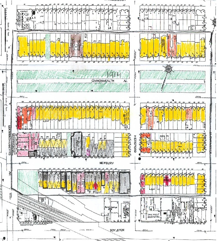
1914 Map
Newbury Street
Here introduces the influence of the invention of the automobile. In 1860, Etienne Lenoir developed a prototype of the automobile, according to Crabgrass Frontier. “By 1908,” Jackson writes, “twenty- four American companies where producing simply constructed automobiles at low prices…by 1913, there was one motor vehicle every eight people…” (Jackson 160). This is heavily due to the success of Henry Ford’s ‘Model T’ automobile- an automobile that dropped from $950 in 1910 to $290 in 1924. As a result, many people could afford cars.
On the corner of Massachusetts Avenue and Newbury Street, what was once the Chris S. Brown Company Livery in 1897 was now vacant. The livery on Newbury Street and Hereford Street in 1897 changed to a garage in 1914. Since there was an increase in public transportation of street cars and horse cars, and now the newly invented car, no longer did people need to rent horses as these examples show.
In the Sandborn map of 1914, the black borders around the gray-shaded sections indicate the presence of garages. These houses that were once houses with stables below, turned into houses with garages below, or completely garages.
The phenomenon of the appearance of these garages is due to both the introduction of the car to the United States and the appeal of the suburbs. In Crabgrass Frontier, Table 9-1 shows that in the United States, there were 8,000 Automobiles in 1905 which increased to 2,333,426 in 1915 (Jackson 162). Because of the increase of cars and no vacancies in Boston by 1914, garages were the apparent solution. These garages probably provided a shelter to store cars to the upstairs owners.
Observations from the Sandborn of 1937 (The Great Depression):
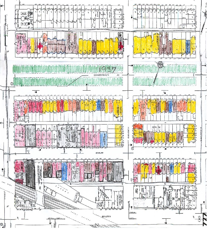
1937 Map
Commonwealth Avenue
The Great Depression in the 1930s caused great changes on Commonwealth Avenue. According to Jackson, “Between 1928 and 1933…the expenditures on home repairs fell by 90 percent,” (Jackson 193). This describes the ‘fall’ of Commonwealth Avenue. No longer could the upper-class afford to stay in their large brownstone homes. It was much cheaper to sell their homes and move to the suburbs where houses were affordable. The house values dropped and those who still had substantial money found the opportunity to buy these vacant properties. To profit from them, these owners would rent them out to the middle or lower class, or use them as stores. In the Sandborn map of 1937 in comparison to the 1914 map, there is more of a variation in the land usage. In 1914, single-dwelling family homes occupied most of Commonwealth Avenue between Massachusetts Avenue and Gloucester Street. By 1937, most single-dwelling homes turned to apartments, flats, stores, doctor offices, or institutions indicated by brown, orange, red, red crosses, and blue respectively.
Newbury Street
In the Sandborn map of 1937 compared to 1914, there was a great increase in garages between Massachusetts Avenue and Hereford Street. According to Jackson, production of the automobile was not affected by the Great Depression. “In all but the three deepest depression years, motor-vehicle registrations continued to rise, and the 1940 total exceeded that of 1929 by 4.5 million,” (Jackson 252). More garages were established since 1914 to accompany the increase in cars. In some cases since not much was done to keep up the conditions of buildings, owners found it cheaper to turn those buildings into garages and profit from the pay. Influenced also by the increase of automobiles was the presence of automobile shops as indicated by the red bordered by black on the 1937 map.
The few stables that were left in 1914 between Massachusetts Avenue and Herefords Street on Newbury Street were gone by 1937. During this time, cars had become more popular and people found no need for the stables. The vacancies mostly became stores as upstairs owners probably found it more economical, like the Commonwealth Avenue residents, to sell their homes and move to the suburbs. '
On the other side of Hereford Street on Newbury Street faced similar changes like Commonwealth Avenue. However, there are no stores on Commonwealth Avenue as there are on Newbury Street between Hereford Street and Gloucester Street. Here, the influence of the other side of Newbury Street can be seen here.
Observations from the Sandborn of 1974 (Garages and more Automobile):
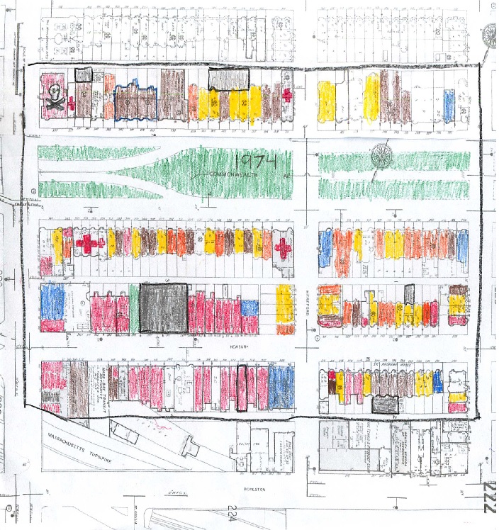
1974 Map
Public Alleys
The Public Alleys changed since the Great Depression era. With the increase of automobiles noted by Jackson from 22,567,827, to 106,713,000 from 1935 to 1974, garages were still needed. As a result, the alleys that were useless in the late 1800s suddenly became convenient for garages. On the Sandborn map of 1974, grey sections bordered by black along the alleys indicate garages.
Newbury Street
On both the Sandborn map of 1937 and 1974, lie the subway entrance on the corner if Massachusetts Avenue and Newbury Street. Here illustrates Jackson’s observation on resident areas near public transportation: “…the very availability of quick efficient mass transportation enhances property attractiveness…” (Jackson 40).This meant that if residencts in the area wanted to go into downtown Boston or go to work, they could easily do so.
Observations from the Sandborn of Present Day:
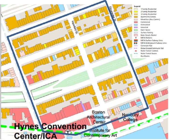
Present Day Map
Commonwealth Avenue
There are very little changes from 1974 to present day. Most buildings along Commonwealth Avenue are now apartments if they were single-family dwellings on the 1974 map. Population growth in the area now is due to the Hynes Convention subway stop on Newbury Street and Massachusetts Avenue and the “1” bus that runs cross city along Massachusetts Avenue. These two modes of transportation provide convenience to the residents in the Back Bay area.
Newbury Street
Newbury Street hasn’t changed much either. The only difference from 1974 to present day is the absence of parking garages. As public transportation became more convenient and efficient, it would be of inconvenience to travel by car.
Conclusion:
Commonwealth Avenue was created as a residential site for the wealthy. It offered large homes for single-dwelling families with a nice view of the Commonwealth Avenue mall between the two blocks. Major changes occurred due to the Great Depression in the 1930s. Owners sold their homes and moved to the suburbs, a cheaper alternative. The large homes became apartments, affordable to the middle-class in the 1930s and useful to the population growth- which still exist today.
Affected by its close proximity to the Boston and Albany Railroad, Newbury Street became a street of single-dwelling homes and stables for the middle class. Although the homes were comparable in size to Commonwealth Avenue, residents had to deal with noise and unpleasant pollution. Newbury Street was mostly changed by the introduction of the automobile in the early 1900s. As cars became more affordable, transportation by horse became unpopular and the stables below houses were useless. These buildings either became stores or garages by the 1940s. Then by the 21st century garages became scarce as public transportation became more efficient. Today, Newbury Street is filled with many commercial businesses.
The Public Alleys were affected the most by the automobile revolution. What started out as an unkempt place turned into parking spaces for those residents and employers.
All of these experiences, as illustrated by the Sandborn maps, changed the site into what it is today. Commonwealth Avenue is a residential street, the Public Alley’s are alleys used for parking, and Newbury Street is used for commercial businesses.
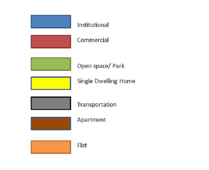
Key:
Bibliography:
Jackson, Kenneth. Crabgrass Frontier- The Suburbanization of the United States. Oxford: Oxford University Press, 1985. Print.
Map 1974: Map from Digital Sanborn Maps (The Sanborn Map Company, Sanborn Library 1867-1970), showing Back Bay circa 1950,
Map 1937, Map 1914, Map 1897, Map 1887: Map from Digital Sanborn Maps (The Sanborn Map Company, Sanborn Library 1867-1970), showing Back Bay circa 1900, http://sanborn.umi.com/cgi-bin/auth.cgi?command=AccessOK&CCSI=254n
Present day map: Map from Boston Redevelopment Authority , showing Back Bay circa 200, http://www.bostonredevelopmentauthority.org/pdf/maps/backbay.pdf