This week in lecture, we investigated the evolution of the section of the class site bounded by Osborn, Main and Vassar Streets over time. Comparing old maps allowed us to determine the change in land use and property ownership over time.
Our site was predominantly empty in the 1873 map, with only a small cluster of buildings in the northwest corner. Since the railroad runs across Vassar Street, it was determined that the empty land was probably owned by the railroad company. The cluster of buildings in the northwest was owned by Allen & Endicott Bldg. Co. and was composed mainly of a foundry and several machine shops and factories, with several warehouses on the outskirts.
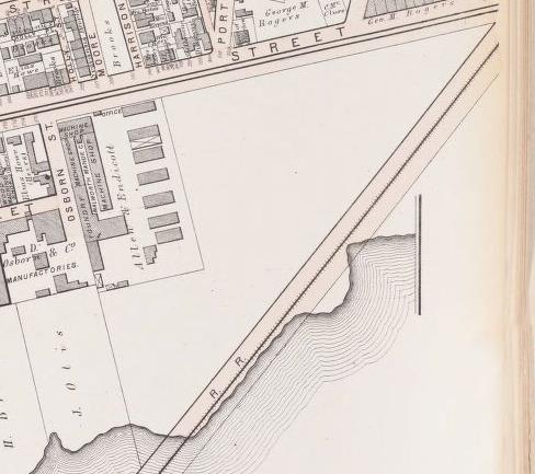 Figure 1: Map of 1873 [1]
In 1903 we see that the land use in our site is mainly industrial. Several buildings within the area owned by Allen & Endicott have been torn down in order to build a lumber company. The previously empty land is now littered with many small factories, the largest of which are a piano factory and a shoe factory. Coincidentally, these are the only two new buildings made of brick. The other buildings that have been built since 1873 are primarily wooden-framed. Aside from Allen & Endicott, the only other large property owner that is present during this time is the Ivens & Pond Piano Co.
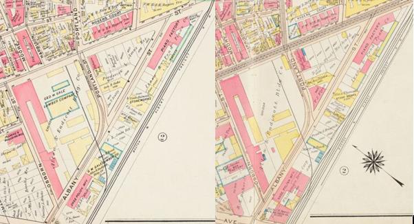 Figure 2: Side by side maps of 1903 (left) and 1916 (right) [2]
We don’t see much change along the railroad from 1903 to 1916, aside from the shoe and piano factories expanding by one or two brick buildings. The major change we see is that the lumber company and several nearby warehouses have been torn down, leaving that area empty. All of the buildings constructed since 1903 (mainly within the property owned by Ralph, Fred & Burkard) have been brick.
In the 1930’s, automobiles have become a predominant mode of travel due to the introduction of Ford’s assembly line. We see a response to this in our site, since practically all of the new buildings constructed since 1916 have been garages. The property owned by Ralph, Fred & Burkard has been replaced with an enormous building titled Main St. Garage Inc. The property previously owned by Allen & Endicott Bldg. Co. has been split up amongst several different property owners, the largest of which is the Osborne Realty Corp.
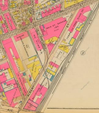 Figure 3: Map of 1930 [2]
By 1970, we see a large shift from the diverse land use and property ownership of the 1930’s. The land is now primarily owned by either the Polaroid Corp. or MIT. MIT has replaced many of the buildings along the railroad with garages and laboratories. The Polaroid Corp. has taken over the land previously owned by Allen & Endicott as well as the land owned by Main St. Garage Inc. The Latex & Chemical Co. was built on a plot of empty land (save for a few garages). This is likely a response to the nearby research laboratories built by MIT.
References:
1. Hopkins, Griffith Morgan. Atlas of the City of Cambridge, Middlesex Co., Massachusetts. Philadelphia: G. M. Hopkins & Co., 1873.
2. G. W. Bromley & Co. Atlas of the City of Cambridge, Massachusetts: From actual surveys and official plans. Philadelphia: G. W. Bromley & Co., (1903, 1916, 1930).