The site I have chosen to investigate throughout the semester is a district of Boston known as the Bulfinch Triangle. The Triangle is a popular location for small stores and restaurants. Furthermore, upon visiting this site, I noticed some very clear traces of its evolution over time. A break is defined as a sudden change in the direction and design of the city street pattern [1]. In the case of the Bulfinch Triangle, there are some very peculiar breaks in the city structure around the site, giving it its unique shape. These breaks pose some interesting questions about how this area was first developed. It is for these reasons that I have chosen to study the Bulfinch Triangle over the course of the semester.
The Bulfinch Triangle is bounded by Merrimac Street, Causeway Street, North Washington Street and Market Street, shown below in Figure 1. Additionally, there are several key buildings that lie just outside the boundaries of my site, such as the TD Garden and several federal buildings. While I intend to limit my research to the area within my site boundaries, I will no doubt have to study how the emergence of these important structures has affected the Triangle’s transformation into a major center of transportation.
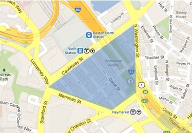 Figure 1: Map of Boston with selected site highlighted in blue. (Image from Google Maps)
When first selecting this site, my primary concern was choosing a location that shows a significant amount of contrast between colonial Boston and newer parts of the city. While looking the map of Boston from 1722 shown in Figure 2, my attention was immediately drawn to a drained body of water labeled Mill Pond, which was separated from the Charles River by a dam. Upon inspection of a current day map, it is clear that this land has since then been filled in. This plot of land later evolved into what is now known as the Bulfinch Triangle. This key piece of history provides a possible explanation for the odd shape of the site. During my future visits to the site throughout the semester, I will search for evidence that supports this hypothesis.
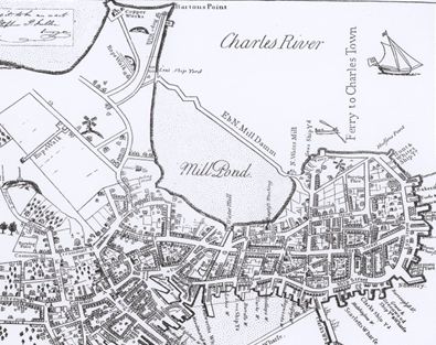 Figure 2: Section of a map of Boston in 1722 showing Mill Pond [2]
The Triangle has become a popular spot for small restaurants and shops, suggesting that the site has seen an increase in pedestrian traffic. This hypothesis is strengthened by evidence of buildings that have been torn down to make room for parking space. This may be partly due to the TD Garden being in such close proximity to the Triangle. However, an even more important factor may be the ease of access provided by the North Station, which lies directly on the northern border of the site. The buildings and structures within the site show clear evidence of alterations that may have occurred as a response to an increasing influx of pedestrians. Perhaps one of the most striking examples of change is the Rose Kennedy Greenway, which cuts directly through the Triangle. This marks the location where the Central Artery used to run through. The tearing down of the Central Artery and the installation of the Greenway is a recent change that could have a major impact on the future growth of the site.
The Bulfinch Triangle has undergone a significant transformation over the course of its existence. The increase in traffic to the sight has clearly had a significant impact in turning the site into a major center of transportation. Additionally, the Triangle has seen a wide variety of land usage, from small stores, restaurants and offices, to federal and recreational. These have all had an impact on the growth and evolution of the Triangle over time. All of these changes leave traces of their existence behind, some visible and some more subtle. It is my goal over the course of the semester to study these traces and document the effect they have had on the evolution of this historic site.
References:
[1] G. Clay, Close-Up: How to Read the American City, pp. 11-16 and 38-65 (Chicago, 1980).
[2] J. Bonner, The Town of Boston in New England, (Boston, 1722)