Feb. 9, 2013
I am very excited about this class. I have always found the evolution of cities to be interesting to observe, and am looking forward to learn techniques to do so more thoroughly.
I was thinking about the discussion on boundary points that we had in the first lecture, and realized that even the small town that I grew up in (Snoqualmie, WA) has distinct boundary features despite its low population and small size. Almost all residential areas are on one side of the railroad tracks that go through downtown, while all retail establishments are on the opposite side of the tracks. There are, however, some town buildings such as the town hall and post office on the side that is residential. Perhaps this indicates that the retail side of the town was built later, and formerly the entire town was on the residential side of the railroad tracks.
I am considering doing my observations on the West Fens. It is an area that is bounded by the Back Bay Fens on three sides, and a retail street on the final edge. I’m curious how this isolation affected the development of the community.
Feb. 16, 2013
I have selected my region in the West Fens:
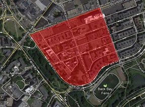
There are a number of features in this selection that I think will give it great diversity and provide some interesting facts about how the area historically developed. This small area features a good balance of retail establishments as well as domestic living space. There is also a small park within the region. It is of course also half bordered by the Back Bay Fens, so there is quite a bit of natural land that has impacted the growth of this area. There are also two churches within this region, which I imagine could shape the area substantially as churches tend to be treated very differently by society than other buildings.
I haven’t yet walked around the entire area, but last week I was walking through it and noticed a building that has an out of place lawn and structurally appears to have perhaps once been some sort of town building as we discussed in class.
Feb. 23, 2013
After the class meeting where we shared our selected locations, I became interested in the old maps and wanted to look further into exactly how my site fit into the historical maps. I ended up overlaying present-day maps to historical maps from 1800 and 1880, using geographical features as keys to get the alignment correct.
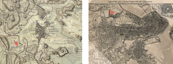 Figure 1 - 1880 (Waring)
These maps illustrate a few points. In 1880, the area appears to have been completely undeveloped, but actually did exist as land and was not in the areas that were filled. By 1880, the surrounding lands around my area of study had been filled, and there was a street system in place. The Back Bay Fens parkland also appears to have just started being established adjacent to my selection. It looks as though it was still not a highly developed area despite the streets existing. Perhaps the park was the main focus of work in the area, and houses began to be built shortly thereafter with the parkland acting as an attraction for building houses and apartments.
Mar. 1, 2013
With the conclusion of the natural processes assignment, focus will now shift more to the history of the land. I haven’t yet done any background research on the specific land use history of the area, but have started to think about how the formation of the surroundings contributed to the evolution of the West Fens.
Obviously, a significant factor that has shaped the land was the formation of the Back Bay Fens. Observations were made on Park Drive showing that the parkland created prime real estate for apartments due to the sunlight and the view of nature. I’m sure as I do background research into old property maps it will become much clearer exactly how the park affected the area over time.
An additional historic detail that may have had great impact is that although the West Fens was not filled land, it was isolated from a direct connection to Boston until the mid to late 19th century when the Back Bay was filled in. This likely affected the land use, especially related to industry. I will be looking for signs of these effects in future assignments.
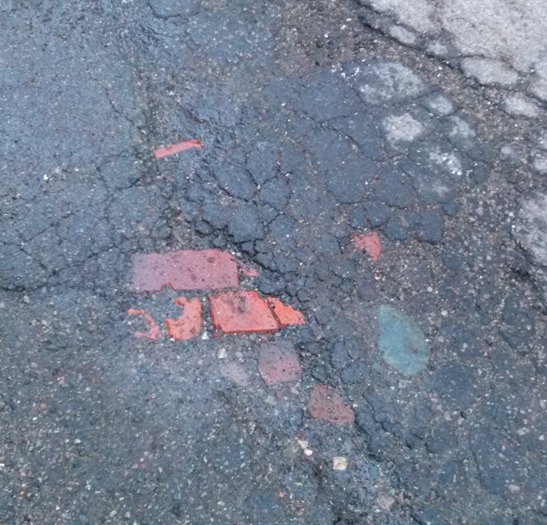
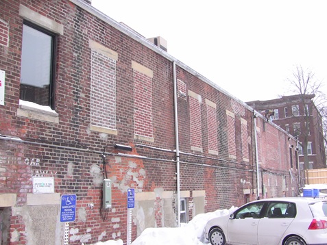
During one of my observation visits to the site, I noticed this brick below thin pavement in an alley. I’m not yet sure exactly what it means, but it is definitely a sign of layers of the past.
Mar. 9, 2013
As requested, this journal entry will consist of the information collected during Wednesday’s meeting when we broke into groups and analyzed the historic progression of a small part of the class site.
Our group’s selection was a triangular selection bounded by Osborn Street on the west, Main Street on the north, and the railroad on the southeast.
In the 1873 map, the most obvious feature is that almost none of the buildings that appear later are present. The only building is the one at the corner of Main and Osborn. The rest of the land does not have an owner labeled, so it is hard to say who owns it. It could possibly be owned by the railroad
Compared to 1873, the 1903 map shows that there was massive growth between those years. The most significant additions are the building of Albany Street and Portland Street, as well as building growth along the railroad. These buildings were most likely built as a result of the convenient presence of the railroad.
Another important feature of the 1903 map is that the Allan and Endscott Building Company grew in size significantly. This is quite likely due to the rapid growth in the area demanding the services of building companies.
There was very little change between 1903 and 1916. There was a new commercial building at Albany and Portland, but there are no large trends of note.
The main change between 1916 and 1930 is the development of parking garages. This makes sense, since between that time range was when typical citizens started to get cars, so they would need locations to park. Additionally, the Allan and Endscott Building Company was presumably sold to smaller companies as their previously large facility became a set of smaller businesses. I’m not sure exactly what this signifies, though.
Between the entire range of 1903 and 1930, there was little change in the buildings along the railroad. There were of course a few changes, but there wasn’t a continual growth. This surprised me, as I would think during that era, there would be great demand for warehouses and factories with railroad access.
Mar. 16, 2013
Since we have started collecting and analyzing maps for our sites, I will describe what I have found so far. The highest detail maps I have collected so far are Sanborn maps from 1937, 1974, 1988, and 1992. Unfortunately, between 1937 and 1992, very few changes are seen in the site. A church was built and several buildings were removed for additional parking. Otherwise, practically no changes of buildings or building use can be seen on these Sanborn maps.
Looking further back, I found a Sanborn map of 1895. Unfortunately, there is no data for this site in the map and the index says “This territory not built upon, will be added to Vol 2. As soon as improved”. Looking at old maps of less detail than Sanborn shows that in 1890, most of the roads were not yet created in the site (only boundary roads of Boylston Street and Park Drive). By 1895, most of the roads were constructed, but few if any buildings existed. By 1937, almost all of the present day buildings were created. This indicates a period of extremely rapid growth around 1900.
Fortunately, the Rotch Library has limited access collection maps that include a wide range of dates between 1900 and 1930 of primarily Bromley maps. I will be looking at those maps next week when the library is open and hopefully will see the changes that took place between that time period.
Mar. 23, 2013
Since my site was developed fairly recently, I've been working to find general trends that could explain the limited changes that I have been able to observe. I think the best explanation on which to base a paper thesis on is the changes caused by changes in the availability and use of ground transportation.
One possible instance of this are the changes on Boylston street after the 1930s. There were small retail stores on that street which turned into larger buildings (one was built into a shaws and another building was turned into an office high rise building). I imagine the demand for these types in of larger buildings was not present until the average person had a car. The timing makes sense given that the development occurred between the 30s and 70s which corresponds to when people started buying cars.
In the same time period there are also instances of buildings being removed to make more parking near living spaces. This could be because as people got cars, parking spaces would naturally be needed near homes.
I just received the crabgrass frontiers book so I will read about these concepts this week.
Apr. 6, 2013
Now that assignment 3 is complete, focus will move towards looking at signs of past changes in the present day site. After completing this last assignment, I’m sure next time I walk through my site I will look at it from an entirely different perspective and know of features to look for that may be traces of the past.
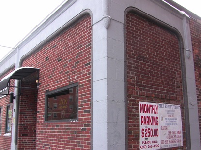
Even before I was aware of past changes to the site; however, I was still able to notice some fairly obvious traces of past activity. One instance of this is the building on the corner of Queensberry Street and Jersey Street. As can be seen in the following photograph, the building is obviously structured to have once been small store fronts, as illustrated in the Sanborn maps in assignment 3, which have since been filled in with brick and in this case consolidated into a single larger building.
The back of this building also shows signs of the past in that most of the windows have been filled in, as seen in the following photograph. This shows a change of purpose of the building. Windows were once desired for the buildings former purpose, but are no longer wanted.
Apr. 13, 2013
I really enjoyed the walk through the class site looking at old traces. Of particular interest to me was the corner of Portland Street and Main Street. It is amazing how distinctly different in era the four corners of that intersection are. I have walked through that intersection hundreds of times, but had never noticed the strong contrast of the buildings and land use until looking at the spot specifically from the perspective of historical land use. There is so much history sitting in plain sight on the streets we walk down every day. Hopefully after completing this assignment, I will be much more observant of such features!
I have not yet had a chance to visit my site to take more pictures of traces of the past, but will definitely do so during this weekend. I have, however, started looking at the maps of my site in search of features that have had changes in the past which I hope to be able to see in the present day. Naturally, many of these changes follow what was discussed in the previous paper, and it is likely that the story told by the changes I observe will be very similar to the story seen in the historical maps since the maps just represent the reality of the land use in the site. This means many of the traces will likely be the result of changes in transportation technology.
One of the specific features I will look for are changes in the structures that were historically small convenience corner stores. I already noticed some of these types of changes (as shown in my previous journal entry) on Jersey Street before even studying the historical land use. I hope to observe more of these retail changes on Kilmarnock Street, where the historical maps used in my third assignment show significant changes in the use and subdivision of the buildings.
Another location where there may be quite a few traces of the past is on Boylston Street. This street has had the most recent and significant changes of land use and changes in buildings of all the areas on my site, and many of the previous structures may have traces still visible today, depending on how extensively the previous structures were eliminated. Specifically the Shaw’s Market and the large retail building, both on Boylston Street, are examples of previous buildings being expanded into larger structures which may have left traces of the previous structures.
Apr. 20, 2013
Most of the work for 4.211 this previous week has been dedicated to working on assignment 4. I was able to find quite a few images representing traces and/or trends during a site visit last weekend. I will focus the majority of my analysis on three photographs.
The first of these is an image of Kilmarnock Street, where there were previously two buildings of small stores. One of these buildings was completely eliminated and a multi-story hotel was put in its place. The other building remains in place, but has been turned into a single restaurant rather than being a row of small community stores. This shows multiple trends of how property is being used in the city. In both cases, the small stores being removed is a representation of business moving towards larger malls and supermarkets. With the apartment going up (along with other apartments being built in the last few decades on the site), it shows that there is greater demand for living space than for retail space within the West Fens. The restaurant taking the place of the other stores is representative of the demand for food service increasing, with decreased demand for small community stores.
Another image I will focus on is that of a strip of small stores on Peterborough Street. This building was completely renovated in 2009, but its state of being a set of small retail locations remains as a trace of its initial construction. It now consists entirely of about 6 restaurants. Again, this is an illustration of food taking over shopping locations in a small community. This one is particularly important, because the change occurred so recently. It is possible to assume from this observation that these changes are still occurring to this day and will continue into the future, since this was only three years ago.
Finally, a view of Boylston Street shows the recent installation of Shaw’s as well as a high-rise building of offices and restaurants. This is again an example of drawing business away from small stores. The expansion in popularity of large malls and department stores is evident across the street, and such stores will continue to damage the profits of community stores even into the future.
Apr. 27, 2013
With the completion of all the assignments, it is a good time to look at all the analysis work done and try to piece it together into one coherent story, which will serve as preparation for the final presentation.
The site began construction towards the end of the 19th century. Since the site nearly entirely consists of apartments and living spaces, the construction of the site was almost surely fueled by a demand for further living space near the city. The development of the West Fens was also likely just natural expansion of the city’s boundaries. As we discussed in class, cities around this time were decreasing the downtown population density and spreading that population into a wider geographic area. Since the West Fens was right on the edge of the city across the Back Bay Fens, this would be a very sensible place to expand into.
At this point, a lot of small community stores were also installed into the West Fens. At this point in history, there were not large shopping centers or malls nearby, so almost all shopping would have been done at these small convenience stores interspersed within the apartments.
Over time, there was very little observable change in the apartments through analysis of maps or traces of the past. The buildings appear to have remained constant with few if any structural changes on maps. There were, however, a number of new apartments installed on empty lots throughout the site. A more significant change was that of retail store changes. The majority of small stores were eliminated; sometimes to install apartments, or at other times changing into larger stores or restaurants. Additionally, some large stores were installed on the site, as well as malls installed in areas very near the site. These changes in retail access were almost certainly a result of modern transportation becoming available to the average person during the 20th century.
Recently, it is still possible to observe small stores being remodeled and turned into restaurants or apartments. In the last two decades, a strip of stores was eliminated to put in an apartment. Even more recently, a strip of stores was turned into restaurants only two years ago. As a result of these changes, I project that in the future even more removal of small stores will occur in the West Fens, turning the area almost entirely into apartments and restaurants. There is no longer any specific need for stores that aren’t large supermarkets or malls, so it seems perfectly realistic for these changes to continue into the future.
May 4, 2013
I have been looking at the other sites that will be presented on Monday along with my site, looking for similarities in their histories. I noticed that many of the sites share the feature of being near or even in a green park area. For instance, one site is on the greenway, Downtown Crossing is near Boston Commons park, Newbury Street is in the Commonwealth Avenue park, and others are nearby to parks.
Although today many of these sites don’t seem to be impacted by the parks in the same ways that the West Fens is, if you look back at the history of the sites, the parks appear to have very similar impacts on almost all the sites during their early development. Take for example the Downtown Crossing site. This particular site today is almost completely industry with few if any residential living areas, so at first glance it might appear to not have had residential growth as a result of the park. Large office buildings and stores have been installed, since it is in the heart of the city. Historically, however, the Downtown Crossing website points out that before the late 19th century, the site was largely residential living. It is likely the nearby Boston Commons park had an impact similar to how the Back Bay Fens affected the West Fens site with regard to residential living buildings. The different at Downtown Crossing being that it is in the downtown, so during the transportation revolution, people moved out of the core city and it changed from residential space to industrial space.
Similar things can be observed at the Newbury Street site. The site consisted largely of houses and stables in the 19th century, but today is largely shopping stores. People likely wanted to live there during the beginning of the site due to the presence of the Commonwealth Avenue park. Since then, however, the space has become valuable land for industry since it is in a downtown area.
May 11, 2013
I can’t believe the class is already over, I feel like I’m just getting to know my site! It has been very interesting looking at patterns and trends in the recent final presentations of all the various sites that have been studied this term.
The most prominent pattern that I observed throughout almost all of the presented sites was that of the city becoming less centralized in the core downtown area from the standpoint of population density. Sites such as Downtown Crossing and Newbury Street (among many others) illustrate areas close to the downtown area where the land was initially used primarily for apartments and housing during the early development of the land. Later on, these sites became almost entirely commercial or industrial spaces. Most of the sites studied were closer to the downtown area, however further out of the city sites such as my own show growth during the late 19th century as population expands into them. One of the major themes in not just specific small sites, but instead cities as a whole throughout the country during the 19th century, was the depopulation of the downtown area and expansion of population into surrounding areas. One of the driving factors of this change was the entire transportation revolution , including cars, busses, and passenger rails.