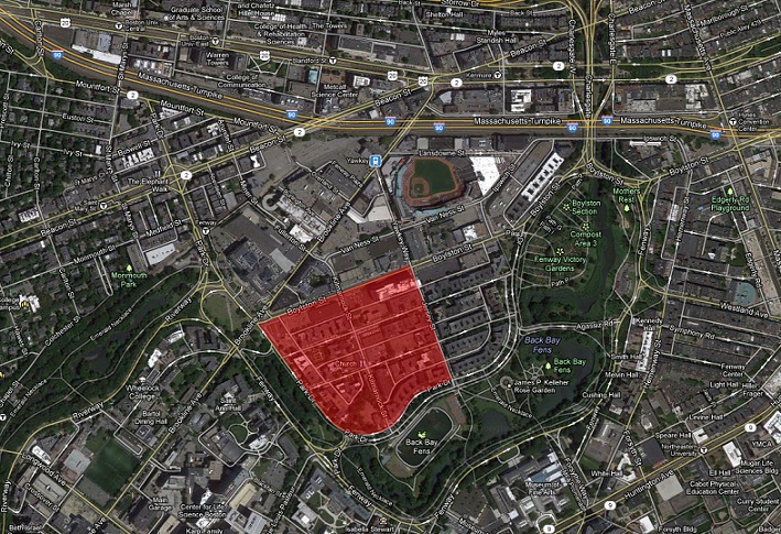
 Present day map and boundaries ("Boston, MA")
Although the changes that have been studied thus far in the previous paper happened in the past and were studied by observing maps, traces of those changes can still be observed today. These traces provide a view into the past while looking at the present day scene, and in many cases provide clues as to how the future of the area will be shaped. Based on the history of the West Fens site as well as observations made in the field, the most significant changes to this site have been a result of changes in transportation technology during the 20th century. These changes have affected both the use of buildings and land, as well as changed the way of life of the people who live in the site and the surrounding areas.
The earliest trace of growth on this site is the system of roads. This makes sense, since there is little sense in expanding a city if there is not an easy means of transportation through the area, especially at the end of the 19th century. The city’s expansion was likely fueled, at least in part, by the increasingly accessible ease of transportation. The street system which was installed at the very end of the 19th century, as seen in figure 1, is effectively identical even today. This could make sense because the streets were built at the very beginning of the invention of the car, so the streets were built appropriately for the means of transportation that is still used to this day.
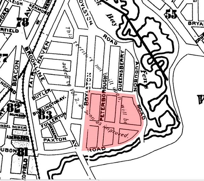 Figure 1 - A map from 1897 showing the original road layout. This
layout is almost entirely unchanged in the present day. ("Boston Insurance Maps, 1897")
Figure 1 - A map from 1897 showing the original road layout. This
layout is almost entirely unchanged in the present day. ("Boston Insurance Maps, 1897")
It is important to be aware of the state of the site in the past before analyzing present day trends, since these trends represent a contrast between the past and present. As mentioned in Urban Landscapes as Public History, during the early 20th century American cities were transitioning to becoming communities that included clusters of living buildings along with small buildings including “public bathhouses, food markets, bakeries, union halls, schools, clubs…” (Hayden, 34). This description seems to match the early development of the West Fens very closely. There were a significant number of small stores on several streets (especially Jersey Street and Kilmarnock Street), and even a school which happens to still be present today (McKinley Preparatory High School).
Perhaps the oldest trace of this initial culture formation in the West Fens is a view looking down Park Drive (figure 2). As mentioned in Crabgrass Frontiers, these apartments were built shortly after the time period (very beginning of 20th century) when upper middle class apartments were first created in American cities (Jackson, 90). The building of these apartments was a likely basis for the West Fens, and created a culture that presumably consisted almost entirely of upper middle class households. Although the appearance is most prevalent along Park Drive, the vast majority of apartments on my site have similar architectures and styles indicating that they were built at similar times (maps from 1937 would agree) , and that most if not all of the apartments are middle and upper middle class residents.
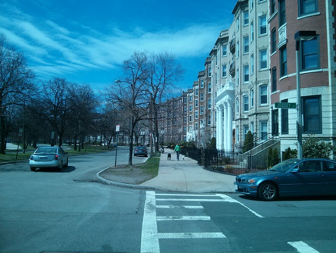 Figure 2 - A view down Park Drive showing the original buildings still
in place.
Figure 2 - A view down Park Drive showing the original buildings still
in place.
Since the apartment buildings and residents have not changed to any observable degree, it becomes necessary to look elsewhere to find traces of the past that also represent change in the site, and ultimately try to find trends that may signify changes that could continue into the future. One of the best indications of such change within my site is the change over time with regard to small convenience type stores. Many of these stores have been eliminated in favor of using the space for single larger establishments, or even using the land for entirely new purposes by constructing new buildings in the place of the old stores. An excellent location to observe several changes of this type occurring over a wide time span is on Kilmarnock Street. Along this street, there are two buildings between Queensberry Street and Peterborough Street separated by an alley way. A view of this area can be seen in figure 3, with a collection of historical maps over several different eras in figure 4. The first change that occurred in time was the transition of the subdivided building of small stores into larger establishments, and ultimately into a single restaurant and bar. Item #1 in figure 3 shows this building which has changed (Church is the name of the restaurant, and is not actually a church). The architecture of the building clearly shows each of what used to be small store fronts, which makes it a trace of the historic building use while also showing how the use of buildings of that nature have changed over the recent decades. Another change in this set of buildings is #2 in figure 3, which was once a set of small stores. Between 1974 and 1992 (as shown in figure 4), it was removed and a multi-story apartment building was put in its place, likely to meet increased demand for housing.
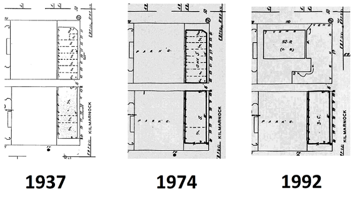 Figure 3 - A set of maps showing Kilmarnock Street in 1937, 1974, and
1992. Between the first two, a subdivision is removed within the lower storefront. Between the second two maps, all subdivisions
are removed, and the top building is completely eliminated being replaced by an apartment. ("Boston Insurance Maps 1937, 1974,
1992")
Figure 3 - A set of maps showing Kilmarnock Street in 1937, 1974, and
1992. Between the first two, a subdivision is removed within the lower storefront. Between the second two maps, all subdivisions
are removed, and the top building is completely eliminated being replaced by an apartment. ("Boston Insurance Maps 1937, 1974,
1992")
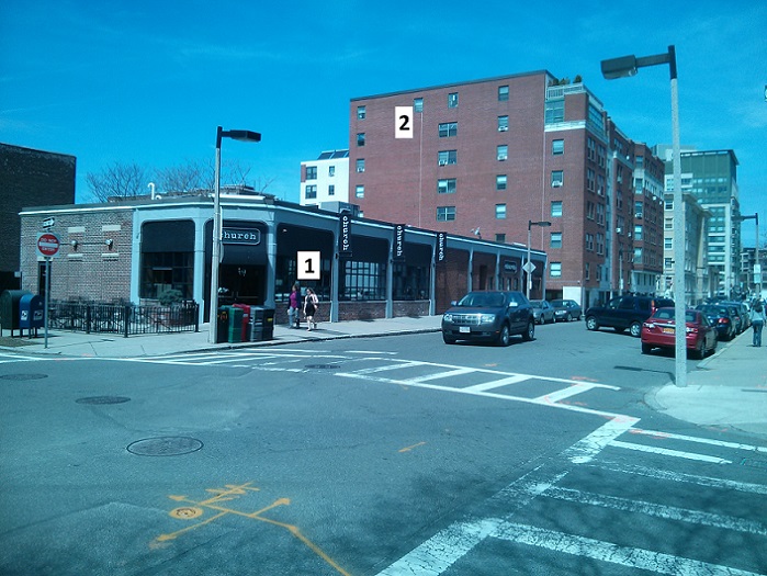 Figure 4 - A present-day view of the buildings seen in the maps of figure 4.
References to the numbered buildings are in the paragraph above.
Figure 4 - A present-day view of the buildings seen in the maps of figure 4.
References to the numbered buildings are in the paragraph above.
These changes on this street clearly represent a change of building use, but much more information than that can be extracted from the observations regarding how people were living their lives historically and how that has changed into the present day. In the early 20th century, given the easy access to a wide variety of stores within walking distance which covered almost every need of a typical person, people tended to live almost entirely in the community where they lived (of course, with the exception of traveling to work, which likely was outside the site in the case of the West Fens since it is primarily an area of living rather than industry). This created a culture of tight knit communities that lived as one. It is likely this community feel was even stronger in the West Fens, since it is isolated on many sides by the park. To anyone who lives in a city today, it is clear that with rare exceptions there are no longer tight communities within or near the city. People live more independently, and also live more of their lives away from home than was possible before car ownership became common. These changes discussed above on Kilmarnock Street agree with this change in culture. Since people started to travel further from home to do activities such as shopping, there was less demand for small community stores explaining the elimination of many of those stores. With their removal and the expansion of the population in the area, it became logical to replace some of those stores with apartment buildings.
A somewhat different instance of the impacts of transportation can be seen on Boylston Street as a trend in the type of buildings that now exist. Throughout most of the rest of my site, the change in the retail use of buildings has been limited to changes within the building rather than with the building’s exterior size and shape. A major exception to this can be seen on Boylston Street, where small buildings were completely eliminated in favor of building much larger buildings for retail and business purposes. In one case, a small battery store and service center was replaced by a larger building, which is now a Shaw’s. The change of this building occurred sometime between 1937 and 1974. On the north-east corner of the site, a set of small convenience type stores was removed to build a high-rise which is now filled with offices as well as restaurants and fast food companies. This construction project took place sometime after 1992, making it a fairly recent example of this trend. Both of these buildings in the present day can be observed in figure 5, a view looking east down Boylston street.
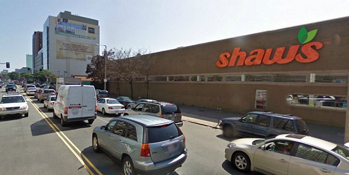 Figure 5 - Looking down Boylston Street from the northwest corner of my site.
Notice the Shaw's building as well as the highrise in the background, which are both on my site and are recent additions. The
highrise was built sometime after 1992 ("Boston, MA Streetview").
Figure 5 - Looking down Boylston Street from the northwest corner of my site.
Notice the Shaw's building as well as the highrise in the background, which are both on my site and are recent additions. The
highrise was built sometime after 1992 ("Boston, MA Streetview").
This change is significant to the culture of the West Fens, as well as the entire surrounding area, because it further reinforces the distancing of people from a close community way of life. People are drawn away from small stores in order to do their shopping at larger malls or supermarkets since it is more convenient to have both lower prices due to bulk stocking, as well as a wide selection of goods in one location. This creates less demand for small stores, creating even more demand for large stores, eventually resulting in a cycle that continually decreases the effectiveness, and ultimately existence, of small community type stores. As further evidence of this trend, just north of my site across Boylston Street is an outdoor mall of large department stores. These types of shopping centers are a fairly recent development, and will most likely continue to see growth even into the future, gradually taking yet more business away from small stores as they struggle to compete.
A final example of traces of past business as well as trends pointing towards the future can be observed on Peterborough Street. In this case, the building that was in place was a set of small community stores as shown on historical maps such as the zoomed 1937 Sanborn map in figure 8. The stores were closed down, and the building was completely renovated around 2009. The strip can be seen in its state of construction in figure 6 taken from Google Streetview, while its present day state can be seen in figure 7. Interestingly, the building was refurbished to remain a set of small subdivided establishments during this 2009 construction. They now entirely consist of places to get food, be it restaurants or fast food. As discussed in the previous paper, Jackson mentions that as automobiles were invented, the popularity of going out to eat greatly increased since it was easy to get around (Jackson, 263). This demand for places to get food evidently still continues to this day, given how recent this change was. The building still being a set of small companies leaves a trace of the past utilization of the building, while also leaving the scene a trend of how businesses have changed on the site of the West Fens.
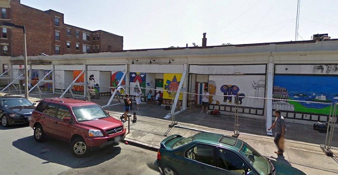 Figure 6 - A view of the strip on Peterborough Street as seen in 2009
("Boston, MA Streetview")
Figure 6 - A view of the strip on Peterborough Street as seen in 2009
("Boston, MA Streetview")
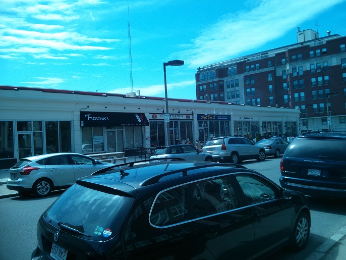 Figure 7 - The present-day view of the strip of restaurants on Peterborough Street.
These buildings were refurbished in 2009, but still have the same structure of subdivided store fronts as were originally built almost
a century ago.
Figure 7 - The present-day view of the strip of restaurants on Peterborough Street.
These buildings were refurbished in 2009, but still have the same structure of subdivided store fronts as were originally built almost
a century ago.
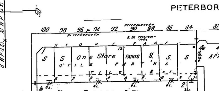 Figure 8 - A 1937 Sanborn map of Peterborough Street showing the subdivided
building, a configuration which remains to this day despite major renovations recently ("Boston Insurance Maps, 1937").
Figure 8 - A 1937 Sanborn map of Peterborough Street showing the subdivided
building, a configuration which remains to this day despite major renovations recently ("Boston Insurance Maps, 1937").
With the information collected, it is possible to make educated guesses as to how land and building use will trend in the future. Given the wide range of dates that the changes mentioned in this analysis occupy (starting out as far back as 1937) it can clearly be seen that the change from community stores to large stores and restaurants, as well as the impact that transition has on the culture of people living in the city, is a gradual change rather than being one distinct time in history. Additionally, these changes have been observed as recently as 2009 on Peterborough Street, illustrating that these changes are affecting the community up until the present. Because of this, it is very likely such changes will continue into the future. It would be reasonable to expect some of the remaining small stores to be shut down and turned into new apartments, or perhaps additional food resources.
One location where a change is likely to happen in the future is on Jersey Street at the corner with Queensberry Street. This is one of few places on the site where stores reminiscent of original community stores can still be observed. A photograph of this location can be seen in figure 9, where a seven eleven and laundry store are present, among other small businesses. Based on the trends observed in the rest of the West Fens sites, it is very likely that these businesses have a short lifetime remaining. One might argue that since these companies have existed so long that they must be stable and secure; however, no company is secure from the evolution of an entire community and culture. The changes discussed have been occurring up through even the recent years, so there is no reason the changes would cease for these companies.
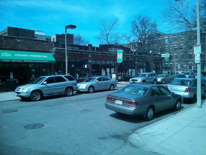 Figure 9 - The storefronts on Jersey Street. These are some of the few stores
on the site that are reminiscent of the type of stores that would have originally been in the West Fens.
Figure 9 - The storefronts on Jersey Street. These are some of the few stores
on the site that are reminiscent of the type of stores that would have originally been in the West Fens.
Examples of traces of the past in any city are abundant in quantity, since the past has been a continual process that has shaped the present day condition of the city. When looking at significant changes, it is often possible to observe patterns among them that explain something about how society has changed over time. In the case of the West Fens, the most predominant change can be explained through changes in technology, specifically transportation. Although analyzing any single trend or change might not result in a cohesive example of the area being affected by transportation, when all of the changes are analyzed together it becomes clear how they are all related to show how the area has been greatly impacted by transportation. The time ranges of the changes can also be looked at to make predictions into the future; in this case, making the prediction that the types of changes analyzed will continue into the future.
Works Cited:
Boston Insurance Maps. Map. 1897 ed. Vol. 2. Sanborn Perris Map, 1897. 0b. Print.
Boston Insurance Maps. Map. 1937 ed. Vol. 2 North. Sanborn Perris Map, 1937. 247-48. Print.
Boston Insurance Maps. Map. 1974 ed. Vol. 2 North. Sanborn Perris Map, 1974. 247. Print.
Boston Insurance Maps. Map. 1992 ed. Vol. 2 North. Sanborn Perris Map, 1992. 247. Print.
"Boston, MA." Map. Google Maps. Google, 14 Feb. 2013. Web. <https://maps.google.com/?ll=42.342408,-71.098677&spn=0.005329,0.011362&t=h&z=17>
“Boston, MA Streetview.” Map. Google Streetview. Google, Aug. 2009. Apr. 19, 2013. Web. <https://maps.google.com/?ll=42.343762,-71.100794&spn=0.000471,0.00071&t=h&z=21&layer=c&cbll=42.343762,-71.100794&panoid=j8avRt55hsKr-0Zh7trJ5Q&cbp=12,112.31,,0,6.2>
Hayden, Dolores. The Power of Place: Urban Landscapes as Public History. Los Angeles: MIT Press, 1995. Print.
Jackson, Kenneth T. Crabgrass Frontier: The Suburbanization of the United States. New York: Oxford UP, 1985. Print.