I found choosing the boundaries of my site to be one of the more challenging aspects of this assignment. When we were asked to select a site back in February, I settled on the area surrounding MGH. I was interested in seeing how such a large institution would affect the region around it, and while walking around the site I observed a multitude of other land uses within the surrounding blocks. I noticed that buildings devoted to different land uses also seemed to have different architectural styles. My interest piqued, I did a little background research on the site and found that the area had been greatly impacted by Urban Renewal. When I first drew my boundaries, I tried to include features, which represented all of these observations, resulting in a site that was far too big (figure 11). For the second assignment, on natural processes, I narrowed my site to the region closest to the river (figure 22). However, as I approached the third, change through time, I felt my new boundaries were limiting so I moved them to include a more revealing group of blocks down the road (figure 33). I hope this essay will help convey my thought process in making these decisions.
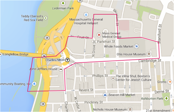 Figure 1 - Original Site Boundaries
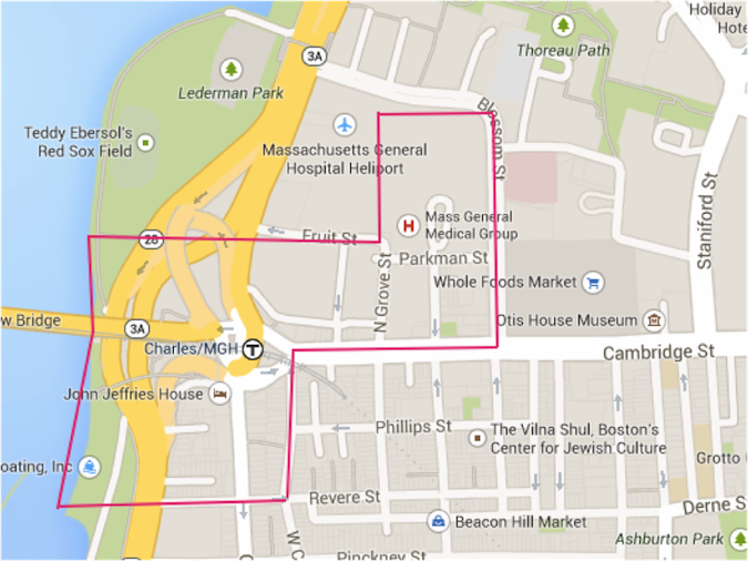 Figure 2 – Second Assignment Boundaries
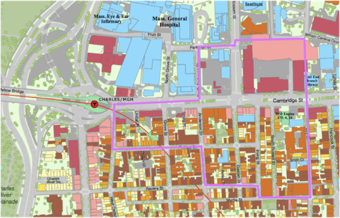 Figure 3 – Final Site Boundaries
When Professor Anne Spirn introduced this assignment in lecture, one recommendation she made was to keep an eye out for differences in land use. When I went to investigate my site, I found an assortment of different uses, including uses for institutions (MGH), transportation (the red line and Charles/MGH T stop), residences (Beacon Hill), commercial areas (Cambridge Street), and green space (the Esplanade). I was curious about how these came to occupy the same area. Which were there first and how was new infrastructure integrated into the space? I also wanted to learn more about how they interact today. The T, the Esplanade, and the commercial districts all provide services for the staff, patients, and families of MGH as well as the residents of Beacon Hill. In return, MGH most likely brings traffic and business to the area, while residents probably frequent the shops and contribute to the stores’ profits.
When exploring my site, I noticed that often the different land uses corresponded to different architectural styles. For instance, the residences and retail spaces in Beacon Hill are smaller, older looking buildings constructed from red brick. The buildings in and around MGH are of a more contemporary style and utilize glass and steel. Perhaps this is an indication of when the buildings were constructed. It is also possible that Beacon Hill tries to create the effect of an older, quainter city in order to attract tourists and stimulate the economy, as Grady Clay describes in Close-Up: How to Read the American City in his discussion of “epitome districts”. Most likely, the difference arose from buildings being erected in separate time periods and is perpetuated by efforts by Beacon Hill to preserve a historic feel and efforts by MGH to keep its clinics modern4.
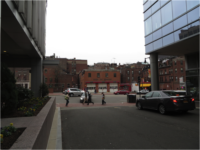 Figure 4 – Looking across Cambridge Street from the Charles River Plaza, one can see the difference in architectural styles on my site.
After reading Close-Up, I was also on the lookout for breaks, which Clay describes as visible shifts in street patterns5. As I walked my site, and when I consulted a map, I could see a difference in the street pattern between Beacon Hill and the area on the opposite side of Cambridge Street. Beacon Hill is filled with small, densely packed blocks, while the other side (known as the West End) has larger blocks of land with less regular shapes. This discrepancy could have been present since the area was first developed (due to differences in land use), or it could have been caused by a major redevelopment of one side of the street. I hoped to learn more about the cause as I researched this site over the course of the term.
In order to gain some insight into the explanations behind the characteristics I observed I decided to do some brief research into the history of my site. I learned that the region to the north of Cambridge Street was part of Boston’s old West End and was once home to many groups of immigrants, including Irish and Eastern European Jewish immigrants6. In the 1950s, however, the small residential blocks were torn down and the residents were displaced to make way for commercial superblocks as part of the Urban Renewal effort7. I thought it would be interesting to study these changes through old maps and to understand why these changes took place. I was also curious about whether I could find traces of the old West End in the current city. After a single walk through of my site, I felt like I was already beginning to see some traces, such as a sole apartment building standing in the midst of a parking lot or the historic Otis building along Cambridge Street.
It was for these reasons that I chose my general site location, but as I mentioned earlier, my original site boundaries were far too large to investigate in the course of one semester. Going into the second assignment, which focused on natural processes, I decided to limit my site to areas closer to the river, as shown in figure 2. I chose this section because I had learned from looking through maps in Alex Krieger’s Mapping Boston that much of my site lays on filled land8. Choosing a section bordering the river allowed me to explore each stage of landfill, which I found to be the most significant factor of environmental change on my site. However, entering the third assignment, which focused on change through time, I realized that the area I had chosen had not seen much change, other than transportation changes, since the late 1800s. As I was particularly interested in the impact of Urban Renewal on the area, I shifted my boundaries to the East along Cambridge Street. The current boundaries encompass both sides of Cambridge Street, one of which was changed drastically by Urban Renewal and one of which was not. I believe these boundaries give a good representation of the effects of Urban Renewal on the area as a whole, while still showing how institutional expansion and changes in transportation can impact a site.
In the end, I was able to explore a large area of the neighborhood around MGH, including parts of Beacon Hill and the old West End. In a way, I think it was helpful that my boundaries changed for assignments two and three. It allowed me to investigate the area where the most change of a specific sort could be seen. By combining what I learned from the various assignments, I could put together the story of the whole area.
1"Google Maps." Google Maps. N.p., n.d. Web. 12 May 2014.
2Ibid.
3Hayden, Dolores. The power of place: urban landscapes as public history. Cambridge, Mass.: MIT Press, 1995. Print.,17.
4Clay, Grady. Close-Up: How to Read the American City. The University of Chicago Press: Chicago, IL. 1980: pp. 11-16, 38-65
5Ibid.
6"Immigrant Era." The West End Museum. N.p., n.d. Web. 4 Apr. 2014.
7Jackson, Kenneth T.. Crabgrass frontier: the suburbanization of the United States. New York: Oxford University Press, 1985. Print., 225.
8"Herb Heidt and Eliza McClennen. Cartography By Mapworks. Scale unknown. Norwell, MA. In: Alex Krieger. Mapping Boston. MIT Press, 1999, 16-19.
Clay, Grady. Close-Up: How to Read the American City. The University of Chicago Press: Chicago, IL. 1980: pp. 11-16, 38-65
"Google Maps." Google Maps. N.p., n.d. Web. 12 May 2014.
Hayden, Dolores. The power of place: urban landscapes as public history. Cambridge, Mass.: MIT Press, 1995. Print.
Herb Heidt and Eliza McClennen. Cartography By Mapworks. Scale unknown. Norwell, MA. In: Alex Krieger. Mapping Boston. MIT Press, 1999, 16-19.
"Immigrant Era." The West End Museum. N.p., n.d. Web. 4 Apr. 2014.
Jackson, Kenneth T.. Crabgrass frontier: the suburbanization of the United States. New York: Oxford University Press, 1985. Print.