The North End is today the outcome of several driving forces and a number of trends that have predominated throughout the years. With its vast historical background, this ancient neighborhood contains several artifacts of particular relevance and traces that serve as evidence of all the changes that have taken place. It is in part the important landmarks that give a site its essence and a “personality”, but also its inhabitants and the many stories taking place in it; the ethnic and social backgrounds, its history, its traditions and all the processes that shape it. The story of North End is very rich in all of these fields and never falls short. In every corner of the neighborhood one can find several traces of the past or hints for the future.
That being said, my particular site in the North End has managed to withstand the test of time pretty well, its general structure and appearance undergoing fairly little change throughout the years. It is, for example, hard to call something a “trace” in the North End, seeing as the whole neighborhood itself is a historical place that remains, to a certain extent, in the same way that it was many years ago, thus lacking the subtlety required for something to qualify as a trace rather than solid evidence. That is not to say, however, that none exist, but rather only that one needs look closer to identify them among the overwhelming present-day image of the past that the North End is.
The Remains of Institutions
During the Site Through Time assignment, there were several general trends in my site that I could identify as constant throughout the years and relevant to its evolution. The most important one is probably the fact that the residential land use has always predominated. Being one of the very first neighborhoods in Boston, it comprises some of the oldest housing sectors of the city and it has managed to avoid industrial development and stay away from big factories, shopping malls, etc.; instead growing into an ever denser residential and small business area.
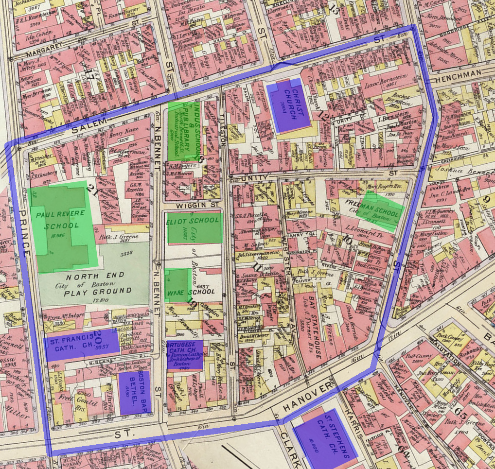 (Click to enlarge) A map of North End during 1902 showing all the schools in green and churches in blue.
Bromley, G. W. Atlas of the City of Boston, Boston Proper, and Back Bay from Actual Surveys and Official Plans. Map. 1902. MIT Lib., Cambridge. Dome. Web. 1 Apr 2014.
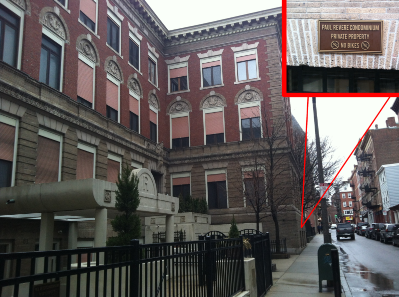
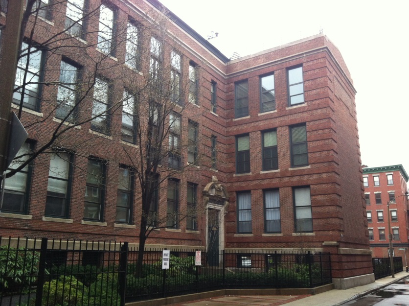 The former Paul Revere School (top) is now the Paul Revere Conodminium and the former Eliot School (bottom) shared the same fate.
Other than that, what little space is left in this highly compact zone has usually had institutional uses in the past. Churches and schools, in particular, had their respective periods when they were quite abundant. With time, however, these two have yielded to the more predominating trend of the North End as a residential area. I attribute the transient abundance of schools to a period of particular growth in the zone’s population. Indeed, the period when all the schools start popping out coincides precisely with when the tenement areas begin getting denser. A few years after the sudden growth of population, however, around the mid twentieth century, it seems like the age pyramid started settling down and the extremely high number of schools was not necessary anymore.
Out of the five schools that were present at the same time in the early twentieth century, only one remains today. In this way, schools started disappearing from the map but did so in favor of residential development. A very peculiar fact that one might notice while walking through the streets of North End is the existence of several small, compact condominiums made of a single short but wide building. As it turns out, this is actually directly related to the disappearance of all these schools. In fact, a very interesting phenomenon starter taking place, in which schools would stop serving their original purposes but the buildings themselves would remain untouched and continue to be used, unsurprisingly, for residential purposes. The transformation of schools into residential buildings thus became a general trend in the North End. The Paul Revere School, for example, which was the biggest school ever present in the site, has today been redesigned without much thought into the Paul Revere Condominium. Similarly, the former location of Eliot School has been turned into a condominium as well, and Ware School shared the same fate.
All of these buildings, however, suffered almost no change whatsoever in their facades when they underwent this change, and they still bear an uncanny resemblance to schools. The existence of these peculiar condominiums found throughout the site is thus explained by this phenomenon, the buildings that now form condominiums serving as traces of the overabundance of schools that were present in it. It also serves to illustrate once again the problem of overpopulation in the neighborhood. Having almost no industrial areas or large stores at all, the closure of a school makes available a large piece of land under a single use, which is quite hard to come by in the North End and would provide an excellent opportunity to open such establishments that the neighborhood lacks, yet this did not happen. It goes to show how hungry for residential expansion the North End is, its overpopulation forcing it to turn any open space available into housing at the first given opportunity.
Churches in the North End
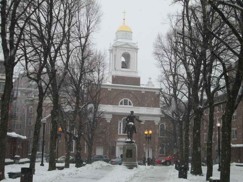 St. Stephen's Church standing right across the street form the Paul Revere Mall.
The other most common form of institutions in the North End, churches have also played very important roles on the site and continue to do so today. Some of them, such as St. Stephen’s Church and the Crist Church, are among the most ancient churches not only of the North End, but of all Boston, as they can be traced back to the oldest maps as early as the eighteenth century. These two churches are thus very ancient artifacts that serve to illustrate a predominance in the spiritual aspect of the resident’s lifestyle. Throughout the years, there were a number of Baptist Churches and even some churches associated with a Portuguese ethnicity, but these have all come and gone without staying put for more than a century. These two churches, however, have managed to flawlessly withstand the test of time and stay present throughout more than 300 years, hinting at a very strong Christian culture in the region. Seeing as the North End is well known today by its Italian culture, I consider the Catholicism predominance in Italian immigrants to have been a crucial factor in the conservation of these churches for so many years.
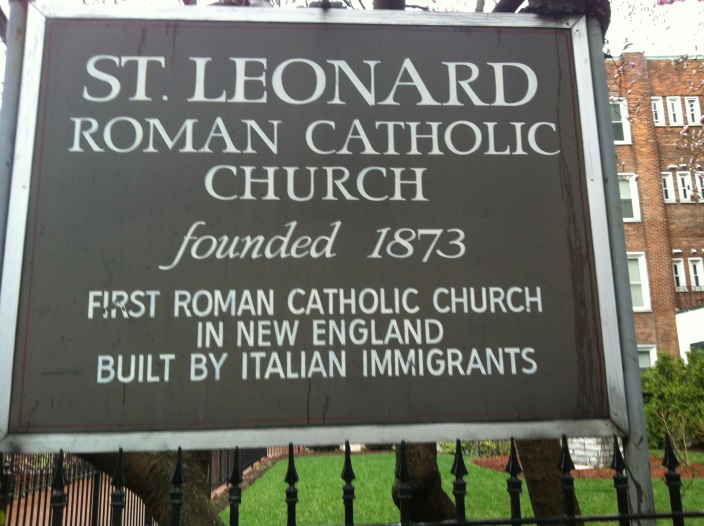
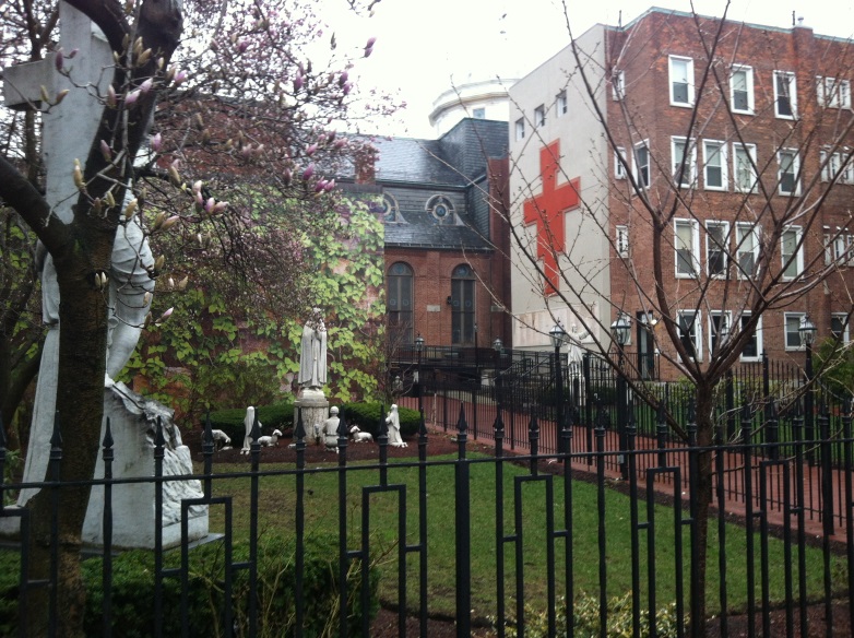 The St. Leonard Peace Garden.
The Church of St. Leonardo, on the other hand, is another example that is much more closely related to Italian culture. Built in 1873, this church was the first Italian-centered institution that appeared on the maps and is a very important artifact that stands today as evidence not only of the fact that Italian immigration played a decisive role in shaping the North End, but also of the precise date when this phenomenon started taking place, as the date is conveniently engraved on its entrance. Today, the church proudly wears a sign reading “First Roman Catholic Church in New England built by Italian Immigrants”. Although it is the only of its kind inside the particular boundaries of my site, it is certainly not the only one in the North End. The Church of St. Leonardo serves as an ancient artifact that is representative in my site of countless other Italian Churches that can be found today throughout the North end.
Annexed to the church is also what is known today as the St. Leonard Peace Garden, a decorative garden that breaks the concrete monotonousness of the North End. In his book The Power of Place, Dolores Hayden notes that “There are distinctive design traditions for outdoor spaces associated with different ethnic groups – yards or gardens planted in certain ways identify African American or Portuguese or Chinese or Latino or Italian residents” (35), and I believe that the St. Leonard Peace Garden, adorned with statues of Italian patrons, serves as a very obvious sample that exemplifies this fact and further illustrates the vast Italian cultural influence in the neighborhood.
The Paul Revere Mall
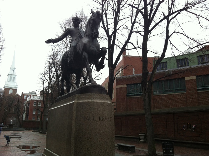 Paul Revere's statue standing at the center of the mall.
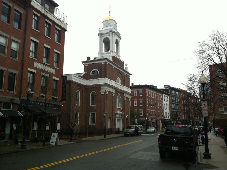
Perhaps the most characteristic landmark of the North End, the Paul Revere mall is a very important artifact that is really unique to my site in every sense of the word. Commemorating Revolutionary hero Paul Revere and standing just a few blocks away from his former house in this very neighborhood and from the famous Old North Church, this monument is not only a great part of what creates the essence and character of the North End today, but is also a material reminder of the huge historical legacy that the neighborhood holds. Its mere existence serves as evidence of the importance that the public figure has for this neighborhood and for the fact that it played an important role in the setting of the revolutionary war. Throughout the mall there are also several commemorative plaques, some of which, for example, are in honor of and contain the names of North End inhabitants who gave their lives in the revolutionary war and other more recent wars, which indicates the importance that this might have in people’s everyday life even today. Far more than that, however, the mall is a crucial aspect of the essence and physical appearance of my site. It immediately stands out as a particularly nice open place among the concrete jungle that the neighborhood is, and it is a very pleasant site where one can take a walk or sit down for a while during an enjoyable afternoon.
As noted in earlier assignments, the mall was built over a zone with a very large and highly dense tenement area – the densest in the site, in fact, so it is fairly surprising to see its construction taking place when it signified the demolition of the living places of so many people. It definitely brings up the question of just how reluctant people were to this project. Where there protests from the people living there or did they just gladly assimilate the fact? These are all very relevant question since, since they could also tell us lot about the character of the North End as a community. As Hayden mentions in The Power of Place, “It is also important to know how neighborhoods have reacted to history projects, landmark projects, or public art projects in the past: which ones succeeded, which ones failed, and why” (229).
Layers
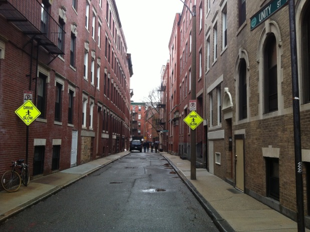
Being the huge monotonous concrete and red brick jungle that it is, it can be extremely challenging to identify different layers in the North End. The overall trend of the building style is that all constructions must have matching facades. Almost absolutely every building in my site is made of red brick, most of them are three stories high, and some might have a couple of balconies. Other than that, the buildings look almost identical to each other and it is hard to see layers representing different periods, since the construction style and materials have remained unchanged during so many years. If anything, one can distinguish between red brick buildings of different ages, as can be seen to the left in the peculiar intersection of Unity with Tileston. However, other than that, even the oldest churches are today presented in a way that completely blends in with the omnipresent red brick theme.
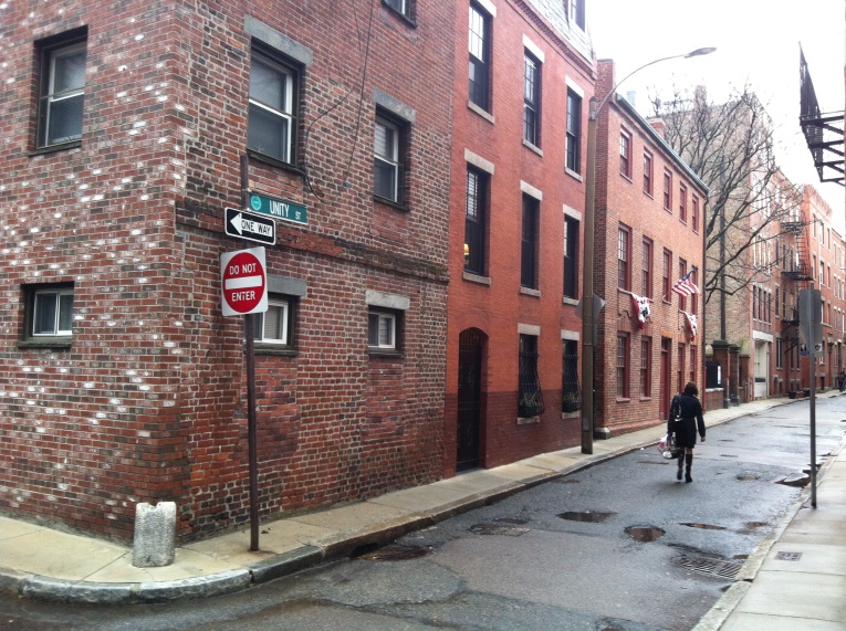 This peculiar intersection includes buildings of diverse ages forming several layers from different points in time.
 Even St. Stephen's Church manages to blend in with the red brick monotonousness of the neighborhood.
 Some of the streets in the North End are very narrow and can barely accomodate more than one car.
One of the oldest kinds of layouts, which has remained almost completely unchanged and could, after all, be considered as a layer, is the layout of the streets. All of the four streets that form the boundaries of my sites and a great majority of the streets that go through it have suffered almost no changed at all since the eighteenth century, something that is quite significant and that I attribute to my site being in the heart of North End and having been quickly squeezed and surrounded by the fast development, leaving it unable to undergo any kind of expansion or significant changes. One of the most relevant consequences of this is that streets are very narrow, something that is especially notable in Salem Street and Unity Street, for example. Today this has very undesirable consequences involving very dense traffic in the neighborhood during rush hours, but in a way this intact oldest layer of the North End also serves as a trace that can teach us a lot about the lifestyle in old days in terms of transportation. Not having been built with the use of automobiles in mind, these streets were designed to handle horse carriages at most and to favor transportation by food in a not-too-big neighborhood where people did not need to travel much.
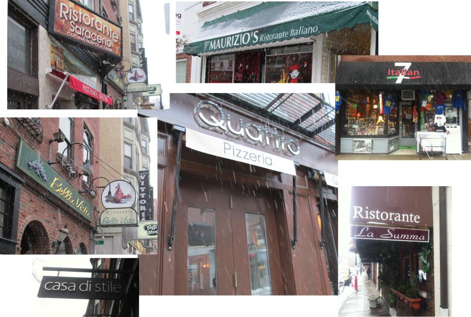 The many Italian buisnesses flooding Hanover Street.
Finally, on top of all this, there is a new overall layer over the whole neighborhood that has developed in more recent years which comprises the many Italian restaurants, gift shops, and other Italian-related small businesses that are today present in the North End, and which have started shifting it towards a place with a more touristic feel to it. Although a lot of these cannot yet be found inside my particular site, my boundaries do manage to catch a portion of Hanover Street which is crawling with them, and is representative of the global trend in the neighborhood that is a result of Italian influence.
The Future
All in all, the North end is a very rich neighborhood in both its history and the traces of it that it contains today, as well as the many ancient buildings and foundations that serve as artifacts and as perfect examples of general trends that are constant in the site. Today, the North End is the result of many years of changes but also of constant general trends in the path that the neighborhood has taken. It is not hard at all to notice the many predominating trends in the area, particularly those such as the Italian culture, the overpopulation, and its obligation to respond to it accordingly by always trying to expand its residential zones. What is not at all simple, however, is to understand the complex and dynamic changes that are always taking place, but which can be explained or at least exemplified by the several traces and artifacts found in the site.
My predictions for the North End are that it is most likely to continue on the trend of little change that it has been following for several centuries. Still compactly and densely packed by its surroundings as it was hundreds of years ago, I wouldn’t expect to see big changes in terms of the street layout, for example, or the majority of its land use being residential. What I would expect to maybe keep expanding is the Italian culture in it and the sense of the neighborhood as a touristic attraction. In particular, I can see the swarms of Italian restaurants and gift shops growing deeper inside my site as they have in the rest of the neighborhood, which could in part diminish the degree of highly concentrated housing sectors, although I wouldn’t expect it to be by a lot. I wouldn’t expect the only school left on my site to go away, although if it did at least I don’t think it would become a small condominium as the others did, but just because this one is located right in the middle of the Paul Revere Mall. Overall, however, I do expect the North End to continue as a highly residential area, perhaps with some of the buildings growing a story higher to account for the fact that I really don’t believe the housing could get any denser at the ground level; but also its touristic attractiveness and its character of a Little Italy to become even more significant with the years.
References
Hayden, Dolores. The power of place: urban landscapes as public history. Cambridge, Mass.: MIT Press, 1995.All photos by author.