01
introducing
| 02
nature
| 03
use / time
| 04
artifacts
| 05
![]() onwrds
onwrds
[
resources ]
[
citations
]
[
journals
]
![]() shift
frame to adjust focus
shift
frame to adjust focus![]()
 1
1
[_]
| PLEASE SELECT AN
EARTHWORK [TERRA FIRMA] ahistoricaltopography [TERRA COGNITO] electromagneticfieldguide |
 |
 |
|
 
|
|||
[_]
| ANATOMY OF THE NECK |
|
 |
|
|
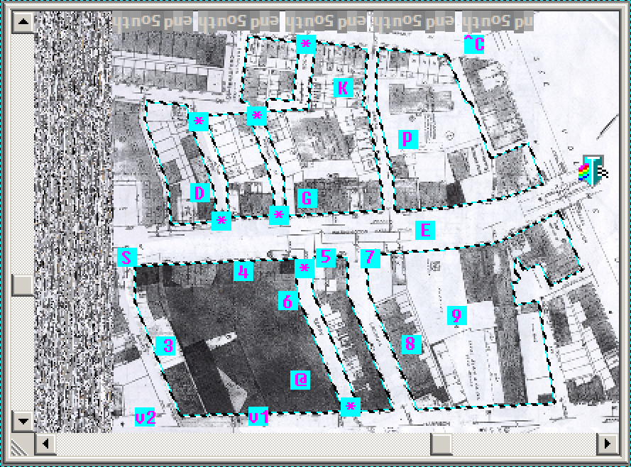
MEMORY DISPLAY QUEUE MEMORY DISPLAY QUEUE [v1] Across Harrison. Ars Libri. “Largest stock in America of rare & out-of-print books on art.” Concentration of condensed information & an attractor for a particular set of character types. [v2] Across Harrison. Large parking lot & enormous hollowed-out, vacant building shell. When not winter, lot hosts popular art & craft market in tents on weekends. Example of current temporary use & staple event for the image of “SOWA” district. What did the structure once hold? What is it being transformed into? Since SOWA stands for South of Washington, is this area contained by the highway system? Or is this the frontline for an art take-over? [3] Empty lot off Savoy. Large metal arms, jib cranes I believe, and heavy concrete blocks labeled with weights. A strange testing ground, my favorite vacancy. How oft is it used? Why the surprising lack of life? I’d expect it to be overgrown. [4] Row of single-story retail. When heading up Washington by way of the Cathedral, this appears as a large gap in the otherwise consistent rows of 3 to 5 story buildings composing the streetscape. How has this spot resisted similar development? What is the impact of this on the park? What is it like UP THERE? [5] Office front for American Crane & Hoist, 1234 Washington St. Ornament of the storefront has strange sorts of ‘ports’ that seem no longer active. In embellished stonework, one labeled OUT, the other IN. A remnant of the logistics of manufacturing past, or an indication of the mouths of former streets? [@] Factory facilities of AC&H, in suite with U.S. Monorail & Leon Electric. How long has this use been active here? What was manufactured prior, and does it continue any specific local tradition or technologic-development trend? How might these uses correlate to its geographic position on the isthmus of the Shawmut? Cranes are tools constructed to aid construction, is there something strategic in this placement? Or, and this would trump all, could this be a grand historical joke on the site’s possible prior and perhaps earliest colonial usage, the gallows? Imagine, a location that’s a concentration of talent with suspending weights from ropes, advancing quietly through all these years. Anything’s possible around the Boston Neck. Even a noose. [6] How did this kink in the shape of the lot arise? It’s similar to a “break” as Grady Clay describes, but it happens mid-block. What geographic features or events in property allotment shaped this.. shape? [7] Current location of the Red Fez, a bar/restaurant located in a typical South End corner-store location, but because it’s not built around or on top of, seems strangely islanded. [8] Parking lot; was in use as of two years ago, now absolutely vacant and haphazardly fenced off. [9] Laconia Lofts, live-in studio space for artists. I still wonder how the artists inhabiting it were initially chosen. Built to be raw space, with atypically high ceilings, such that residents could freely design their own spaces. Dodging functionalism in a sense, this new building emulates aspects that make adaptive reuse attractive. The concept has yet to be perfected, as this created a second construction phase lasting approximately 2 years after the initial construction finished. [prism] denotes a guess at the area where the city gates once stood. Was it always located here, or did it move up and down the neck? At what point did it become obsolete? Could its position have contributed to the volatility of physical forms and temporary uses outside the gates? I can imagine there being significant flux, of people coming and going, perhaps camping outside if they’re not deemed admissible. Or a style of encampment that sustained “fort” form, as opposed to the city within the gates settling down and civilizing. [*] – [*] denotes streets that are no longer present – do these manifest in any way today? There are even more of them going earlier back, if I recall the maps correctly. Did they leave any impact on topography, natural flows, people paths? [S] Savoy. Savoy. Savoy. How did this street get its name? How did it also become a club / apartment hotel further down, where Washington meets Mass Ave? Are there relevant historical associations, or is this naming somewhat random? It may have once been called South May. I believe Savoy in France is a province known for its autonomy. [E] Washington Street. If this was one of the first roads into Boston, how did the South End form around its neck? I would request this answer to be focused on the transformations occurring between established and available “snapshots” of the peninsulas growth. The Washington El was once above this street. What forces/pressures contributed most to its construction, what were the details and end-destinations of it as a dismantled infrastructure? What was the public perception of it when it did exist? [P] Peter’s Park. Ballfields, sportscourts. Popular and recently remodeled, how many other iterations have there been? How have the games changed? [G] Graffitti wall. Provided, official outlet for creative expression. Torn up at one point but rebuilt when the park was revamped. Now there is a large-scale spray-painted mural covering. Rather static, I wonder how such sanctioned spots are actually perceived by the culture that practices tagging and streetart? [D] Dog run! It’s nearly doubled in size. I can’t start asking questions of dogs, not now. But I wonder, are there more dogs playing outdoors than kids? [K] Kids playground. Recently expanded to include a tensegrity polyhedron rope structure, as well as knee-friendly rubberized ground. Both of these contribute to a world of material behaviors otherwise alien to the structures and surfaces comprising the neighborhood as a whole. [^C] Across Shawmut and along Berkeley. A visible and beckoning mouth to a VERY long stretch of community gardens. An important adjacency to consider, as it’s the closest thing to a present-day wharf extending off my site. I really just wanted to end noting an intuition and curiosity regarding the production of wharves. |
|
|
//MAP HISTORY: Corrupted .GIF saved on 4/17/2007 of a 1950 fire atlas
map, sourced from website of student in 4.211J //BOUNDARIES: The walkable path encompassing highlighted blocks, principally enclosing the large open air volume of the park & cross-street stores. As boundaries may fluctuate, maximum outer bounds may be defined in relation to Washington street. Parallel bounds: Shawmut < + > Harrison. Perpendicular bounds: Berkeley < + > Waltham //BLOCK COUNT: Indeterminate, piecemeal. Approximately 7 blocks as of 1950. Approximately 4 blocks as of 2010. //USES: Fun. Factory. Retail outlets along Washington St. flow. Residential inlets along exterior boundary. |
[_]