Tropical Cyclone Lupit
Typhoons, Cyclones, Hurricanes -- they go by different names in different places, but they're really the same thing. We'll call them cyclones in general, because it emphasizes the way they spin.

Image from eosnap.com.
Above is a video of Tropical Cyclone Lupit, which formed in the Western Pacific and passed near the Phillipines and then Japan before weakening and passing out of the tropics. The video shows the track of the storm, as well as its predicted future path at the time -- a "cone of uncertainty". The color is related to cloud temperature, which is in turn related to cloud height -- higher clouds are colder because the temperature of the atmosphere strongly decreases with height. The storm is very circular in shape, and is about 8 degrees latitude by 8 degrees longitude -- this translates to a diameter of about 880 km, or 545 miles. Tropical cyclones can be much smaller than this, but none have been seen that are more than two and a half times this big.
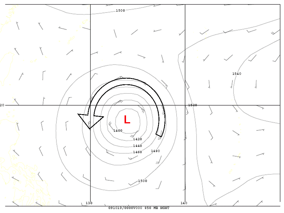
This is a less sexy contour map I made of the storm's winds and the height of the surface where the pressure has fallen to about 85% of the mean surface value -- this is a little less than a mile above the surface. This map is from the time when the storm was at its peak strength, a few days before the above video. A surface of constant pressure with a low height means basically the same thing as low pressure. The winds blow counterclockwise around the storm -- they don't flow in towards the low pressure center because pressure forces aren't the only forces acting on the moving air, and because the air can be continuously accelerated toward the center of the storm and still move in a circle. The little lines are wind barbs -- they indicate how fast the wind is blowing and this plot shows the wind in meters per second. 1 meter per second is equivalent to a little over 2 miles per hour. The strongest winds shown here are about 25 meters per second, or about 55 miles an hour. Lupit had peak winds of over 170 miles per hour at this point, but only over a very small area near the storm's center -- they have been averaged out by the grid spacing in this plot.
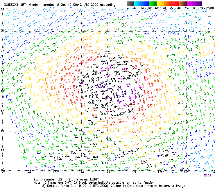
Image from QuikScat archive; Lupit was storm number 22 in the Western Pacific in 2009.
How do we know that the winds are blowing that fast? Above is a plot of the wind speeds in a much closer grid spacing, determined by a satellite. The dark purple flags near the middle of the storm show winds of up to 80 knots, or over 90 miles an hour. The strongest winds in the atmosphere are rarely right at the surface, since that's where friction is strongest, so we know the winds are even higher a little bit up into the atmosphere. The satellite figures out the wind speed at the surface based on the way microwaves reflect off the surface ocean -- the microwaves can go through thick cloud cover, so they are very useful for figuring out the winds in a cloudy storm. Unfortunately, the satellite used to make these measurements fell out of orbit a few weeks after these data were collected. RIP, QuikScat.