|

subbottom
profiler
precision
navigation
|
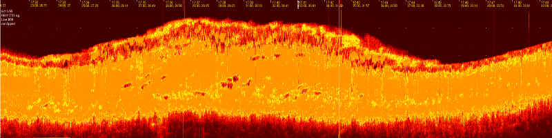
SUB-BOTTOM PROFILER
DATA: ASHKELON 1999
There's a lot
still to be said about the data, but here is a small sample of it, in
much reduced format:
- You are looking at a
cross-section of the seafloor, about 400 meters deep, made by Jason,
flying in a computer-controlled straight line about 3.5 meters above
the bottom.
-
The orange
stripe you see is the acoustic signature of a few meters of the mud
below the seafloor. The shady shape which seems to lie on top of the
seafloor is a pile of amphoras, or ancient shipping containers, about
2 meters deep.
-
The bright
and dark spots within the orange stripe, we believe, are the remains
of the structure of the ancient ship, which have been preserved because
they are buried in the mud. The dark areas indicate a density similar
to that of water, which is what one would expect from waterlogged
wood.
-
This whole
image is about twenty meters wide; the unreadable yellow text at the
top are spaced every one meter. We have such profiles at about 1 meter
spacings all across the wreck site, and are working on displaying
all the data in a single, 3-d format.
More to come!
|