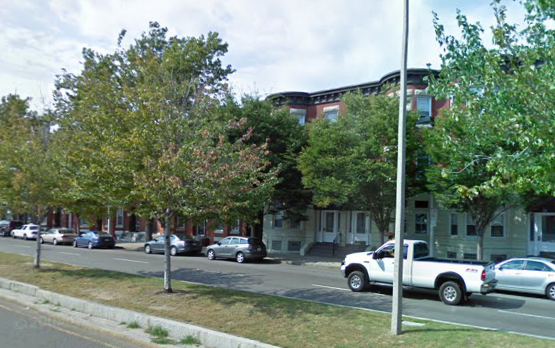
 Site boundaries. [GoogleMaps. GoogleMaps Street View. Packard's Corner Allston, MA. 2010. Google.com. Screenshot. 28 Feb 13.]
Allston is a site that has had many natural processes shape it into the town it is today. After much observation, I noticed how the vegetation interacts with the buildings, the age of the city through its pavement, and its infrastructural efficiency through its location of drains. I have thus hypothesized that the vegetation in Allston was planted in response to needs of its neighboring buildings, the area has compacted soil, and there is a lack of infrastructure for large amounts of water in my site.
 Example of street tree.
The first thing I noticed about the site I have chosen is the way the vegetation and buildings interact. The trees and buildings are very integrated with one another, and the vegetation serves a purpose for the buildings. Many of the commercial buildings in Allston are very low lying, either one or two stories tall. Only residential buildings rose to three or four stories. For many of the shorter commercial buildings, the trees were able to stretch and grow taller than the buildings. I hypothesize this is because they receive more light when not shaded by the building, and thrive beyond the buildings’ heights. However, for the residential buildings, the trees do not stretch above the apartments and instead, rise to the second/ third floors. I also notice that the trunks of the trees are much thicker, which may suggest that the trees are older than the ones planted near the commercial buildings. Preliminary research has suggested this is so because the commercial parts of Allston are newer than the residential, and were put in place of older, upscale residential housing. Thus, the area must have been redone completely in order to accommodate the new commercial buildings.
 . GoogleMaps Street View. [GoogleMaps. GoogleMaps Street View. Packard's Corner Allston, MA. 2010. Google.com. Screenshot. 28 Feb 13.]
As for the trees near the residential area, they are much larger, but do not go above the buildings. I looked at GoogleMaps for a view of the area from the summer time to notice how the trees look during a different season. I notice that the trees near the residential area during the summer, create shade on the sidewalks. Stirn confirms this observation by mentioning that “the street, sidewalk, and adjacent buildings feel much hotter, the air grittier” once these mature trees are removed (Spirn 171). I hypothesize that the trees were planted after the construction of buildings, for aesthetics as well as for shade, the way they are evenly spaced out on the sidewalks.
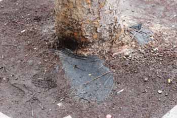 . Exposed plastic surrounding base of tree.
After focusing on the integration of the vegetation with the buildings, I took notice of the trees themselves. I looked at their age, positioning, and how they came to be. I did so by first taking a look at the base of the trees. After some erosion, a layer of plastic shows on the base of the tree, which suggests that this tree was planted as a younger tree rather than as a seed. It is reasonable to assume that these trees were imported in order to ensure their success amongst the harsh weather of the area.
As previously mentioned, the trees vary in size and age, as some near the residential area seem to be older, and the ones near the commercial areas are younger. According to Granite Gardens, “it takes more than forty years for most trees to mature; yet the average lifetime of a street tree planted today may be less than 10 years.” (171). I took notice that there was a distinctive gap between these two different ages of trees that lined residential and commercial areas. Referring to the Earth portion of Granite Gardens, Stirn provides an explanation of why these trees are rarely long- term. “Contamination and compaction of city soils deprives the city of resources. The density of city soils is … [a] primary reason for the demise of trees… The weight of the buildings, pavement, vehicles, and people compacts the soils beneath them, inhibiting the growth of plant roots, and exterminates the soil organisms”, which impacts the ability of trees to grow in urban settings (105).
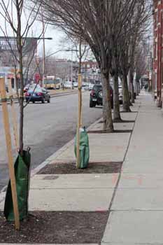 . Younger trees with structural support.
 An example of this is through the young trees recently planted on Brighton Ave. Though I believe there is a distinction in tree age in its positioning, I believe the extremely young trees that still need structural support, were very recently put in place to replace older trees that may have been blown down by the recent blizzard. This directly proves Stirn’s point of soil compaction and its connection to root growth. We conclude that these trees aren’t well rooted and rather expand their roots horizontally rather than vertically, making them more susceptible to de-rooting. I believe the soil in the squares where these trees are planted go as deep as, or a little more than, the height difference between the street and the sidewalk. Because of the inadequate space for the tree to develop, I conclude that these trees may be easily replaceable if destroyed by lack of care and thus, do not serve any historical purpose, but rather an aesthetic one to the city.
Aside from the trees that line the fronts of apartments, there are also trees that line the lane dividers of Brighton Ave. They are planted along grass as well. I believe they serve an aesthetic purpose, as well as to prevent distraction by hiding the lanes traveling in the opposite direction. These trees seem to be the same height and age as the trees in front of the residential areas, and also tower above the commercial buildings on Brighton Avenue.
 . Trees in lane divider.
 After looking at placement and relative age of the trees, I have been able to prove Stirn’s remark of city plants being a natural resource that human function influence more than natural processes in determining the location and arrangements of plants (172). With this in mind, I conclude that the vegetation of Allston serve as an artistic addition to the city, rather than a founding or historical aspect that shaped the city.
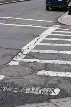 . Cracks in asphalt near medallion.
 Looking into the pavement of the area, we are also able to tell a lot about the ground on which this site stands on as well as how that affects the atmosphere of the city. Stirn argues in Granite Gardens that the compaction of city soils due to factors such as the weight of buildings, pavement, and vehicles, causes a reduction of the movement of air and water through the soil (105). On my day of exploration of my site, I noticed that there wasn’t much air flow within my area, and assumed it was because the buildings were low enough that they didn’t form a wind tunnel. However, after reading Granite Gardens, I am intrigued by the idea of Allston having extremely compacted soils, which affect both airflow and the growth of strong street trees. I notice the streets of Allston are very cracked around areas that have medallions in the ground. Most of the street is smooth, until we reach an area that has something in the ground. Looking into the physics of why this is reasonable, I can conclude that disrupting the unified material in order to add an attachment weakens the material’s bonding strength, and the area is generally much weaker around the area of the deformity or addition. We may also assume that the addition creates unlevel depressions around that area, which cause stronger and harsher forces applied by cars as they drive over the area.
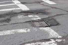 . Cracks in asphalt near grate.
 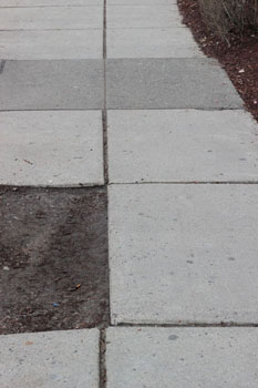 . Sidewalk tiles.
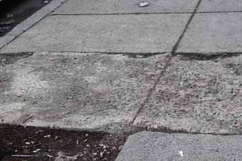
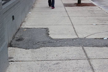 Filled in sidewalk.
 In addition to the street, I also focused on the sidewalks and their composition. Allston’s sidewalks are made up of square tiles. Though most of them are level, there are a couple that have some type of wild vegetation seeping through its cracks and create crooked or unlevel areas. There are also randomly placed tiles of darker colors, which look like they have replaced broken tiles. There are also portions of the sidewalk that are filled by asphalt. I’m unsure as to why this occurs, but wonder if it was severe cracking through previous earthquakes that could have caused a new material to be introduced into the pavement as described in Granite Gardens (page). I notice that when this occurs, the new material is much more cracked and damaged than the actual tiles it may have replaced. This may be due to the material itself, or very similarly to the case on the streets, the addition has caused elevation, which causes more force to occur at that part of the sidewalk.
 Pebbles embedded in sidewalk tiles.
 There are also other sections of sidewalk whose tiles consist of smaller pebbles embedded into the cement, and results in very unlevel, not- flat tiles. I am a bit confused as to why this phenomenon occurs, and plan on re-editing this portion of the paper after talking to Prof. Stirn about the details of this occurrence.
The overall impression of the streets and sidewalks of my site is that it is succeeds at hiding its age and erosion until unlevel or un-uniform areas. In areas where a metal medallion was inserted in the streets, the material was more cracked and worn out. Likewise, in the streets where a new material was inserted to replace an older tile, the material was much more destroyed than the original. This allows us to think about the land composition and soil compaction of the area, as well as how well the area responds to earthquakes or other types of ground erosion.
 Pile of snow from Blizzard Nemo.
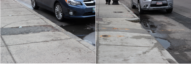
 Lastly, we observe the flow of water within the site, and how efficient the site is in handling large amounts of water. As of recent, all of Boston has been unthawing and melting the remnants of Blizzard Nemo. Thus, this was a perfect opportunity to observe how structurally efficient my site was in removing the water from the area. After my inspection of the area, I suspect that my site is ill prepared for water drainage due to its lack of efficient drains and its many stagnant pools of water lining the sides of the curb. According to Stirn’s Granite Gardens, this is quite normal for urban areas. She writes, “Floods increase … with each increment of urban growth. Rapid stormwater runoff and narrower, shallower floodplains, constricted by buildings and clogged sediment, are the cause.” (130). With those words in mind, I focused on drains and the plain levels while looking at water management and drainage.
The picture on the left shows a mound of snow melting in a parking lot. Most property owners pile snow into one area in order to clear the rest of their space. The snow is then left to melt in that area while not disturbing the activity of the area. What I noticed was where the water was collecting. There were no drains near the area, and water removal was solely dependent on evaporation. Since we are currently dealing with snow, there is no evident concern for this lack of drainage. However, in times of heavy rain, I assume there would be large puddles because of the level ground and no drains.
 Puddles of water.
 I also noticed a lot of pooling of water on the sides of curbs, with no drain to relieve the excess water. The puddles collect at the bottom of a slope from a driveway into an area. However, due to erosion of the area, the water gets stuck in large holes in the pavement, and does not drain anywhere. The puddles are large, around 3 feet wide, and has pieces of litter floating around in it. This is hazardous and stagnant water like this can lead to poisoned water.
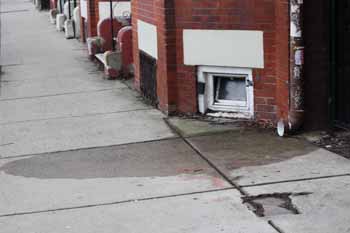 Drain from roof leading to sidewalk.
 There is also very interesting draining amongst the sidewalks. On the picture on the right, a pipe carrying rainwater from the roof ot eh building, leads directly into the sidewalk, with no drain nearby to remove the water, thus leaving a large dark, wet area in front of it. I assume that in times of heavier rain, the volume of water coming from the pipe can be quite large and gush out with a lot of force. I question why the city allows the water to flow perpendicular to the sidewalk toward the curb, instead of creating a drain to remove the water before it causes unnecessary turmoil for pedestrians. After viewing different sources of water and its drainage, I conclude that my site is ill prepared for large amounts of water influx, which can lead to increased flooding in times of heavy downpour.
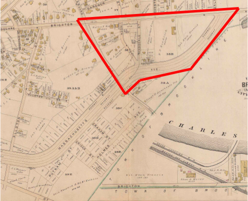 Map of Allston from 1885. [Map H. 1885. Brighton- Allston History, Boston. Bromley & Co. bahistory.org. Map. 29 Feb 13.]
 After looking at the oldest available map from bahistory.org, dated from 1885, there were no commercial buildings built along Brighton Ave where I visited for my site this week. The earlier buildings are marked by yellow shapes, which represent a “frame-built” home. The buildings are private property, most likely residential.
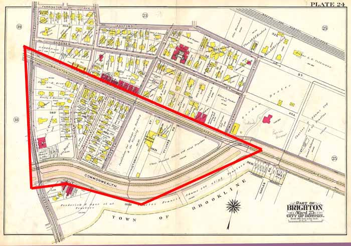 Map of Allston from 1909. [Map 24. 1909. Brighton- Allston History, Boston. Bromley & Co. bahistory.org. Map. 29 Feb 13.]
 Looking at a more modern map from bahistory.org, dated in 1909, we notice that the same strip of land on Brighton Ave is now populated by larger, red buildings, as well as many more yellow buildings. Again, the yellow buildings represent frame built buildings while the red ones represent brick buildings. From a comparison of these two maps, we can notice that the major roads that dictate my site: Harvard, Linden, Commonwealth, Brighton, Reedsdale, and Chester have remained unchanged, and buildings began to populate along those streets. Thus, the overall layout of the city remained the same, showing that not much work on the land was done to reshape it, as it has always been acceptable to accommodate civilization and urbanization.
Overall, after focusing on the history of the area, its vegetation, earth, and water management infrastructure, I have proven my hypotheses to be true. The street trees in the area have been planted for the convenience of building owners, being aesthetically pleasing and very functional in providing benefits for residents. The ground has experienced some erosion, due to soil compaction as well as natural processes and time. Lastly, the site lacks infrastructure in dealing with excess water removal.
Works Cited:
1. Spirn, Anne W. "Earth: Shifting Ground and Squandered Resources." The Granite Garden. N.p.: n.p., 1984. 91-125. Print.
2. Spirn, Anne W. "Urban Plants: Struggle for Survival." The Granite Garden. N.p.: n.p., 1984. 171-225. Print.
3. Spirn, Anne W. "Water: Floods, Droughts, and Poisoned Water." The Granite Garden. N.p.: n.p., 1984. 129-168. Print.