Today, the Long Wharf and Faneuil Hall region of Boston stands as a thriving commercial and public space at the center of one of America’s most important cities. Yet throughout its history, this has not always been the case, with the site evolving and changing through time with the city that surrounds it. Major changes in the economic landscape of the country and rapid advancements in the technology of transportation have helped to develop from the waterfront of a small colony in a new world to the bustling commercial center of the city. All of these changes have happened over relatively short time scales, and as opposed to other parts of the city, the Long Wharf and Faneuil Hall site tends to remain the same for long periods of time, with quick bursts of development scattered in between these constant stretches. It is by examining these explosive changes driven by technological and economic growth that one can better come to understand the history of the Long Wharf and Faneuil Hall region, and gain a clearer picture of where it is head
My Site in 1635
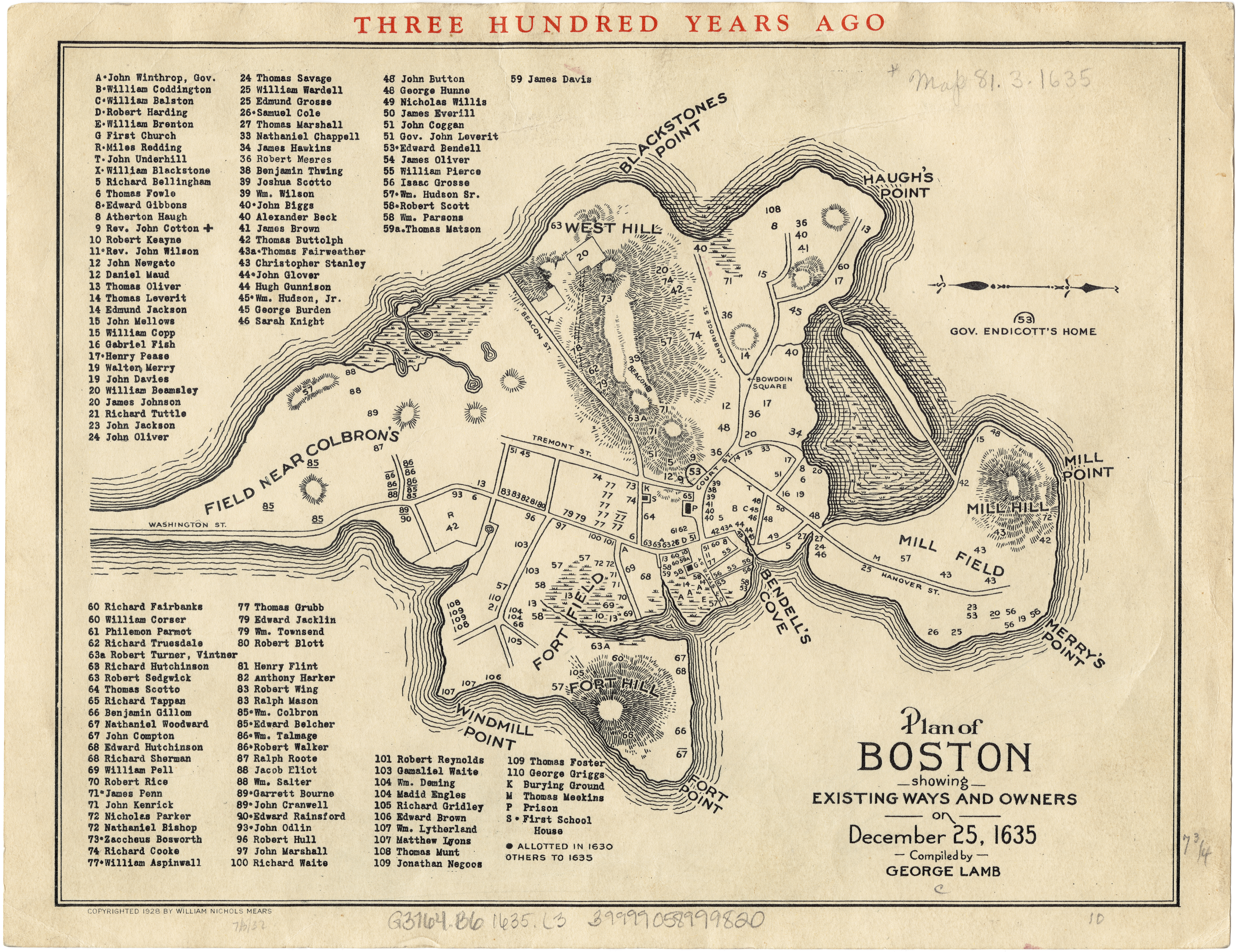 . image provided by the Leventhan Collection
My Site in 1775
 . image provided by Boston By Foot
Looking at the above maps, the first from 1635 and the second from 1775, one can clearly see that when the city of Boston was initially founded, almost everything of what would become the Long Wharf and Faneuil Hall site was completely underwater, and in a hundred and fifty years time it had developed into a full fledged city. In the 1635 map, the only segment of the area that is above the waves is the area surrounding where the State House (now known as the “Old State House”) will be built. One can clearly see that there is a building that sits at the corner of State and Washington Streets, exactly where the Old State House stands today, and with this prime location in the middle of town, one can assume that it is a town hall or another civil government building. Comparing this to the 1775 map, it becomes clear that the city and site have both developed significantly in a hundred and fifty years. The biggest development in this time has been the construction of the Long Wharf, which still stands today. This fixture has become the backbone that the entire site has developed upon; just by looking at the map it becomes clear that the Long Wharf area is the center of the city of Boston. This is perhaps the most important development of the site during its early years. With the map clearly showing the Long Wharf as the largest in the city, it becomes clear that the site developed into the city center due to its proximity to the harbor and valuable shipping and trade opportunities. It is the first part of the city that many goods shipped through the Long Wharf will enter into when they arrive, and the last holding point before goods leave the city. The best supporting sign of this large trade influx would be the T Wharf, which has been built as an addition to the Long Wharf to increase its capacity. As opposed to expanding another wharf in the city, planners at the time found it much more profitable to further expand the Long Wharf, clearly showing the sites importance as a center of the economy and trade.
My Site in 1867
 . image provided by Sanborn Maps
 . image provided by Sanborn Maps
After the Revolutionary period, the site remained much the same until the Industrial Revolution was in full swing in the mid nineteenth century. It was in this era that the first major jump forward in the site happened in the 1860s, with the filling of a large area of land to create the Quincy Marketplace. Analyzing the maps above from 1867, one can begin to look into what cause this rapid expansion of the site. First looking at the Wharf, it becomes clear that it is still the main economic engine of the site, if not the city. Comparing the 1867 map to the previous one from 1775, one can see that the T Wharf has been significantly expanded, implying an even greater need for the shipping capacity it provides in the area. There are also a large number of buildings that stand on the Wharf. Due to the low quality of the initial 1775 map, it is hard to tell if these structures are new or not, but considering that the land fill that created Quincy Marketplace has also expanded the area at the base of the Wharf, and combining that knowledge with the warehouses that lie both on the Wharf and the newly filled land, leading one to believe that they had been newly constructed. Looking at the warehouses more closely on the map, they appear to have a number of very modern businesses at the time, like oil and drug facilities. This expansion of the warehouse facilities shows that the Wharf was still bringing in a large amount of trade that needed to be stored before it could be distributed throughout the whole of the city. Taking this into account, it is no surprise that the Quincy Marketplace had just been built adjacent to the Long Wharf. The most drastic change that had happened was clearly the massive landfill project that had taken place, along with the construction of the Quincy Marketplace. The new heart of the site became the brand new storefront buildings, stretching parallel to North and South Market streets filled with small businesses. Looking at the 1867 map of the Marketplace, one can see that a number of the shop spaces are filled with smaller companies like the “Horse Radish Factory” and the “Chair Painting” businesses. In addition to this, a large number of the shops are classified as Businesses on the maps, but they all appear to be filled by renters and owned by different people. This implies that the shops are all small and personally owned businesses of all types, and with the recently built warehouses and expansion of the Wharf, its easy to imagine that the shops are selling all the possible different goods that flow in through the Wharf. This paints the picture of a site that is the thriving center of Boston, with trade flowing in and out to fuel a bustling market district and commercial heart of the city.
My Site in 1895
 . images provided by Sanborn Maps
 . images provided by Sanborn Maps
 . images provided by Sanborn Maps
Moving forward in time to 1895, one can see through the Sanborn Maps that the Marketplace is still a thriving commercial center of Boston. On these maps, it appears that more of the shops have been able to purchase the property that they use, as opposed to renting it out, like what was seen in the 1867 maps. This could easily be a signal of an increased prosperity in the shops that occupy the Marketplace storefronts, as their profits go up they were finally able to purchase the property their business uses. The Marketplace was a bustling commercial heart of the city at the time, despite the rapid expansion of Boston through landfill elsewhere. Somehow this central location had managed to grow while people began moving into the Back Bay and other new and fashionable areas, and Jackson offers a clue in The Crabgrass Frontier:
In 1815, even in the largest cities, only one person in fifty traveled as much as one mile to his place of employment. Because the business day was long, and because any distance had to be overcome by horse or foot, there was a significant advantage in living within easy walking distance of the city’s stores and businesses (29).
Boston is the epitome of a walking city, and this helps explain how the Marketplace was still able to thrive, despite the expansion of the cities borders. With the lack of public transportation clear on the map, it becomes evident that a lot of the success of the Marketplace that fueled much of its continued growth to 1895 came from the citizens of Boston who lived in the middle of the city and could easily walk to the Marketplace from their homes. The map shows it as a very pedestrian friendly area, with the Faneuil Hall Square lying on one side of the Marketplace, which would bring in even more people, further strengthening the economy of the site. This growth was also helped along by the further expansion of landfill on the site and the creation of even more warehouses to store the goods that were imported and exported through the Long Wharf. Looking at the difference in 30 years between the Sanborn maps, it becomes clear that an entire segment of the site has become completely dominated with warehouses for different trade goods. The entire middle section of the site is dominated by buildings all denoted for storage on the map, with the names of the owners like “Western Dressed Beef”. The biggest addition to this part of the site, though, is the rail line along Atlantic Avenue that pops up some time between 1867 and 1895. This rail line runs along the coast, seemingly serving all of the wharves, and even branches off into one of the major warehouses on the site. This shows that business and trade are still booming enough that the goods from the Long Wharf need to be shipped throughout the entire Boston area. All of this shows that the Long Wharf and Faneuil Hall area had reached new heights in terms of prosperity and development. It had become a economic powerhouse at the heart of the city, supplying the citizens of Boston with the goods they needed either through the shops of the Marketplace, or through shipments to other parts of the city from the Wharf and warehouse district. The site was entirely unrecognizable to anyone who had been there even a hundred years before, and comparing it to the original map, one would think that the two showed different places, yet this rapid development and growth was not to last.
My Site in 1938
 . images provided by Sanborn Maps
 . images provided by Sanborn Maps
 . images provided by Sanborn Maps
As the Nineteenth century became the Twentieth, the Long Wharf and Faneuil Hall site entered a new period in its history. Within the first few decades, it became clear that the Long Wharf and Faneuil Hall area would not be continuing the explosive growth that it had sustained through the 1800s. In 1938, the site had hit some hard times, along with the rest of the nation, that are very evident in the Sanborn Maps provided above. The most visible change is the loss of a large portion of the businesses in the area. The Quincy Marketplace has transitioned from thriving business heart of the city to mainly a storage facility. Some of the businesses still survive, but most of the shops now sport the “S” for storage on the Sanborn map. Even the central Marketplace building has been converted into a warehouse facility. One can also see a decline in nonperishable goods coming into the port by comparing the different warehouse businesses between 1895 and 1938. This shift definitely has some to do with the Great Depression, but could also be a direct result of the loss of a lot of small businesses in the area that dealt with these goods. When those businesses disappeared between 1895 and 1938, so too did the warehouses they required to store their goods. With this open space, the perishable goods stepped in, as they already used many warehouses, and the people who live in the city always need to eat. This decline in the economic diversity of the Long Wharf and Faneuil Hall region was a huge hit, converting almost the entirety of this historic and important area of the city into nothing more than a glorified warehouse district. It is this decline that would eventually bring the most dramatic change that the site has ever seen.
My Site in 1974
 . images provided by Sanborn Maps
 . images provided by Sanborn Maps
 . images provided by Sanborn Maps
After World War II America went through some very profound and radical changes in the economic, technological, and cultural aspects of the country. Looking at the Sanborn maps from 1974, these changes almost stand up and shout at the viewer. The most radical change that one will notice is the eradication of the warehouse district. Where there were once dozens of buildings that house the produce and goods that came into the city through the port, in 1974 there stood only the Central Artery. All other structures had been bulldozed as part of the Interstate Highway Act in 1956. The Long Wharf and T Wharf are both entirely devoid of the shipping warehouses and offices that once covered the length of the piers, save for the Customs House Block and Chart House on the Long Wharf. The one redeeming difference between 1974 and 1938 lies in the Quincy Marketplace. Comparing the maps, one finds that the commercial aspect of the Marketplace has begun to rebound, with approximately a fourth of the storefronts taken up by businesses as opposed to storage facilities. Even the central building in the Marketplace has been recovered from the storage facility it had been turned into, now standing as an office building. But these changes and the general decline of the entire site has been driven by technological changes in transportation have culminated in the Central Artery devastating a full third of the site. With the advent of the automobile, a push to live outside of the city had begun that would draw residents away from living in the city center and more towards the periphery. This draw coupled with the decline of the sites economy left it as an area of the city of little value. And as Jackson tells us, more powerful groups were rising to redevelop the American urban landscape to better suite there needs:
By the mid 1950s, it [the American Road Builders Association] had become one of the most broad based pressure groups, consisting of the oil, rubber, asphalt, and construction industries; the car dealers and renters; the trucking and bus concerns; the banks and advertising agencies that depended on the companies involved; and the labor unions. On the local levels, professional real estate groups and home-builders associations joined the movement in the hope that highways would cause a spurt in housing turnovers and a jump in prices. They envisaged no mere widening of roads, but the creation of an entirely new super highway system (273).
This push to redevelop parts of the city lead the government to mark the warehouse district of the Long Wharf and Faneuil Hall site for demolition, as the shipping industry began to move out of the site, almost certainly due to the advent of larger shipping vessels that happened after WWII. These changes left the site crippled and cut in half, with few ever thinking that it could recover, but the Long Wharf site would soon surprise everyone.
The Current Boundaries of my site
 . images provided by Boston Redevelopment Authority
This push to redevelop parts of the city lead the government to mark the warehouse district of the Long Wharf and Faneuil Hall site for demolition, as the shipping industry began to move out of the site, almost certainly due to the advent of larger shipping vessels that happened after WWII. These changes left the site crippled and cut in half, with few ever thinking that it could recover, but the Long Wharf site would soon surprise everyone.
As the suburban world begins to experience unmistakable signs of decay, both central cities and rural areas are making a comeback. Although statistics of population, jobs, and income [in 1985] do not support the thesis that a back-to-the-city movement has reversed the century-and-a-half-old suburban trend, the gentrification of older neighborhoods may be the harbinger of major demographic changes in the next two decades… Since 1965 important sections of Boston, San Francisco, Philadelphia, Savannah, and Baltimore have witnessed a reversal of the typical urban growth model as upper-status newcomers have replaced lowerincome households… Even Los Angeles, which has long been satirized as a city without a center, has begun developing a true, high-rise downtown business-district. Population density increased almost 40 percent between 1950 and 1980, and there is a palpable sense of energy downtown (341).
Throughout the past 40 years almost, the Long Wharf site and even the entirety of downtown Boston has seen a major revitalization. Just looking at the land use map, one can see that the entire site and the areas surrounding it are all very expansive commercial districts, and a walk through the site would easily tell anyone that the area is increasingly successful as a business district and as a pedestrian space for all. All of this is due to this reversal of suburbanization that caused the initial decline of the site. It appears that, just as in the beginning, the site thrives because of the easy accessibility of the Marketplace to its patrons.
The Long Wharf and Faneuil Hall site has gone through some drastic changes throughout its history, but today it is once again the bustling city center it was over a hundred years ago. Looking at the changes throughout time, it becomes clear that the site thrives and suffers with the greater city of Boston. It grows rapidly and its economy surges through the Nineteenth century with the city, and its businesses suffer and decline throughout the middle Twentieth century as people leave the city for the suburbs. Today though, as the city once again surges forward, the Long Wharf site is leading the push forward. It is the place where the city of Boston first grew forth from, and it will always hold sway over the city because of this. The future looks bright for the site, with the area constantly being improved and the surrounding area redeveloped, it only seems that the site can continue to grow. And as long as the Long Wharf and Faneuil Hall site is doing well, the city of Boston will also have prosperity ahead of it.
Works Cited
Jackson, Kenneth T. Crabgrass Frontier: The Suburbanization of the United States. New York: Oxford UP, 1985. Print.
Fire Insurance Maps from the Sanborn Map Company Archives Late 19th Century to 1990. Map. New York: Sanborn Map & Pub., 1867. Print.
Fire Insurance Maps from the Sanborn Map Company Archives Late 19th Century to 1990. Map. New York: Sanborn Map & Pub., 1895. Print.
Fire Insurance Maps from the Sanborn Map Company Archives Late 19th Century to 1990. Map. New York: Sanborn Map & Pub., 1938. Print.
Fire Insurance Maps from the Sanborn Map Company Archives Late 19th Century to 1990. Map. New York: Sanborn Map & Pub., 1974. Print.
"Historical Maps - 1775" Boston By Foot -. Boston By Foot Inc., 2011. Web. 10 March 2013.
Lamb, George. "Plan of Boston Showing Existing Ways and Owners on December 25, 1635." Map. Norman B. Leventhal Map Center. Boston: Norman B. Leventhal Map Center, 1903. N. pag. Print.
"Historical Maps." Boston By Foot -. Boston By Foot Inc., 2011. Web. 10 March 2013.