Introduction
Definition of Life
Motivation
Preliminary
Steps
Present Life
Past Life
Geological Survey
Sample Collection
Spectroscopic Analysis
Organic Analysis
Biology Experiments
Thin Section
Isotope Analysis
Experimental Design
(Technical Specifications)
Motivation for Geological Survey
It is generally accepted that the prospects for life on the
surface of Mars today are rather limited. The
intense radiation and thin atmosphere, combined with likely oxidizing
conditions, make surface life unlikely. In the past, however, these conditions may have been
different, producing fossils of ancient life forms.
In addition, conditions today below the surface may allow life to exist
in frozen soils and deep aquifers. Thus,
it would be essential for a mission searching for signs of past and present life
to drill beneath the surface.
However, it is not enough to merely bring a drill.
If the astronauts on the mission do not know what lies below the surface
before they drill, they may well miss important fossiliferous or life-bearing
strata, such as salt domes, sedimentary strata, and aquifers.
Thus, it is crucial to conduct a geological survey before drilling, to
determine where these features are located so that they can be sampled with the
drill.
Constraints
The geological survey must be able to identify arbitrary
strata and structures down to a depth of 100 m. The horizontal resolution must be sufficient to accurately
predict the strata for 100 m below an arbitrary point to within a few meters,
and to accurately predict the nature of all of the strata sampled by the drill.
The survey apparatus, meanwhile, must be small and light.
The complete apparatus must fit in a maximum of four MTS trailers, towed
behind the rover, and have a maximum operating mass of 200 kg.
It must be able to be powered by the rover as well.
In addition, it should be easily moveable, either by hand or by towing
behind the rover while in use.
Options
Seismic reflection: A seismic reflection
survey measures how long it takes seismic waves generated by some seismic source
on the surface to reach an array of detectors, also on the surface.
The seismic waves travel downwards into the ground, and reflect off of
the boundaries between strata. These
boundaries can be located by analyzing the signals recorded by the detectors.
This type of survey requires relatively little equipment, equipment that
also happens to be very robust. It
is also very accurate, capable of resolving the subsurface to a resolution of
under a meter. It has the
disadvantage of being manpower-intensive, and using high explosives.
Seismic refraction: A seismic refraction
survey uses the same apparatus as a seismic reflection survey, but uses a
different property of seismic waves to image the subsurface. Rather than detecting reflections of seismic waves, it
measures the time taken for seismic waves to travel along the boundaries between
strata. This survey type, however,
requires more knowledge about the nature of the subsurface in order to interpret
the data. In particular, the
interpretation of its results requires knowledge of the speed of sound in the
subsurface material in order to separate the various boundaries and determine
which boundaries are at which depths. It
also shares the problems of seismic reflection.
Ground-Penetrating
Radar: GPR is a newer
technology than seismic reflection, and is often able to achieve a higher level
of detail. However, as a newer
technology, it is considerably less reliable than seismic reflection.
In addition, it is able to examine only very shallow depths, potentially
missing strata at the bottom of the drill’s 100 m range.
Gravity:
A gravitational survey can provide a very accurate and detailed picture
of the subsurface strata. However,
it requires a very detailed knowledge of the normal gravitational field,
including influences from nearby mountains and valleys.
While the basic structure of the Martian gravitational field is known
from Mars Global Surveyor, the detailed contributions from the topography are
not known in sufficient detail to measure rock strata.
Electromagnetic
surveys: These surveys measure the local magnetic and electrical fields at
the surface to determine the presence of certain structures and features of the
subsurface. In particular, magnetic
surveys can locate magnetic minerals and iron deposits, while electrostatic
surveys can locate minerals and objects with high electrical conductivity.
We are not necessarily interested in these particular features, however,
and Mars’ lack of a strong magnetic field hampers the use of a magnetic
survey. Fossil-bearing strata do
not necessarily have differing electrical conductivities from other rocks, so an
electrostatic survey cannot distinguish such strata.
While an electrostatic survey can find underground water, which has a
high electrical conductivity, its inability to examine dry fossil-bearing strata
makes it less useful than seismic reflection.
Choice
We decided to use a seismic reflection survey due to its
high ruggedness and reliability. While
it is somewhat manpower-intensive, it can still easily be done by two people.
Using a remote-controlled explosive deployment method can mitigate the
safety risk involved in using high explosives.
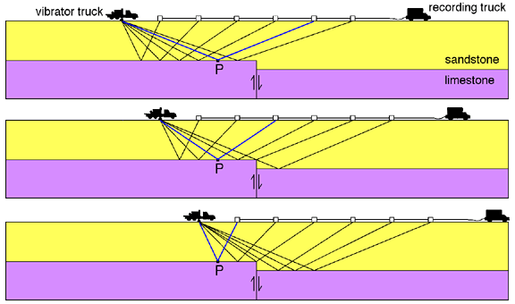
Principles of operation
A seismic reflection survey has three elements: a source of
seismic waves, an array of seismic detectors, and a computer.
The basic setup consists of a long string of seismic detectors, called
geophones, towed behind a vehicle carrying the computer.
Behind the string is the seismic source.
Geologists use three different things as seismic sources: large vibrator
trucks, modified shotguns, and high explosives.
High explosives are ideally suited to a Martian survey—they are small,
light, and very powerful sources of seismic waves.
Modified shotguns are far less powerful, and vibrating trucks are
impractical on other planets.
A survey consists of a series of measurements, called
shots, along a long straight path across the site.
Each shot begins with the laying of explosives behind the string of
geophones. This task can be done by
a robot to mitigate human safety risks. The
computer then remotely detonates the explosives.
The explosion generates seismic waves, which are essentially sound waves
in the ground. These waves travel
away from the explosion, radiating though the ground.
Whenever the waves encounter a boundary between two different strata, a
portion of the waves are reflected back upwards towards the ground.
This reflection occurs because the two strata have different speeds of
sound. The situation is analogous
two a boundary between materials with different indices of refraction in optics.
The returning waves are then detected by the geophones along the string,
and recorded by the computer. The
entire apparatus then moves forward for the next shot.
As the apparatus moves along the path, each point along
each boundary is sampled by reflections arriving at different geophones, as
indicated in the diagram. The
results for all of the shots can be processed by the computer to give the
locations of the boundaries between strata, as well as the speeds of sound in
the strata.
Equipment
| Item | Cost | Mass |
| high explosives | insignificant | 50 kg |
| detonators | insignificant | 5 kg |
| explosive-laying robot | ~$10,000,000 | ~30 kg |
| geophone chain | ~$1,000,000 | 50 kg |
| computer | ~$100,000 | ~5 kg |
Protocol
- The
astronauts will find or clear a path the length of the area to be
investigated, along which the rover can drive in a straight line without
hitting large rocks.
- The
rover is driven on this track so that it is 120 m from the beginning, facing
the other end of the course.
- The
astronauts will detach the trailer with the robot and explosives, and load
the explosives into the robot. It
is then driven aside until it is needed.
- The
geophones, all strung on a 100 m cable at 5 m increments, are unrolled from
the next trailer to their full length. The end of the cable should be attached to the computer,
which can be carried on the rover itself or stored in another trailer.
See the diagram above for an approximate depiction of this setup.
In our case, the recording truck will be the rover and the explosives
will replace the vibrator truck.
- Each
geophone is driven into the ground in position. If the ground is soil, they are simply pushed in; if it
is solid rock, a hammer and pick are used to make a starting hole before
driving in the geophones.
- The
astronauts now clear the area, and drive the explosives robot to a point 20
m directly behind the last geophone. It
lays a small explosive charge, and is driven at least 20 m from the
explosives. This assumes that
the explosive charge has a blast radius of 20 m or less—if the blast
radius is larger, then the distances will have to be greater.
- The
explosives are detonated by the computer, over a simple radio link.
The computer receives the data, and stores it on hard drive.
- The
geophones are pulled up, and the rover drives precisely 5 m forward.
- Repeat
the process, from the point of driving in the geophones, until the rover
reaches the end of the track.
- Transmit
the results back to home base, and pack up the equipment.
Use of this experiment
Such a survey should be conducted in any location where
drilling will be conducted. If the
drill is placed along the survey line, then the survey should provide an
accurate representation of the material being drilled through.
At the home base, or additional areas of geological interest, multiple
survey lines can be used to characterize the 3-d structure of the subsurface for
purely geological interest and examination.
Time for experiment
1 day per line