Introduction
Definition of Life
Motivation
Preliminary
Steps
Present Life
Past Life
Geological Survey
Sample Collection
Spectroscopic Analysis
Organic Analysis
Biology Experiments
Thin Section
Isotope Analysis
Experimental Design
Before we can begin to collect samples or drill on the surface of Mars, we first have to find out what we're dealing with. This involves a fairly detailed geological survey of the landing site and any remote drilling sites. While this takes time and resources, it prevents the far greater waste of time involved in drilling to a great depth only to miss an aquifer by fifty meters. Fortunately, it is possible to conduct a geological survey on Mars with almost the same rugged field equipment used for geological surveys on earth.
The main survey tool that can help to identify prominent underground
strata and features is seismic reflection, a method which can identify
the sizes, shapes, and approximate compositions of rock strata.
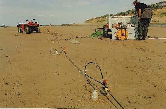
This image shows a seismic reflection survey being conducted on a beach in Wales. Basically, a seismic reflection survey relies on three things: a source of seismic waves, an array of sound detectors, and a data processing and collecting unit. An image of the subsurface structures can be obtained by analyzing the time it takes for the seismic waves generated by the source to be detected by each detector. For a detailed description of this process on Earth, consult the links at the end of this page.
Bringing a seismic reflection survey to Mars should be little more complex than conducting a similar survey on Earth. The first component, the seismic source, can easily be realized using a common seismic source on Earth -- high explosives. As little as 100 g of high explosive is sufficient to prepare a clear image of the rock below. Modern explosives are very safe and reliable, and some forms are available that can withstand the surface environment of Mars. To minimize the safety risks to the astronauts, a remotely-controlled robot can lay the explosive and set the detonator.
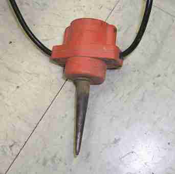 The seismic detectors
used on Mars can be practically identical to those used on Earth.
Standard geophones are rugged devices that are strung on a cable, with
spikes that are driven into the ground (see image). If the plastics
used in their construction are replaced by vacuum-safe materials, they
are ideally suited to surveys on Mars. If necessary, a simple hand
hammer and spike can be used to make holes in bedrock to accommodate the
geophones, but they behave perfectly well when simply embedded in soil.
The geophones will be mounted in a manned rover trailer, at 5-meter intervals
on a cable approximately 100 m long.
The seismic detectors
used on Mars can be practically identical to those used on Earth.
Standard geophones are rugged devices that are strung on a cable, with
spikes that are driven into the ground (see image). If the plastics
used in their construction are replaced by vacuum-safe materials, they
are ideally suited to surveys on Mars. If necessary, a simple hand
hammer and spike can be used to make holes in bedrock to accommodate the
geophones, but they behave perfectly well when simply embedded in soil.
The geophones will be mounted in a manned rover trailer, at 5-meter intervals
on a cable approximately 100 m long.
The analysis equipment can also be little different from standard equipment. The analysis computer can be mounted in a trailer for the manned rover, and powered from the rover's power supply. It should be quite light and have a low power requirement, and it will have the ability to transmit data back to the habitat.
This is a general model for the procedure: First, the crew will select a straight and relatively debris-free path about 1 km long at the site to be analyzed. The rover will be driven to one end of the path, then turned around and driven for about 120 m. The geophone cable will be deployed, and each geophone will be driven into the ground. The explosives will then be deployed at the far end of the field, approximately 20 m from the end geophone. The detonator will be controlled by radio from the analysis computer. When all is clear, the explosive charge will be detonated, and the data collected by the geophones will be compiled by the analysis computer. The geophones will then be removed from the ground, and the rover will drive 5 m forward. The geophones will be returned to the ground, and an explosive charge will be deployed 20 m behind the last geophone. It will be detonated, and the process will continue until the rover reaches the end of the path. The data analysis computer will transmit its results back to the habitat using the rover's communication system, and the crew will return to base. The resulting plot of subsurface features, called a seismic section, can be used to find a promising location for future drilling.
Technical specifications for geological
survey
Links for more information
www.litho.ucalgary.ca/atlas/seismic.html
www.geosphereinc.com/seismic.htm
www.microgeo.com/service/reflect/reflect.html
www.earth.ox.ac.uk/~tony/watts/formula3.html
www.terradat.co.uk/seismic2.html
www.geop.ubc.ca/Lithoprobe/wnew/seisrefl.html
www.ldeo.columbia.edu/~menke/lithosphere/sonar/sonar.html
www.sfu.ca/earth-sciences/courses/307/3-Seismic_Reflection.htm
www.geophysics.co.uk/methods.html
www.kgs.ukans.edu/Geophysics/shalseis.html
www.technos-inc.com/Surface.html