Before engaging in research at the Blue Hole, a firm geological background must be in place. Considerations in the complexities of the water conditions, climate, barrier reef, and seismology must be explored.
Water Conditions in the Reef
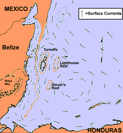
In the western caribbean, the surface currents are north and generate a thin counter current which is found in front of the barrier reed and around the atolls of Belize. Between the barrier reef and the mainland, the currents are south. Tradewinds and the emptying of the many coastal rivers generate a head of water which is funneled to the south.
Bathymetry
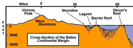
Northern part of shelf: - Enclosed by a low karsted exterior of flat-lying Cenozoic and Cretaceous carbonates. There are only a few small waterways draining on top of the layer.
Inner shelf: A plane shallow depression that is seldom deeper than 8m.
Southern part of shelf: - Flanked by the Maya Mountains. The Maya Mountains are enclosed by a coastal level surface of terrigenous clastic sediments through which many rivers run onto the shelf.
Inner shelf: Reflects the mainland landscape. It gets deeper to the south from 20-25 m to over 200 m in the Gulf of Honduras.
Entire margin of the shelf: A raised barrier 3-10 km wide and seldom deeper than 3m. The steep seaward border of the barrier is rounded by a nearly continuous coral reef. The open plane is scattered with tiny sand cays. The barrier gets smaller to less than 100m near its southern end and ends as "a hook shaped structure in the Gulf of Honduras."
Visibility: 50- 150 feet
Water Temperature: - Fairly constant all year, between the mid to high 70's to the low 80's.
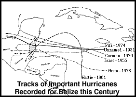
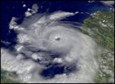
Hurricanes and Their Impact on the Reef
Hurricane season in Caribbean: June - late October (climax in mid-August)
Role of the reef: Decrease the power of very strong waves which are the results of hurricanes, thus they decrease the effect on the shore.
Impact on reef: The experts' opinions vary. Some of them argue that hurricanes are beneficial to the reef because they draw the dead organisms away and increase bio-diversity. They also argue that they disperse broken parts of the reef thus they help the reproduction of the reef.
Other experts argue that the effects of hurricanes on the reefs are more important and damaging to the reef.
Belizean Geology, Physical Features and Climate Overview
Geology: Largely consists of various limestones. Maya Mountains- granite. Regions around are Cretacious limestone- irregular topography- with numerous sinkholes, caverns, and underground streams. It will be important for the team to look carefully into the interaction of the near coastal and coastal terrain and geology with that of the reef system and environment.
Physical Features: Two main features. First, Maya Mountains and related basins and plateaus- range most of the region except the narrow coastal plain. (Highest point 1120 metres). Second, Northern lowlands and southern coastal plains- drained by 18 main rivers and numerous streams- swamps, lagoons.
Climate: Tropical (subtropical)- distinct rainy and dry season. Significant differences by region. Average temperature- (coastal) 24° C in January to 27° C in July. Average rainfal- 1,350 millimeters in the north and west, 4,500 millimeters in the south. Hurricanes have devastated various cities and towns in the past. (Five from 1932- 1992, and one recently.)
The Barrier Reef of Belize, an Overview
Longest barrier reef in the western hemisphere at 185 miles long. Cayes (islands or mangroves) are found between the mainland and the barrier reef, and around the area of the barrier reef and the of the offshore atolls.
The Lighthouse Reef atoll is the furthest from the shore, at around 60 miles off. It is one of the best tourist attractions because it has very good underwater visibility. The reef structures start at around 30 feet depth. In the middle of this reef there is the Blue Hole.
The Blue Hole is a circular limestone sinkhole around 300 feet across and 412 feet deep. The cave system that survives houses some stalactites some of which are as large as 40 inches long and 10inches wide. These caves are believed to have been flooded during the last Ice Age.
Blue Hole found approximately 60 miles off the mainland. It is surrounded by a circular reef area spanning 1000 feet in diameter. The hole falls down to about 110 feet before any cave features are met. After this depth there are stalactite formations which tilt backwards.
"The Blue Hole is a "karst- eroded sinkhole." It was once a cave at the center of an underground tunnel complex whose ceiling collapsed. Some of the tunnels are thought to be linked right through to the mainland, though this has never been conclusively proved. The mainland itself has many water-filled sinkholes that are connected to caves tunnels.
At some time many millions of years ago, two distinct events occurred. First, there was a major earthquake and this probably caused the cave ceiling to collapse forming the sinkhole. The upheaval, however, had the effect of tilting Lighthouse Reef to an angle of around 12 degrees. All along the walls of this former cavern are overhangs and ledges, housing pleistocene stalactites, stalagmites and columns.
Some of the stalactites now hang at an angle, yet we know they cannot develop at any angle other than perfectly perpendicular. In addition, there are those stalactites which were formed after the earthquake and others which were formed both before and after that cataclysmic event-the top of the stalactite being at an angle and the bottom being perpendicular. At that time the sea levels were much lower than today and the second major event was to change all this. At the end of the Great Ice Age the glaciers melted and sea levels throughout the world rose considerably. This process occurred in stages. Evidence for this are the shelves and ledges, carved into the limestone by the sea, which run the complete interior circumference of the Blue Hole at various depths. The first of these ledges is found between 150 and 165 feet (45-50 m) and is best visited on the south side. The base of the ledge is perfectly flat and cuts back into the rock some 15 to 20 feet (5-6 m). This creates an ever-narrowing cavern until the roof reaches the floor right at the back. Here in the V- shaped ledges, cut into solid limestone, are stalactites, stalagmites and columns (where stalactites and stalagmites have joined) which do not exist in the shallower waters of the Blue Hole.
Few groups have visited the Blue Hole in order to explore the tunnels and caves which extend from within. On the western side a depth of 230 feet (70 m), there is an entrance through a narrow tunnel into a large cavern. In total darkness the stalactites, stalagmites and columns exist in an undisturbed world. The floor is covered with very fine silt which billows into great clouds with the slightest movement from a passing diver. In the farthest corner, another narrow tunnel leads upwards into a second cavern and then another leads finally to a third cavern."
The Cambrian Foundation has in the past focused on research of the Blue Hole. In 1997 they have published works related to the evolution of the Blue Hole and the cave formations in it. Paleoclimatology is a field that will greatly benefit from these studies.
During the 1997 expdition of the Great Blue Hole, Kyle and Cynthia Creamer stated that "The primary objective was to locate and retrieve speleothems (cave decorations) from the bottom to help establish a time line for the rising sea levels related to continental ice sheet melting following the last ice age, thus giving us a geological history of the western Caribbean." During, and as a result of these explorations the cave systems in the Blue hole have been mapped in some detail. Pictures of the caves and the interesting speleothem formations are numerous. The close study of these cave systems is very important as "... exploration for potential cave systems leading to or from the blue hole that could be related to periods of time when the rising sea stabilized, permitting cave formation." A brief overview of the foundation's results, in the form of a press release given at the time, is interesting to note.
The Seismic Background of Belize
Every 8 years approximately, Belize experiences a 6.0 magnitude on the Richter scale subterranean earthquake in the ocean at the fault between Hunting Caye and Puerto Cortez. According to the Belize Development Trust, Belize has a 100% chance of seeing 5 earthquakes and 75% of seeing 10 in the next century. Furthermore, the Northern Lagoon where the Blue Hole is located is cut up into three reef sections separated by three wrench faults. Belize does not have a National Earthquake Information Center seismic station. Clearly with this much seismic activity and an appeared lack of seismic study in Belize, perhaps the region would benefit from more intensive seismic observation.
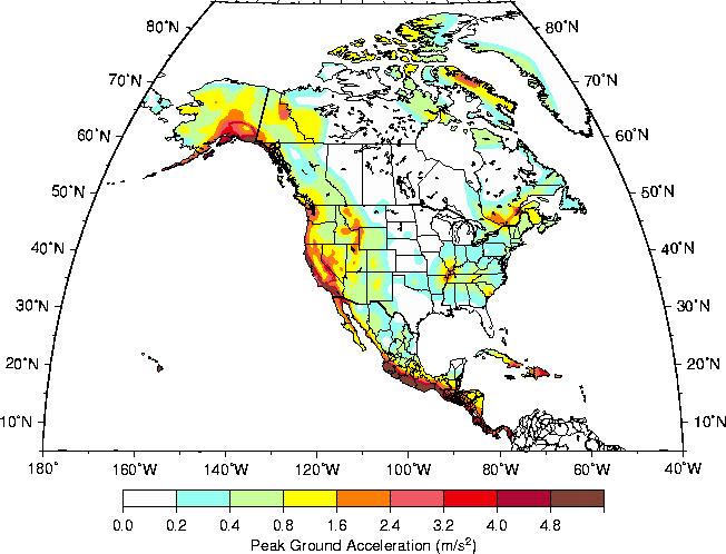
This shows the earthquake risk based on amount of ground acceleration. Ground acceleration is a good indicator of seismic activity. This demonstrates clearly how Belize and most of Central America are very at risk for earthquakes and other seismic activity.
This figure from the U.S. Geological Society explains many of the reasons why Belize is at risk. Ninety percent of all earthquakes occur along plate boundaries such as the ones in Fig.2.
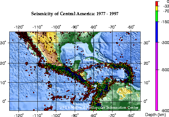
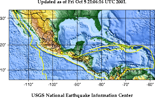
This shows the general seismicity of Central America. For more information on either of these three figures and risk due to seismic activity, see Seismic Hazard Map of the Western Hemisphere and Global Seismic Hazard Assessment Program.
Seismic Hazard Map of the Western Hemisphere goes here <---
This site contains a lot of information on risk assessment from earthquakes in Central America. It contains detailed information about faults and uses a lot of math to describe the probability of earthquakes by measuring ground acceleration. Also, it has many useful visuals.
GHSAP: North/Central America: The Global Hazard Seismic Assessment Plan contains many documents (including a risk assessment for Central America) with maps and charts on seismic activity in Central America.
Current Seismicity: This page on the website of the National Earthquake Information Center has a chart plotting the current seismicity in only Central America.
Historical Seismicity: Here, the NEIC has a map with the historical seismicity. It contains a pull-down menu for general information about earthquakes.
Belize Development Trust: The Belize Development Trust has done a risk assessment in Belize of all factors - hurricanes, war, earthquakes that would affect development. Also, the homepage contains a lot of useful and specific information about almost anything in Belize.