Solving Complex Problems
Solving Complex Problems
Questions Answered:Today Eva, Jonathan and I attended a meeting which began to outline the structure and nature of our final presentation. This is not only helpful in determining what we really need from our groups, but is also a huge motivation to get informative characterizations written, distributed (via group web pages?) and understood as soon as possible (preferably made available by the end of friday, and all read before monday). Do not forget to visit the GOALS page, linked from the yellow GOALS in the upper right.
Data, Timeline: The main database we have draws most of its figures from RADAMBRASIL, which was published by the government in 1981, there is also however some referenced material dating back to 1976 from the ministry of mining and energy, it is unknown what exactly they got from this source, and weather it was time sensitive. Several different inquiries did not reveal a more recent study under the Auspices of UNESCO or the FAO
Erosion: Aeolian is only a factor in brazil on the beaches, mainly in the shifting of sand dunes. it is not a matter we should even concern our selves with
Bedrock: Pre-Cambrian Bedrock should not be an issue, there is very little loose or mobile rock in the amazon soils or on the surface, (the rarity of rocks made and still make them a form of currency in certain parts of the Rain forest.
Erosion systems process: http://www.unu.edu/unupress/unupbooks/uu27se/uu27se04.htm this site has everything on erosion and soil conditions in humid tropics (i.e. rain forests not including canada)!
Stability: Clay soils, which are the majority of the Basin, about 4 km thick, are unstable, and have a tendency to sink and settle unevenly. This has made many major construction efforts in the amazon difficult, such as the failed Trans-Amazonian Highway
 pages, so I have barely scratched the surface in my effort
to characterize the soils. In other news, my lack of rigorously
proven data (aka scientific journal articles) has been remedied, but
once again, I have yet to sift through the sixteen articles that
I found particularly relevant to our teams perspective on the amazon (I
you are curious, or on my team, and would like to assist me in analyzing
these articles, because they are probably relevant to you too, just go to
http://web.mit.edu/ahbell/www/
, they are numbered 01-16, and are in Acrobat Reader Format). In
terms of future work (post characterization), I have several articles about
alternative farming processes, the feasibility and soil requirements for
limited reforestation, and the viability of rehabilitating or enhancing
the soil itself, which I must read thoroughly in order to understand. If
you are brave and would like to venture in to the data we are primarily
working with, or if you know Portuguese and would like to translate/explain
the column headings, please do so, just
click here
. Finally I have the chance to "get my
hands dirty" with this confirmed data, that actually means something. No
more ambiguous and misleading statements, only statistics can lie to me
now.
pages, so I have barely scratched the surface in my effort
to characterize the soils. In other news, my lack of rigorously
proven data (aka scientific journal articles) has been remedied, but
once again, I have yet to sift through the sixteen articles that
I found particularly relevant to our teams perspective on the amazon (I
you are curious, or on my team, and would like to assist me in analyzing
these articles, because they are probably relevant to you too, just go to
http://web.mit.edu/ahbell/www/
, they are numbered 01-16, and are in Acrobat Reader Format). In
terms of future work (post characterization), I have several articles about
alternative farming processes, the feasibility and soil requirements for
limited reforestation, and the viability of rehabilitating or enhancing
the soil itself, which I must read thoroughly in order to understand. If
you are brave and would like to venture in to the data we are primarily
working with, or if you know Portuguese and would like to translate/explain
the column headings, please do so, just
click here
. Finally I have the chance to "get my
hands dirty" with this confirmed data, that actually means something. No
more ambiguous and misleading statements, only statistics can lie to me
now.
Historically the Amazon was an inland Sea,
but now days it is covered in poor soils “lacking nitrogen, phosphates
and potash (
http://www.lagamar.com/Pages/ama_geog.html
).” Alluvial flood plains on the
north and west edges are significantly richer due to annual silt deposits.
According to a German study in the Amazon
Flood plain (
http://www.atb-potsdam.de/abteilungen/abt1/pdf/amazonas2.pdf
), the lack of nitrogen in the soil is
largely countered by high levels of nitrogen derived from the atmosphere
being held in trees. Luckily these nitrogen sinks are not tied
to the seasonal flooding as many had suspected, instead they are largely
dependent on species and site conditions (other than flooding).
The world over, there has been established
a relationship between the percentage of forest coverage and the population
density according to the United Nation’s Food and Agriculture Organization
(FAO, see
http://www.fao.org/sd/wpdirect/wpan0030.htm
). Within the Amazon, this trend
is demonstrated with a high resemblance to “wet ecological zones” across
the world. Also in the Amazon, the areas with the highest rates
of deforestation are also experiencing the highest acceleration of deforestation;
the danger areas are only becoming worse.
As a major consequence of deforestation,
a combination of surface runoff and soil leeching cause the topsoil
to become infertile, and unable to rejuvenate or restore the damaged
or destroyed forest (
http://library.thinkquest.org/26993/consequences.htm
).
According to organizations such as Green
Peace, in the last 30 years, an area the size of France has been carved
out of the Amazon, and the rate of deforestation is only increasing (
http://eces.org/articles/static/98990280082136.shtml
). If the land is not suitable for
farming or ranching, as research has indeed shown, then this land will
need to be abandoned for more freshly cleared Amazon in the near future,
only furthering the problem in order to sustain economic growth.
Erosion is the result of some of nature’s
most powerful forces, the wind, water and gravity constantly wearing
away at any surface they come into contact with. Erosion has been
dealt with in a variety of ways in the past, but the appropriate solution
for a region is highly dependent on the specifics of climate and the existing
land forms. While erosion stands as a negligible threat to standing
Rain forest, it is a primary symptom and excellent indicator of recently
deforested areas. It is also the greatest enemy in any reforestation,
or land fertility stabilization efforts that may be made in the Amazon.
It is a matter that needs to be further discussed at length (
).
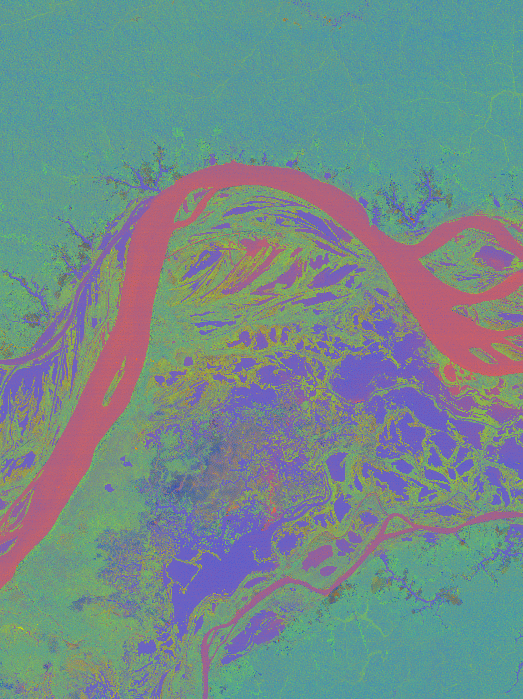
Much can be learned from satellite analysis,
such as this image of the Amazon River’s geomorphology (click on the
map for additional images).
Things are looking up for our monitoring
options, as a late 1998 study (
http://www.fao.org/sd/eidirect/eire0008.htm
) indicates that a combination of existing
data and satellite observations would allow erosion mapping in the
Amazon. The pilot program was conducted in Brazil, and suggested
that the mapping and data integration could be done for $5.30-$8.06
each square kilometer, with overall economic gains far surpassing these
expenses.
The soils of the Amazon are in a manner
of speaking, a “wet desert,” (
http://www.personal.psu.edu/users/j/m/jmh280/page1.html
) meaning that there are virtually no nutrients
in the soil itself. There is however, at layer of humus several
inches thick on the surface that consists of rapidly decaying organic
matter, and supplies the nutrients that plants rapidly absorb. This
shallow layer of viable matter causes the roots to be very shallow and outspread,
interlocking with neighbors. It is a very quick and easy transformation
from this flourishing tropical jungle to a barren desert of clay and barren
earth, turning the wet desert into a dry one.
This may be of interest not only to my
own team in respect to Land, but also to Water, and Systems Interaction
due to the plant available water, and the use of modeling (the availability
of raw data is a definite plus). So by using a record of previous
profile samplings and digitizing them to a common standard, they were
able to model not only the water content of the soil, but also the
sand, silt, clay, pH, and carbon levels. To view the maps and raw
data,
click here
.
Research suggests that in some years the
Amazon emits more CO2 than it absorbs contrary to popular belief.
It is strongly suspected (
http://news.bbc.co.uk/1/hi/sci/tech/236276.stm
) that the moisture content of the soil,
largely a function of porosity and hydrology, is the dominating factor
in deciding weather the forest absorbs enough CO2 to out run its emissions.
It has long been known that mercury contamination
has plagued the Amazon region’s flora and fauna (including the native
inhabitants). For a long time that issue had been blamed on the
mercury and other heavy metals used in the gold mining process, but a
1994 joint Canadian-Brazilian study (
http://www.idrc.ca/books/reports/1997/19-01e.html
) seemed to divert the blame from the mining
industry and point towards millennia of natural mercury build up in
the soils across the region. Recent deforestation and as a result
accelerated erosion, have unleashed years trapped mercury upon an unprepared
ecosystem.
Follow this link to my previous, less glamorous, but still possibly
useful (web page has some good links not deemed important enough
to include here)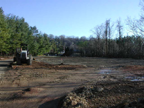

With questions or comments, write to page creator
Aaron Bell at
ahbell@mit.edu
.
Last Updated: Wednesday, 30 October, 2002
|
True International Time, Across the Universe
|