Research - Depth of the hydrocarbon reservoirs
in the 1002 Area of ANWR
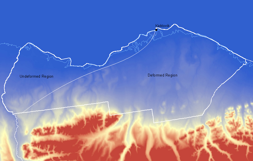
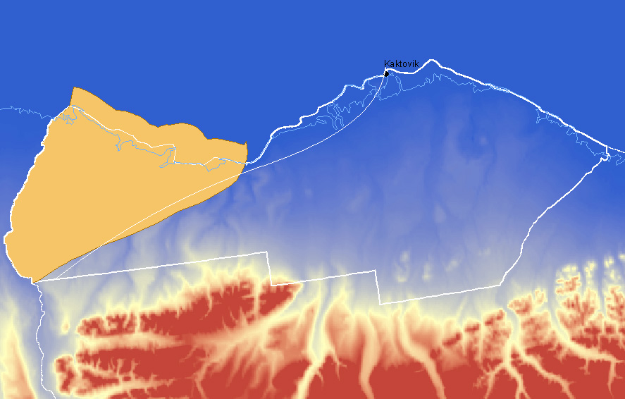
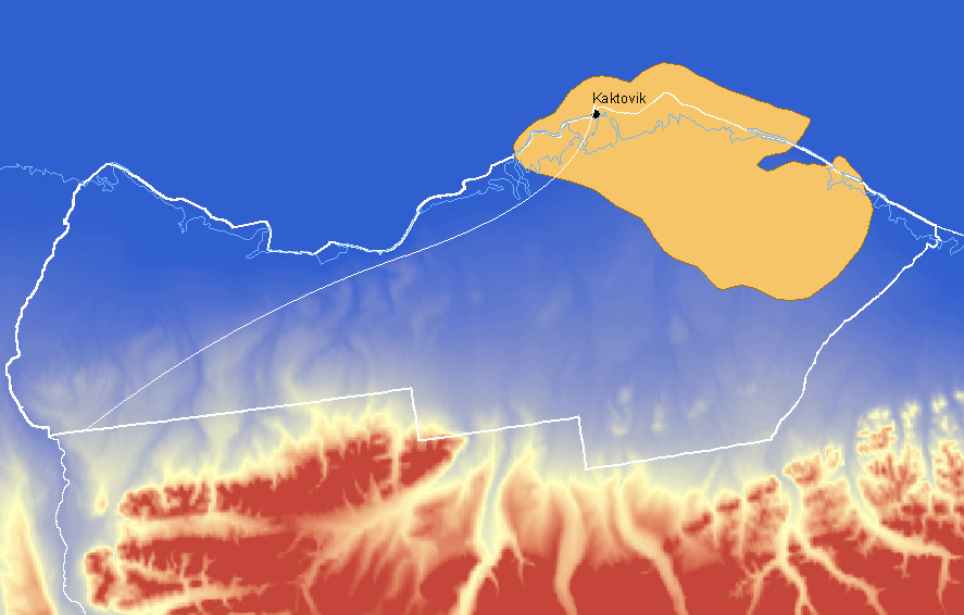
The total area considered for study in the 1999 hydrocarbon potential
assessment of the ANWR 1002 Area by the USGS considers Federal lands, Native
lands, and State waters up to the 3-mile boundary under Federal jurisdiction.
The 1002 Area was divided by a line along the Marsh Creek anticline on
its western half and along other geologic elements on its eastern half.
The area to west is the undeformed region, with rocks that are generally
horizontak, and to the east is the deformed region, which is crossed by
faults and folds. Map
Only potential accumulations larger than 50 million barrels of oil (MMBO)
in-place were considered. Smaller accumulations of hydrocarbons were not
included in the assessment because it is non-economic to produce them.
Technically recoverable oil is not evenly distributed through the territory.
Nearly 80 percent of the resources are expected to be concentrated in the
north-west undeformed area of the 1002 area.
Region |
95-percent probability |
5-percent probability |
Mean |
Undeformed area |
3.4 BBO |
10.2 BBO |
6.4 BBO |
Deformed area |
0 BBO |
3.2 BBO |
1.2 BBO |
1002 area* |
4.3 BBO |
11.8 BBO |
7.7 BBO |
Total assessment area |
5.7 BBO |
16.0 BBO |
10.4 BBO |
BBO: Billion barrels of oil
*: excluding State and Native areas
Source: BIRD, K. (1999). Geographic and Geologic Setting. In The Oil
and Gas Resource Potential of the 1002 Area, Arctic National Wildlife Refuge,
Alaska. By ANWR Assessment Team, U.S. Geological Survey Open-File Report
98-34.
It is expected to find most of the oil in several accumulations of over
100 million barrels (the size of already developed accumulations in north
Alaska), not on a single large reservoir.
Geologic Setting:
The oil- and gas-bearing geologic units found in Prudhoe Bay and the
Mackenzie Delta in Canada exist in the ANWR 1002 area. The petroleum prospective
rocks are mostly in Mississippian and younger strata.
Plays:
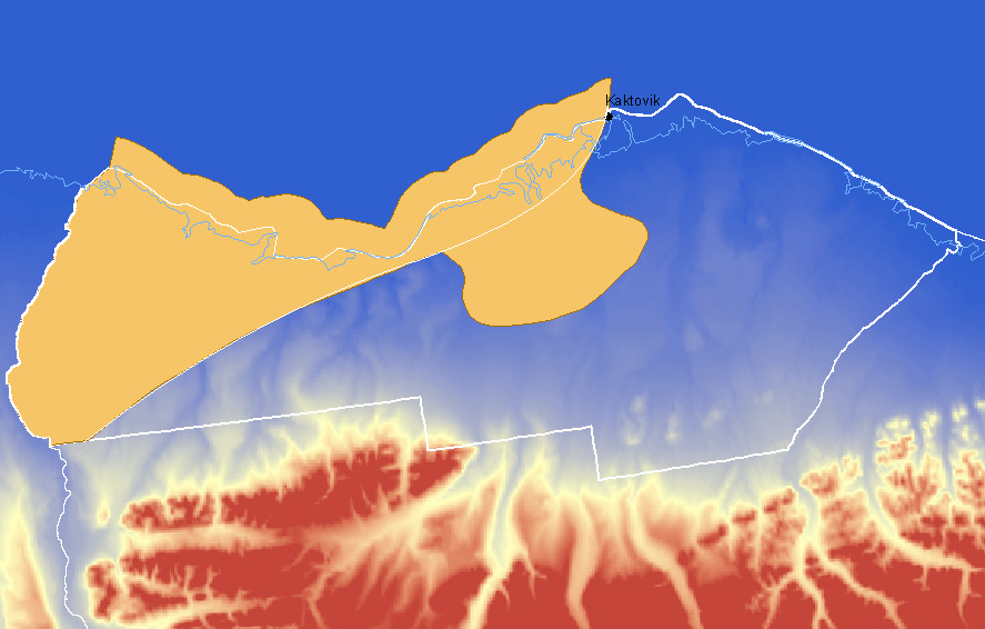
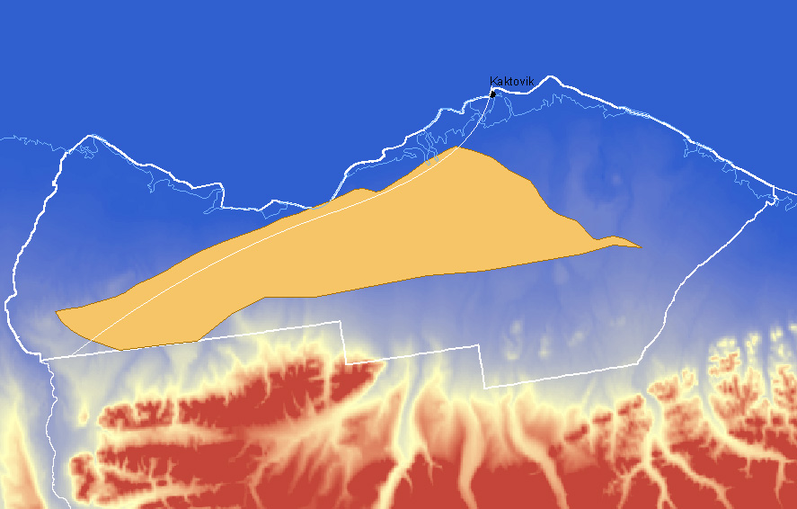
Topset Play: Map
Source: HOUSEKNECHT, D.W. & SCHENK, C.J. (1999). Topset Play. In
The Oil and Gas Resource Potential of the 1002 Area, Arctic National Wildlife
Refuge, Alaska. By ANWR Assessment Team, U.S. Geological Survey Open-File
Report 98-34.
Source: The most likely hydrocarbon source rocks are Hue Shales
in the Hue-Thompson petroleum system, and Tertiary mudstones in the Canning-Sagavanirktok
petroleum system. It is also possible that hydrocarbons generated in the
Shublik formation of the Ellesmerian petroleum system migrated and accumulated
in the Topset play.
Reservoir: Sandstones in the Topset reservoir were deposited
in both marine-shelf and non-marine environments and are the best reservoir
rocks in the 1002 area. Their porosity commonly ranges between 20 to 30%,
and their permeability between 500 and 1,000 millidarcies.
Traps: There are several types of traps in the Topset play. Anticlines
with four-way closure are few but they are the largest structures observed
in the play; they are located just north of the trend of the Marsh Creek
anticline and farther north in the 1002 area. Growth anticlines, product
of the rollover of strata and rotational growth folding, appear on the
edges of Eocene and Oligocene shelves; many have four-way closure. Growth
faults are the most common structure in the area, and their presence increases
towards the north-east. There are also up-dip shelf-edge pinchouts and
stratigraphic lenses, but they are difficult to detect using existing seismic
data.
Timing: The generation of oil in the Hue Shale unit probably
occurred 40 Ma in the southern border of the Topset play, migrated northward
through time, and occurred 10 Ma in the northern boundary. The generation
of oil in the Canning Formation probably started 10 Ma in the north and
east of the play and continues to the present.
Reservoir thickness: Minimum: 50 feet; median: 150 feet; maximum:
500 feet.
Trap depth: Minimum: 1,000 feet; median: 5,000 feet; maximum:
10,000 feet.
Water saturation: 5%, corresponding to fine- to very fine-grained
sandstone.
Number of prospects: (Number of traps with four-way closure,
capable of holding hydrocarbons) Minimum: 40; median: 80; maximum: 125.
Types of Hydrocarbons: Mean total volumes of in-place resources:
15,447.05 Million Barrels of Oil; 4,259.66 Billion Cubic Feet of associated-dissolved
and non-associated Gas; 35.33 Million Barrels of Natural Gas Liquids from
all types of Gas. Comparison to other plays: Oil is the dominate resource
with a relativistic factor of 1.959. It is the type of petroleum of most
significance in this play.
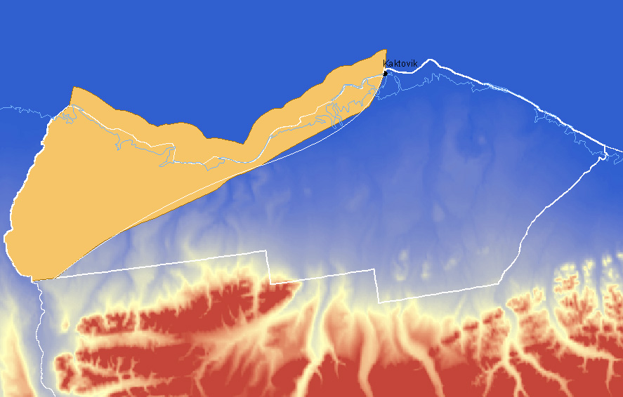
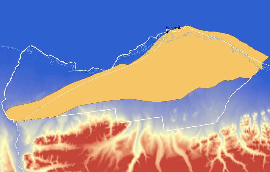
Turbidite Play: Map
Source: HOUSEKNECHT, D.W. & SCHENK, C.J. (1999). Turbidite Play.
In The Oil and Gas Resource Potential of the 1002 Area, Arctic National
Wildlife Refuge, Alaska. By ANWR Assessment Team, U.S. Geological Survey
Open-File Report 98-34.
Source: The most likely hydrocarbon source rocks are Hue Shales
in the Hue-Thompson petroleum system, and Tertiary mudstones in the Canning-Sagavanirktok
petroleum system. Turbidite rocks (sedimentary deposits from turbid currents)
are ideally placed to receive oil migrating from Hue-Thomson and Canning-Sagavanirktok
petroleum systems since they are directly in contact or a short distance
above these source rocks.
Reservoir: The sandstones in the Turbidite play are of moderate
to good reservoir-quality. The best ones are amalgamated channel facies,
which are a concentration of relatively clean (clay-free) sandstone. They
can be very thick but relatively narrow and thus hard to detect. Their
porosity is usually between 10 and 20%, and their permeability between
100 and 500 millidarcies.
Traps: The traps in the Turbidite play are hard to define because
of their stratigraphic nature. There are two major indicators of the presence
of traps, mounds and channels. In both of them, it is inferred that sandstones
are encased in mudstones, therefore forming a stratigraphic trap.
Timing: The potential rocks of this play are Paleocene and Eocene
aged turbidite facies. Formation in the Hue Shale probably started 40 Ma
(late Eocene), and more recently in the Canning Formation.
Reservoir thickness: Minimum: 50 feet; median: 120 feet; maximum:
400 feet.
Trap depth: Minimum: 7,000 feet; median: 12,500 feet; maximum:
18,000 feet.
Water saturation: 6%, corresponding to very fine-grained sandstone.
Number of prospects: Minimum: 25; median: 60; maximum: 100.
Types of Hydrocarbons: Mean total volumes of in-place resources:
5,328.05 Million Barrels of Oil; 4,665.20 Billion Cubic Feet of associated-dissolved
and non-associated Gas; 272.50 Million Barrels of Natural Gas Liquids from
all types of Gas. Comparison to other plays: Oil is the dominate resource
with a relativistic factor of 1.299. The three resources in this play,
however, have similar comparative ratios so they are all fairly significant
as petroleum resources in the Turbidite play.
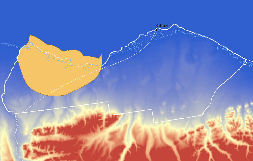
Wedge Play: Map
Source: HOUSEKNECHT, D.W. & SCHENK, C.J. (1999). Wedge Play. In The
Oil and Gas Resource Potential of the 1002 Area, Arctic National Wildlife
Refuge, Alaska. By ANWR Assessment Team, U.S. Geological Survey Open-File
Report 98-34.
Source: The most likely hydrocarbon source rocks are Hue Shales
in the Hue-Thompson petroleum system, and Tertiary mudstones in the Canning-Sagavanirktok
petroleum system. It is also possible that hydrocarbons generated in the
Shublik formation of the Ellesmerian petroleum system migrated and accumulated
in the Wedge play. This play is ideally placed to receive oil migrating
from Hue-Thomson and Canning-Sagavanirktok petroleum systems because hydrocarbons
formed in lower strata may migrate along the erosional surface at the base
of the Wedge play, directly on top of which lie the reservoir rocks.
Reservoir: The nature of the sandstones in the Wedge play is
unknown. It is possible that sediments eroded from the Staines tongue of
the Sagavanirktok Formation deposited in the wedge, but their structure
is uncertain. There is no direct evidence for the quality of the reservoirs,
but it is inferred that it may be intermediate between turbidite and Topset
sandstones because of the close relationship between their depositional
environments. There are no samples available, but from similarities with
the Turbidite play, the porosity was given the values: minimum: 10%; median:
18%; maximum: 30%.
Traps: Traps are thought to be stratigraphic, consisting of mudstones
embedded and/or overlying reservoir rocks.
Timing: The potential rocks of this play are Paleocene and Eocene
aged turbidite facies. Formation in the Hue Shale probably started 40 Ma
(late Eocene), and more recently in the Canning Formation.
Reservoir thickness: Minimum: 50 feet; median: 100 feet; maximum:
400 feet.
Trap depth: Minimum: 5,000 feet; median: 9,000 feet; maximum:
14,000 feet.
Water saturation: 4%, corresponding to fine-grained sandstone.
Number of prospects: (All traps were counted based on the assumption
that they are all stratigraphic and don't need four-way closure to hold
oil) Minimum: 10; median: 15; maximum: 35.
Types of Hydrocarbons: Mean total volumes of in-place resources:
1,677.69 Million Barrels of Oil; 864.32 Billion Cubic Feet of associated-dissolved
and non-associated Gas; 19.94 Million Barrels of Natural Gas Liquids from
all types of Gas. Comparison to other plays: Oil is the dominate resource
with a relativistic factor of 1.639. Oil is the predominate resource in
this play, but there are relatively significant amounts of Gas as well.
Thomson Play: Map
Source: SCHENK, C.J. & HOUSEKNECHT, D.W. (1999). Thomson Play. In
The Oil and Gas Resource Potential of the 1002 Area, Arctic National Wildlife
Refuge, Alaska. By ANWR Assessment Team, U.S. Geological Survey Open-File
Report 98-34.
Source: The Thompson play is formed by porous sandstones composed
of carbonate clasts of Franklinian age. The source of hydrocarbons is considered
to be the Hue Shale of the Hue-Thomson petroleum system and the Shublik
Formation of the Ellesmerian petroleum system. They are in close proximity
to the reservoir rocks, so migration of oil to them could have easily happened.
Hydrocarbons are present in the Point Thomson area, immediately west of
the play, so there is a high probability for the presence of hydrocarbons
in this region.
Reservoir: The reservoir rock for this play is the Thomson sandstone,
from the early Cretaceous, which lies directly over the Lower Cretaceous
unconformity. It contains large quantities of carbonates, and is very uniform
in character. The depositional environments probably range from trenches
to shorelines. The porosity is thought to have a minimum value of 10% and
a maximum value of 30%.
Traps: There are several types of traps in the Thomson play,
all related to the method of deposition of the sandstones over the Mikkelsen
High. The sandstones could have been deposited as blocks, as it is observed
in the Kuparuk River Field in Prudhoe Bay. It could also have been deposited
in the valleys formed by the channels that drained the Mikkelsen High during
the Lower Cretaceous, or as a sheet of sediments resulting from a rise
in sea level that caused marine sediments to be deposited over terrestrial
strata.
Reservoir thickness: Minimum: 40 feet; median: 120 feet; maximum:
340 feet.
Trap depth: Minimum: 12,000 feet; median: 15,000 feet; maximum:
18,000 feet. They provide an estimate for the hydrocarbon proportion in
the play (90% oil, 10% gas)
Water saturation: 6%
Number of prospects: Maximum: 15.
Types of Hydrocarbons: Mean total volumes of in-place resources:
805.10 Million Barrels of Oil; 1,332.28 Billion Cubic Feet of associated-dissolved
and non-associated Gas; 111.51 Million Barrels of Natural Gas Liquids from
all types of Gas. Comparison to other plays: NGL is the dominate resource
with a relativistic factor of 1.679. Compared to the amounts of NGL in
other plays, this play has NGL as its predominate resource.
Kemik Play: Map
Source: SCHENK, C.J. & HOUSEKNECHT, D.W. (1999). Kemik Play. In The
Oil and Gas Resource Potential of the 1002 Area, Arctic National Wildlife
Refuge, Alaska. By ANWR Assessment Team, U.S. Geological Survey Open-File
Report 98-34.
Source: The Kemik play is composed of sandstones deposited in
a shallow marine environment. The Kemik Sandstone is a lithic arenite,
with chert and quartz as the main lithic grain types. It was probably formed
from the the Ivishak Formation, the Lisburne Group and the Kekiktuk Formation.
Hydrocarbons probably migrated into this rocks from the Hue Shale of the
Hue Thomson petroleum system. There are traces of hydrocarbons in Kemik
Sandstone in several outcrops, indicating that they either migrated through
or have been reservoired in these rocks.
Reservoir: The Kemik Sandstone may be coarser-grained in the
north of the 1002 area, indicating a nearshore marine depositional environment,
than it is on the south, where it is a fine-grained shallow-marine sandstone.
The sandstone is probably present as valley fills and depositions from
rivers and estuaries. There may also be little reservoir-type sandstones
as much of the area was thought to be a lagoon during the depositional
time; this increases the risk associated with the play. The porosity is
estimated by the values: minimum: 10%, median: 16%, maximum: 26%.
Traps: Traps in the Kemik Play are possibly large stratigraphic
structures from the pinch-out of the Kemik Sandstone to the north of the
outcrop belt. They could also be valley-fill reservoirs with overlying
mudstones. There is also the possibility of finding structural traps created
when the Kemik Sandstones were involved in the displacement of normal-faulting.
Reservoir thickness: Minimum: 40 feet; median: 70 feet; maximum:
180 feet.
Trap depth: Minimum: 12,000 feet; median: 15,000 feet; maximum:
18,000 feet.
Water saturation: 6%, corresponding to very fine-grained sandstone.
Number of prospects: Minimum: 15; median: 24; maximum: 40.
Types of Hydrocarbons: Mean total volumes of in-place resources:
173.78 Million Barrels of Oil; 305.38 Billion Cubic Feet of associated-dissolved
and non-associated Gas; 25.59 Million Barrels of Natural Gas Liquids from
all types of Gas. Comparison to other plays: NGL is the dominate resource
with a relativistic factor of 1.717. Compared to the amounts of NGL in
other plays, this play has NGL as its predominate resource.
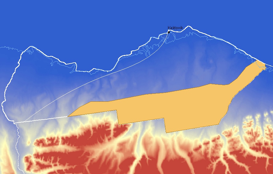
Undeformed Franklinian Play: Map
Source: KELLEY, J.S., GROW, J.A. & NELSON, P.H. (1999). Undeformed
Franklinian Play. In The Oil and Gas Resource Potential of the 1002 Area,
Arctic National Wildlife Refuge, Alaska. By ANWR Assessment Team, U.S. Geological
Survey Open-File Report 98-34.
Source: There are no known source rocks in the Franklinian sequence,
so any hydrocarbons would have to come from overlying younger formations.
The Cretaceous Hue Shale and the Canning Formation of the Brookian Sequence,
which lies directly on top of Franklinian rocks, are the most probable
source rocks and seals for this play. It could also have been charged from
the Triassic Shublik Formation to the west.
Reservoir: The predominant rock type in this play is the Proterozoic
Katakturak Dolomite (Sedimentary rock with more than 90% mineral dolomite,
CaMg(CO3)2) , which dips uniformly
to the south. Good reservoirs in the Undeformed Franklinian Play could
exist in fractured carbonates with increased porosity due to dissolution
of minerals. This porosity, along with porosity due to fracture of the
rocks, is probably of Cretaceous age. It ranges from 8 to 20%, with a median
of 14%.Because of the poor quality of the seismic data available for the
Franklinian rocks, it is difficult to assess this play.
Traps: There are only two possible locations in the Undeformed
Franklinian play where a fault could have caused a fold capable of holding
hydrocarbons. Other possible traps are buried hills with heights that range
from 100 to 400 feet. Stratigraphical and structural traps are also possible
bit there are not observable with the current seismic data.
Reservoir thickness: Minimum: 50 feet; maximum: 300 feet.
Trap depth: Minimum: 13,000 feet; median: 17,000 feet; maximum:
21,000 feet.
Water saturation: 2%, corresponding to carbonates.
Number of prospects: Minimum: 6; median: 12; maximum: 24.
Types of Hydrocarbons: Mean total volumes of in-place resources:
286.71 Million Barrels of Oil; 740.46 Billion Cubic Feet of associated-dissolved
and non-associated Gas; 71.37 Million Barrels of Natural Gas Liquids from
all types of Gas. Comparison to other plays: NGL is the dominate resource
with a relativistic factor of 2.20. Compared to the amounts of NGL in other
plays, this play has NGL as its predominate resource.
Deformed Franklinian Play: Map
Source: GROW, J.A., POTTER, C.J., NELSON, P.H., PERRY, W.J. & KELLEY,
J.S. (1999). Deformed Franklinian Play. In The Oil and Gas Resource Potential
of the 1002 Area, Arctic National Wildlife Refuge, Alaska. By ANWR Assessment
Team, U.S. Geological Survey Open-File Report 98-34.
Source: There are no known source rocks in the Franklinian sequence,
so any hydrocarbons would have to come from overlying younger formations.
The Cretaceous Hue Shale and the Canning Formation of the Brookian Sequence,
which lies directly on top of Franklinian rocks, are the most probable
source rocks and seals for this play. It could also have been charged from
the Triassic Shublik Formation to the west, or footwall source rocks (rocks
beneath a fault) of the Hue Shale and Canning Formation could have charged
the hanging walls (rocks above a fault).
Reservoir: The predominant rock type in this play is the Proterozoic
Katakturak Dolomite (Sedimentary rock with more than 90% mineral dolomite,
CaMg(CO3)2), like for the Undeformed
Franklinian play. Because of the intense faulting and folding in this area,
fractured carbonates reservoirs are probable in this play, facilitating
the formation and access to potential reservoirs. The values for porosity
range from 8 to 20%, with a median of 14%.
Traps: On the top, the Brookian Turbidite and the Hue Shale are
the most likely seals. Most of the prospects mapped in this play were bounded
by faults and needed sealing faults to achieve a significant size, but
studies of carbonate reservoirs have shown that faults in carbonate rocks
are not good seals, giving a low probability of trap formation. There are
a few four-way closures mapped on this play.
Reservoir thickness: Minimum: 160 feet; median: 300 feet; maximum:
800 feet.
Trap depth: Minimum: 9,000 feet; median: 10,500 feet; maximum:
13,000 feet.
Water saturation: 2%, corresponding to carbonates.
Number of prospects: Minimum: 5; median: 12; maximum: 20.
Types of Hydrocarbons: Mean total volumes of in-place resources:
130.55 Million Barrels of Oil; 1,213.86 Billion Cubic Feet of associated-dissolved
and non-associated Gas; 66.18 Million Barrels of Natural Gas Liquids from
all types of Gas. Comparison to other plays: NGL and Gas are the dominate
resources with relativistic factors of 1.507 and 1.589. Compared to other
plays, Oil is not very significant in this play, although there is a greater
quantity of it than both NGL and Gas.
Thin-Skinned Thrust-Belt Play: Map
Source: PERRY, W.J., POTTER, C.J. & NELSON, P.H. (1999). Thin-Skinned
Thrust Belt Play. In The Oil and Gas Resource Potential of the 1002 Area,
Arctic National Wildlife Refuge, Alaska. By ANWR Assessment Team, U.S. Geological
Survey Open-File Report 98-34.
Source and Reservoir: The Thin-Skinned Thrust-Belt Play consists
of a region of Brookian strata within the thin-skinned thrust belt. When
the Brookian rocks lie directly on the pre-Mississippian basement, the
region is composed of Cretaceous Hue Shales or mud-rich Paleocene rocks;
when Ellesmerian or Beaufortian rocks are present, it lies between the
Kingak and pebble shale interval. The structures in this play are younger
than the generation of hydrocarbons, but they may have been charged from
the undeformed area, or Tertiary source rocks could have generated hydrocarbons.
Traps: Seismic profiles show several four-way closures in this
play, and anticlinal and overlapping structures in two dimensions that
could form prospective traps if they present four-way closure.
Reservoir thickness: Minimum: 90 feet; median: 130 feet; maximum:
700 feet.
Trap depth: Minimum: 1,000 feet; median: 4,000 feet; maximum:
12,500 feet.
Water saturation: 6%, corresponding to very fine-grained sandstone.
Number of prospects: Minimum: 17; median: 40; maximum: 60.
Types of Hydrocarbons: Mean total volumes of in-place resources:
2,883.88 Million Barrels of Oil; 2,749.66 Billion Cubic Feet of associated-dissolved
and non-associated Gas; 28.51 Million Barrels of Natural Gas Liquids from
all types of Gas. Comparison to other plays: Oil is the dominate resource
with a relativistic factor of 1.275. This play also contains relatively
large quantities of gas as well, at a factor of .851.
Ellesmerian Thrust-Belt Play: Map
Source: GROW, J.A., POTTER, C.J., NELSON, P.H. & PERRY, W.J. (1999).
Ellesmerian Thrust-Belt Play. In The Oil and Gas Resource Potential of the
1002 Area, Arctic National Wildlife Refuge, Alaska. By ANWR Assessment Team,
U.S. Geological Survey Open-File Report 98-34.
Source: Source rock prospects for this play include the Shublik
Formation, Hue Shale, and Canning Formation, charging the reservoir rocks
from footwall source rocks (rocks beneath a fault) to hanging wall reservoirs
(rocks above a fault). From vitrinite reflectance mapping, it was concluded
that most of this play lies below the oil generation window, making this
a 100% gas play.
Reservoir: Potential reservoirs for the Ellesmerian Thrust-Belt
play only include the sandstones of the Ivishak and Sag River Formations,
Kekiktuk Conglomerate, and carbonates in the Lisburne Group because the
Jurassic and Lower Cretaceous rocks of the Ellesmerian formation (Kingak
Shale, Kemik Sandstone, and Pebble Shale) are too thin. The mean value
for porosity is 11%.
Traps: The subsurface continuations of the Sadlerochit Mountains,
two anticlines dipping to the east, are large prospect traps in this play.
There are four others, and they all require cross faults for closure, as
well top seals. Possible top seals are the Kingak Shale, Hue Shale or silstones
of the Canning Formation.
Reservoir thickness: Median: 300 feet; maximum: 1,500 feet.
Trap depth: Minimum: 2,000 feet; maximum: 17,000 feet.
Water saturation: 3.5%, corresponding to an intermediate between
fine sands and carbonates.
Number of prospects: Minimum: 4; maximum: 8.
Types of Hydrocarbons: Mean total volumes of in-place resources:
0 Million Barrels of Oil; 1,167.65 Billion Cubic Feet of associated-dissolved
and non-associated Gas; 23.76 Million Barrels of Natural Gas Liquids from
all types of Gas. Comparison to other plays: Gas is the dominate resource
with a relativistic factor of 1.716. There is no Oil resource in this play,
but there are the largest Gas resources of all the plays.
Niguanak-Aurora Play: Map
Source: GROW, J.A., POTTER, C.J., NELSON, P.H. & PERRY, W.J. (1999).
Niguanak-Aurora Play. In The Oil and Gas Resource Potential of the 1002
Area, Arctic National Wildlife Refuge, Alaska. By ANWR Assessment Team,
U.S. Geological Survey Open-File Report 98-34.
This play is composed of two very large structures, the Aurora dome and
Niguanak high, located to the north-east of the 1002 area. The uncertanties
of the structures present caused the play to be assessed in two scenarios:
one with two large prospects, one for each structure, and another with multiple
prospects inside each structure.
Source: Lower Cretaceous Pebble shale, Hue shale and the Tertiary
Canning Formation, all of the Brookian sequence, may occur around over
and on the flanks of the two structures that compose the play, and may
have charged them.
Reservoir: The internal deformations in these two structures
make it difficult to determine their composition, but the high densities
and velocity values measured suggest that they are composed mainly of Franklinian
rocks, with some components of Beaufortian and Ellesmerian rocks. The porosity
has a minimum value of 5%, a mean of 10% and a maximum of 20% for both
scenarios.
Traps: The north-verging Niguanak thrust fault system separates
the Aurora dome on the north and the Niguanak dome on the south. There
may be stacked thrust sheets of rock within both structures where hydrocarbons
could be trapped in basement carbonates or sandstones of the Franklinian,
Beaufortian and/or Ellesmerian origin.
Reservoir thickness: Minimum: 50 feet; median: 150 feet; maximum:
300 feet (both scenarios).
Trap depth: Minimum: 2,000 feet; maximum: 17,000 feet.
Water saturation: 2.5%, corresponding to carbonates.
Number of prospects: Many prospect scenario: Minimum: 1; median:
10, maximum: 20. Two-dome scenario: 2.
Types of Hydrocarbons: Mean total volumes of in-place resources:
1,107.04 Million Barrels of Oil; 1,178.96 Billion Cubic Feet of associated-dissolved
and non-associated Gas; 51.49 Million Barrels of Natural Gas Liquids from
all types of Gas. Comparison to other plays: Oil is the dominate resource
with a relativistic factor of 1.185. Compared to other plays, there are
also large volumes of both NGL and Gas as well in this play.
| 