|
|
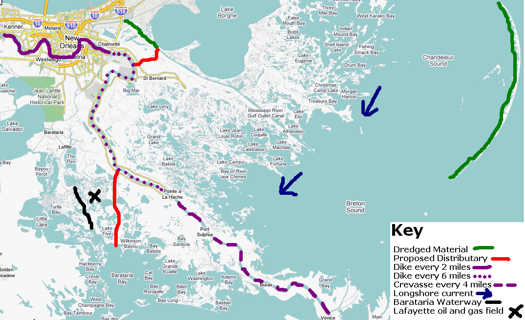
A spur dike, or wing dam, is a structure
that spans only
part of a river, while a dam, for example, spans the entire river. Spur dikes are used to control the depth of a
river by deflecting its main channel (Mioduszewski).
They can be used to decrease the width of the
channel, thus increasing its hydraulic radius and efficiency at
transporting
sediment.
Spur dikes should
be constructed
along the sides of the river, at an angle of 90 degrees to the flow
velocity. They should be constructed of
porous material, such as willow branches strapped together and layered,
again,
with quarried rock or gravel. Willow branches
are also
available at various locations along the river and could be rafted down
at a
low cost. These dikes should be above the
surface during normal water levels, and be submerged during floods,
allowing
excess water to flow over them. Since
the channel deepens as you move towards the middle, the dikes do not
need to be
as tall as the required 45 ft depth of the shipping channel. The sloping banks are 35 ft deep during
average water levels. So, the spur dikes
should be built to this height (35 ft). The
dikes should be constructed every 2 miles along the
river from Kenner, just upriver from New Orleans,
until Chalmette, just downriver from New Orleans. Between
Chalmette and
Pointe a la Hache
in the lower Plaquemines parish, the dikes should be constructed every
6
miles. Below Pointe a la Hache, there
should be at least one crevasse, that would allow water to flow out
during periods
of high water, every 4 miles. This will
allow
flood water to deposit sediment on the wetlands surrounding the main
channel
without immediately displacing the people settled on the high ground
near the
river levees.
The following estimates of how the addition
of these spur
dikes would affect the flow and sediment transport rate of the river
are based
on several basic assumptions. We assume
that the water discharge of the river is held constant, that is, the
average annual
volume of water flowing past New
Orleans, does not change and varies with the
following
equation:
D = A x V
(Nelson 2006)
where D is discharge in ft3/s, A
is the average
cross-sectional area of the channel in ft2, and V is the
average
velocity of the current in ft/s. We also
assume that the sediment carrying capacity varies with the sixth power
of the
velocity (Divener 2006). Our numbers for
the dimensions of the river channel at and below New
Orleans are according to the US Army Corps of Engineers’
report on
the Mississippi River Basin (Mississippi River Basin).
Dikes should be constructed in pairs, one on
each side of
the river, each one extending about 100 ft into the channel. This restriction of the channel will increase
the hydraulic radius of the river by approximately 30%, making it more
efficient. The average cross-sectional
area of the river past New
Orleans
should decrease by approximately 6%, causing the velocity to increase
by
approximately 6%. This small increase in
velocity translates to a 40% increase in the sediment capacity of the
river,
assuming the discharge of the river remains constant.
This increase in sediment carrying capacity
means that the river will be able to carry about 150,000 tons more
sediment
each day. If the banks are armored as
previously mentioned, this erosion will take place along the riverbed
at a rate
of approximately .002 ft/day. The
riverbed will gradually erode itself back to sea level in New Orleans,
where it is currently several
feet above street level. These dams will
initially trap more sediment, thus further
decreasing the sediment load that the river is carrying to the wetlands. However, as the dams are built up with
trapped sediment, the channel will be narrowed. The
hydraulic radius of the channel will increase, putting
more pressure
on the sediment particles on the significantly elevated riverbed. This increased pressure will decrease the
flow rate needed to erode the bottom, increasing the sediment load of
the river
and causing it to down cut into its own bank. The
river will gradually return to the level of the city.
The river
banks need to be armored to prevent
further erosion. Quarried limestone rock
held in place with a wire mesh would be most effective and cost
efficient, as
limestone is mined at various locations along the river and could be
cheaply
rafted downstream. This armoring is
particularly important in New
Orleans
proper because of the increase in channel velocity the spur dikes will
cause.
The river profile upstream of Kenner will also
be affected by the erosion
of the river bed below the beginning of the dikes.
The point where the bed erosion will begin,
originally at Kenner,
will gradually move upstream, as the gradient of the bed downstream
steepens. This upstream movement will
stop at the Old River
control structure, where it will begin to erode the 15ft difference in
elevation between the Atchafalaya and Mississippi
riverbeds (Angert 2002). The riverbed will stop eroding when it reaches
sea
level. Since the mean elevation of New Orleans is below sea level, the river will
always be
slightly above New Orleans
and the levees protecting the city from river floods will always be
necessary. However, as the river erodes
its bottom, the levees will be able to handle higher and higher levels
of flood
waters and the city’s risk level for river floods will decrease
accordingly.
There need to be two main distributaries
leading to the east
and west of the current channel. The
levees currently along the main channel should be removed below the
southern
boundary of the Plaquemines parish. Below
the boundaries of this parish, the river will be
allowed to flood
its banks periodically, both natural flood periods, to deposit sediment
in the
surrounding wetlands. The eastern
distributary channel will utilize the current Mississippi River Gulf
Outlet
(MR-GO). This channel was filled in with
an average of about 15 ft of silt by hurricane Katrina (Brown 2005),
and is
accessible only by small, shallow draft vessels until dredged. Rather than spending extra money to dredge
this channel, it should be filled in from its intersection with the
Intracoastal Waterway until the southern tip of Lake Borne. This will end the funnel effect that worsened
the storm surge from hurricane Katrina. A distributary from the Mississippi river should be directed into the
remaining
lower section of the MR-GO. This
distributary will redirect a maximum ¼ of the river’s volume (General Information About the Mississippi
River), or about 103,000 ft3 of water during normal
water
levels. The intersection of the previous
MR-GO channel and the new distributary will be marked by a flood gate
that will
control the amount of water allowed to enter the channel.
This way, during periods of low water, more
of the river’s volume can be kept in the main channel to ensure a
navigable
channel for ships.
The western distributary will take advantage
of the Wilkinson
Canal that
starts just south of Bayou
Dupont, from within the Plaquemines parish. This
is a canal dug for the oil and gas industry. However,
the major oil field in this area can
also be reached by river traffic via the Barataria
Bay waterway, which also
provides a
more direct route to the Lafayette
oil and gas field. This canal also runs
through several lakes and large pools of water that were formerly
wetlands. This means that the water here
is shallower than water closer to the gulf and will fill in with
sediment
faster than areas along the coast. These
shallow pools are also more protected than areas further down the coast.
We also want to rebuild the Chandler
barrier islands to the northeast of Head of Passes using dredged
material from
Ship Shoal, the closer of two areas off the coast of Lousiana
where sediment deposits are shallow and easily dredged.
Both of these areas are sites of former delta
lobes of the river. This dredged
material will provide more protection to wetlands developing as a
result of the
MR-GO eastern diversion. This eastern
diversion will also supply an increasing amount of sediment to the
islands as
the wetlands are built seaward. The longshore current, which flows from
east to
west along the Lousiana coastline, will carry some sediment westward
from the
mouth of the MR-GO channel, building up the wetlands and reinforcing
the
coastline between the MR-GO and the main river channel.
Image
detailing our proposal: (click for larger version)
Estimated
Costs:
- Refilling the Mississippi River Gulf Outlet (MR-GO) from
its connection with the Intracoastal Waterway to intersection with the
Violet Canal:
- 1.47 billion dollars (Dredged
Material)
- Spur Dike Construction along the Mississippi River:
- 8,775,000 dollars (Matanuska)
- Building crevasses along the Mississippi River in the
Plaquemines Parish
- 80,000 dollars (Boyer 1997)
|
|