The Warning Message
System Components
Warning Message
Integration
Resources
Warning Levels and Danger Zones
We have created two levels of warning corresponding to the severity of threat posed by a tsunami. Having well-defined criteria for each level and a clear policy for how the warning system should be used during an emergency of each level will lessen confusion and provide for expedient use of the system during an emergency.We propose the identification of danger zones along the coasts of Peru and Micronesia in order to increase the clarity of alert messages. Zones will be created and divided according to the geographical characteristics of a region including its elevation as well as the presence or absence of natural barriers that dissipate the wave. Once there is enough information about an impending tsunami, warning levels will be attributed to the respective zones. The danger zones will be well-marked, and well-publicized so that the populace will be able to quickly understand which danger zones are threatened and which areas are safe. Both the levels of warning and the danger zones will be based on the Papadopoulos-Imamura scale of tsunami intensity.
Warning Levels
Tsunami Warning
This level will be issued in case of utmost emergency and would indicate the necessity of immediate evacuation. Citizens need to be prepared for immediate relocation.Tsunami Advisory
This lower level will be used to alert the populace when a small (intensity I to IV)tsunami is detected, when a tsunami will be effecting a nearby region, and when a tsunami has been detected but it will not reach the coast for several hours. In the first case, citizens would be advised to stay away from beaches and low-areas and to use caution when in those areas. In the second case, people would be asked to prepare to take in refugees from the effected area, or to send supplies or aid workers to the effected area. In the last case, the advisory would be broadcasted repeatedly and raised to the warning level a few hours before the tsunami's impact. When operating at this level, the warning system would not need to reach every single person, so the sirens would not be activated. Instead, information about the specific nature of the alert would be sent out over the other methods and the officials holding tone alert radios would be required to notify the necessary people or make the necessary preparations.Danger Zones
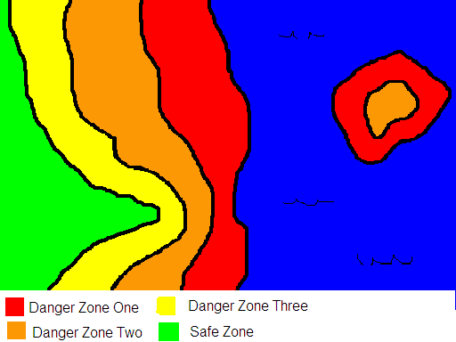
Zone One: High Vulnerability
Zone One consists of beaches and low-lying coastal areas that are vulnerable to inundation and damage from tsunamis of all levels.Zone Two: Moderate Vulnerability
Zone Two is made up of areas at risk from tsunamis of intensity VII or greater.Zone Three: Low Vulnerability
Zone Three covers areas susceptible only the most severe tsunamis, those of intensities XI and XII.Safe Zone
The Safe Zone delineates which areas are completely safe from tsunamis and are appropriate places for people to flee to in case of a high intensity tsunami.The following graphic shows what Danger Zones might look like along a coast and on a small island.
Application of Danger Zones and Warning Levels
Because the geographies of Peru and Micronesia are so different, the danger zones will be applied in slightly different ways in each country. If an Intensity VII tsunami was detected heading towards the southern regions of Peru, a Tsunami Warning would be issued for Danger Zones 1 and 2 in Tacna, Moquegna, Ica and Arequipa districts. This would indicate that Danger Zones 1 and 2 would need to be evacuated, and that all areas designated Zone 3 or Safe would be appropriate areas to evacuate to. A Tsunami Advisory might be issued for Danger Zone 1 in the district of Lima, indicating that there might be some small waves and citizens should be alert.If the same tsunami was approaching Micronesia from the east, a Tsunami Warning would be issued for Danger Zones 1 and 2 in Kosrae and Pohnpei and a Tsunami Advisory might be issued for Truk. Since some small islands might be entirely Zone 1 or just Zones 1 and 2, people on those islands would be advised to head as far inland as possible and to take shelter in brick buildings, which can usually withstand a tsunami of Intensity VII.
The Imamura-Papadopoulos Tsunami Intensity Scale1
I. Not felt.II. Scarcely felt.
a. Felt by few people onboard small vessels. Not observed on the coast.
b. No effect.
c. No damage.
III. Weak.
a. Felt by most people onboard small vessels. Observed by a few people on the coast.
b. No effect.
c. No damage.
IV. Largely observed.
a. Felt by all onboard small vessels and by few people onboard large vessels. Observed by most people on the coast.
b. Few small vessels move slightly onshore.
c. No damage.
V. Strong. (wave height 1 meter)
a. Felt by all onboard large vessels and observed by all on the coast. Few people are frightened and run to higher ground.
b. Many small vessels move strongly onshore, few of them crash into each other or overturn. Traces of sand layer are left behind on ground with favorable circumstances. Limited flooding of cultivated land.
c. Limited flooding of outdoor facilities (such as gardens) of near-shore structures.
VI. Slightly damaging. (2 m)
a. Many people are frightened and run to higher ground.
b. Most small vessels move violently onshore, crash strongly into each other, or overturn.
c. Damage and flooding in a few wooden structures. Most masonry buildings withstand.
VII. Damaging. (4 m)
a. Many people are frightened and try to run to higher ground.
b. Many small vessels damaged. Few large vessels oscillate violently. Objects of variable size and stability overturn and drift. Sand layer and accumulations of pebbles are left behind. Few aquaculture rafts washed away.
c. Many wooden structures damaged, few are demolished or washed away. Damage of grade 1 and flooding in a few masonry buildings.
VIII. Heavily damaging. (4 m)
a. All people escape to higher ground, a few are washed away.
b. Most of the small vessels are damaged, many are washed away. Few large vessels are moved ashore or crash into each other. Big objects are drifted away. Erosion and littering of the beach. Extensive flooding. Slight damage in tsunami-control forests and stop drifts. Many aquaculture rafts washed away, few partially damaged.
c. Most wooden structures are washed away or demolished. Damage of grade 2 in a few masonry buildings. Most reinforced-concrete buildings sustain damage, in a few damage of grade 1 and flooding is observed.
IX. Destructive. (8 m)
a. Many people are washed away.
b. Most small vessels are destroyed or washed away. Many large vessels are moved violently ashore, few are destroyed. Extensive erosion and littering of the beach. Local ground subsidence. Partial destruction in tsunami-control forests and stop drifts. Most aquaculture rafts washed away, many partially damaged.
c. Damage of grade 3 in many masonry buildings, few reinforced-concrete buildings suffer from damage grade 2.
X. Very destructive. (8 m)
a. General panic. Most people are washed away.
b. Most large vessels are moved violently ashore, many are destroyed or collide with buildings. Small boulders from the sea bottom are moved inland. Cars overturned and drifted. Oil spills, fires start. Extensive ground subsidence.
c. Damage of grade 4 in many masonry buildings, few reinforced-concrete buildings suffer from damage grade 3. Artificial embankments collapse, port breakwaters damaged.
XI. Devastating. (16 m)
b. Lifelines interrupted. Extensive fires. Water backwash drifts cars and other objects into the sea. Big boulders from sea bottom are moved inland.
c. Damage of grade 5 in many masonry buildings. Few reinforced-concrete buildings suffer from damage grade 4, many suffer from damage grade 3.
XII. Completely devastating. (32 m)
c. Practically all masonry buildings demolished. Most reinforced-concrete buildings suffer from at least damage grade 3.
1 - Papadopoulos, 2001
