|
The goal of research in the Eltahir group is to advance understanding of the fundamental hydrological processes and mechanisms that govern the role of the biosphere, as characterized by vegetative cover and soil moisture conditions, in the dynamics of biosphere-atmosphere interactions and the associated water cycle at regional scales. Understanding of these processes is critical to the solution of several regional environmental problems that are important to society: (1) assessment of the impact on sustainability of regional water resources due to deforestation and desertification, (2) assessment of the predictability of large-scale hydrological droughts and floods as sources of significant natural hazard, (3) assessment of the regional impacts on water resources, agriculture, and ecosystems that may result from any global change scenario.
Current research efforts are listed - click on the title to learn more about each project.
Monsoons and Malaria in Africa
Pilot Study on Biosphere-Atmosphere Interaction in Dhofar, Oman
The Role of the Biosphere in the Climate of Tropical Regions

Satellite image of vegetation types in Africa
West Africa
The objective of this project is to advance understanding of the role of the biosphere in the climate of tropical regions. During the last few years, we developed a general theory that defines the role of vegetation in sustaining large scale atmospheric circulations, and in shaping the climate of the tropics. We applied this theory in investigating the role of vegetation in the dynamics of West African monsoons and obtained new insights regarding the possible link between observed deforestation and occurrence of droughts. Although, in the past we concentrated on the problem of defining the role of the static vegetation in climate processes at the interannual time scale, we are currently investigating the two-way interactions between vegetation dynamics and atmospheric variability at decadal and longer time scales. [Sponsored by: National Science Foundation (Climate Dynamics Program);and NASA (New Investigator Program)]
Publications
Amazon
The objective of the research in the Amazon region is to evaluate the impact on regional climate and surface hydrology due to the expansion of current patterns of deforestation in Brazilian Amazonia. Earlier work in this project resulted in a new quantitative characterization of the regional hydrological cycle in the Amazon region. We explored the impact of medium-scale deforestation on climate, and proposed new mechanisms for land-atmosphere-ocean interactions over the Amazon basin. A high resolution mesoscale climate model has been developed to use satellite estimates of deforestation patterns in the Amazon in order to predict their impact on regional hydrology. The same model will assimilate information about precipitation from NASA's Tropical Rainfall Measuring Mission (TRMM). [Sponsored by: (NASA-TRMM Program) in collaboration with Professor Rafael Bras; Martin Fund for Environmental Research]
Publications

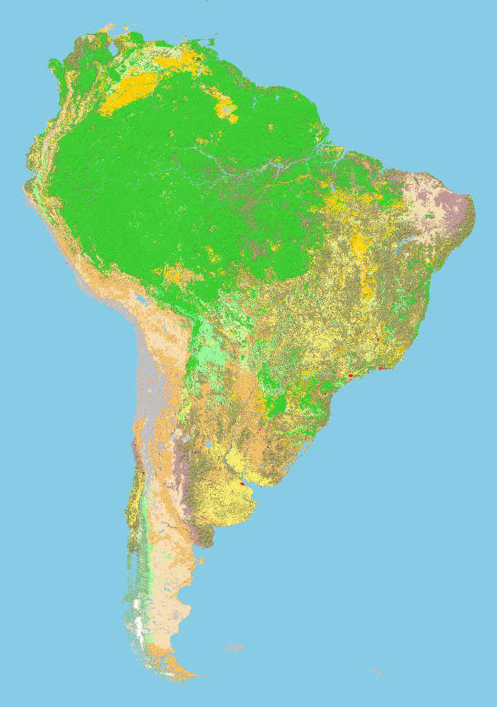
Satellite image of vegetation types in South America
El Niño and the Hydrology of Tropical Rivers

Distribution of the Surface Temperature anomalies in º C for the Pacfic Ocean, during the 1997-1998 El Niño event
El Niño is the most significant phenomenon that shapes the variability of climate in tropical regions at the interannual time scale. We are studying the relationship between Sea Surface Temperature in the Pacific Ocean, a measure of El Niño, and the flow in several large tropical rivers. The objective is to develop new methodologies for long-range forecasting of river flow, using El Niño forecasts, which can improve significantly the options for water resources management in the tropics. [Sponsored by the Sloan Foundation, and the Winslow Chair]
Publications
Topography and the Distribution of Soil Moisture |
|
| Knowledge of soil moisture distribution is needed in climate studies, for parameterizing surface hydrology and for the development of models that simulate vegetation dynamics. This project deals with describing the spatial variability of soil moisture in the root zone at large-scales (~ 3 Km). The objective is to develop a general theory which relates the spatial distribution of soil moisture to the distribution of elevation, soil type, and rainfall. Such theory will facilitate the use of the readily available data sets describing topography for the purpose of defining the spatial distribution of soil moisture. The research in this project involves development of analytical theory and collection of field data on soil moisture from Harvard Forest for validation purposes. [Sponsored by: NASA (Hydrology and Geology Programs)] Publications |
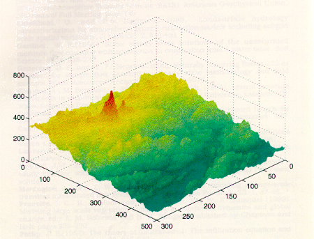
Elevation field for a (3 km x 3 km) area from Central Massachusetts |
Monsoons and Malaria in AfricaHydrological and climatological determinants of African anopheline habitat |
| Within the semi-arid Sahel zone of Africa, serious malaria epidemics arise as a result of the annual wet season. We are studying the environmental determinants of malaria outbreak occurrence in this region with the aid of numerical modeling techniques. We are involved in an inter-disciplinary study to investigate the dependence of mosquito breeding and infection rates on factors such as surface water pooling which is the result of various hydroclimatological variables. In a unique approach, individual mosquitoes in a small study area in Niger will be modeled numerically in a simulation coupled with a small-scale hydrology model. Model input will include satellite-acquired remotely sensed data for vegetation, soil moisture and topography. With results validated by field investigations, variation in mosquito abundance and infection rates will be simulated. This numerical modeling tool will shed light on dynamics of outbreak occurrence and will help the targeting of intervention efforts. The figure below shows three years of weekly malaria prevalence data. This is data obtained from the Niger ministry of health, and spans the entire country. Superimposed on this curve is daily rainfall data for one year, showing the strong response of malaria cases to the mosquito population explosion that inevitably follows extended pool persistence which mosquitoes use to breed. The peak of the malaria prevalence coincides with the end of the rainy season, most likely because mosquito populations can continue to grow up to this point.
Arne Bomblies, a doctoral student in Prof. Eltahir’s group, has established a field site in the village of Banizoumbou, Niger, joining the international team of scientists who are monitoring outbreaks of malaria and collecting measurements of the hydrologic cycle. Visit Arne Bomblies' web site for updates on the field research project, http://web.mit.edu/bomblies/www/project.htm. This research is sponsored by the National Oceanic and Atmospheric Association. |


