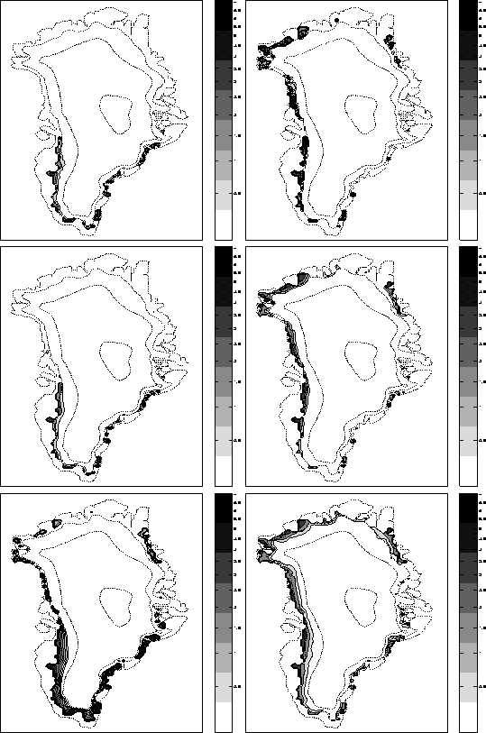
The maps in Fig.12 show the runoff from the Greenland ice sheet as calculated on a 20 km grid with the three models described in section 2, the figures in the left-hand column used the MIT climate model input while the right-hand column used the ECHAM data as model input. Table 4 summarizes the maps by comparing the total runoff originating from the Greenland ice sheet to Reeh's (Houghton et al. (1996)) estimate derived from observations. Note that the measurements of runoff are highly uncertain: Paterson (1994) suggested adding error bars of
![]() 100 . 1012 kg a-1 onto these numbers.
100 . 1012 kg a-1 onto these numbers.
 |
| ||||||||||||||||||||||||||||||||||||||||
Of the three versions which use the MIT climate model, the linear model produces the largest source area of runoff, followed by the snowpack and the PDD versions. The PDD model compensates by predicting more intense melting and runoff than the snowpack model at certain locations: Maximum runoff values are
![]() 7 m near the southeastern coast of the island instead of 5.5 m. and slightly more than 5 m on the western side instead of the 3 - 4 m. predicted by the snowpack model. The maximum values predicted by the linear model are in agreement with those of the snowpack model.
7 m near the southeastern coast of the island instead of 5.5 m. and slightly more than 5 m on the western side instead of the 3 - 4 m. predicted by the snowpack model. The maximum values predicted by the linear model are in agreement with those of the snowpack model.
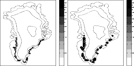
The aggregate estimates are shown to depend strongly upon the model resolution, with runoff decreasing by
![]() 20% as the grid size is halved. Figure 13 shows the difference in the extent of the source area of runoff when the resolution is doubled. This effect has been noted by Glover (1999) who attributed it to the strongly sloping margins of the Greenland coastline. According to that study, increasing the resolution beyond a
0.5o x 0.5o grid (
20% as the grid size is halved. Figure 13 shows the difference in the extent of the source area of runoff when the resolution is doubled. This effect has been noted by Glover (1999) who attributed it to the strongly sloping margins of the Greenland coastline. According to that study, increasing the resolution beyond a
0.5o x 0.5o grid (
![]() 20 x 50 km at
70oN) no longer changes the estimations of runoff, the results obtained with the finer grid can therefore be trusted as being independent of the model resolution.
20 x 50 km at
70oN) no longer changes the estimations of runoff, the results obtained with the finer grid can therefore be trusted as being independent of the model resolution.
 |
The aggregate estimates produced with the snowpack and the PDD model combinations are within 10 - 15 % of each other and 25 - 30 % lower than the observed value, the linear model predicts ![]() 70 - 80 % more runoff than the snowpack model and 30% more than observed. Because one method relies on the surface energy balance to determine the amount of melting while the other two rely only on air temperature, the reasonable agreement between these methods is reassuring as to the internal consistency of the input climate data and as to the reliability of the predictions. Note that because the MIT / snowpack model underestimates the extent of the wet snow zone along the northern coast, the
162 . 1012 kg a-1 most likely underestimates the total runoff.
70 - 80 % more runoff than the snowpack model and 30% more than observed. Because one method relies on the surface energy balance to determine the amount of melting while the other two rely only on air temperature, the reasonable agreement between these methods is reassuring as to the internal consistency of the input climate data and as to the reliability of the predictions. Note that because the MIT / snowpack model underestimates the extent of the wet snow zone along the northern coast, the
162 . 1012 kg a-1 most likely underestimates the total runoff.
The three model versions which used the ECHAM model data as input give substantially different results. There is a significant area of the ice sheet which experiences average summer temperatures in the -2 - 0oC range, thereby explaining the difference between the PDD model which ablates only for air temperatures above the melting point and refreezes the initial portion of meltwater and the linear model which predicts runoff starting at air temperatures of
-2oC. Both temperature based methods predict significantly more ablation than the model based on the energy budget which has the ability to refreeze a significant portion of the meltwater which is formed,
![]() 40% or
49 . 1012 kg/a, in particular in the Northern half of the ice sheet. This leads to a relatively low estimate for the total runoff of
122 . 1012 kg/a. In comparison, the MIT / snowpack model combination refreezes only
40% or
49 . 1012 kg/a, in particular in the Northern half of the ice sheet. This leads to a relatively low estimate for the total runoff of
122 . 1012 kg/a. In comparison, the MIT / snowpack model combination refreezes only
![]() 20% or
35 . 1012 kg/a of the meltwater which is generated.
The snowpack model refreezes in-situ all the melt- or rainwater which accumulates at the surface of the Antarctic ice sheet. This is in large part due to the strongly negative energy budget during the winter months which is responsible for the low temperatures of the snow and firn. A significant amount of energy can therefore be added to the firn as latent heat released by the freezing process before any runoff can take place. The degree-day model accounts to some degree for refreezing and predicts only a minimal amount of runoff. The linear model however generates runoff as soon as the average summer temperature reaches
-2oC which includes a large portion of the Antarctic Peninsula and areas along the coast in the
45 - 135oE quadrant. Although not entirely impossible and not inconsistent with the melt extent presented by Zwally and Fiegles (1994) , the predicted runoff of
620 . 1012 (MIT) and
122 . 1012kg a-1 (ECHAM) is much larger than the estimates derived from measurements which are thought to be close to
50 . 1012 kg a-1 (Houghton et al. (1996)). Because melting is currently limited to coastal areas, it is possible that a higher resolution than the 40 km grid which was used could change the estimate of runoff.
20% or
35 . 1012 kg/a of the meltwater which is generated.
The snowpack model refreezes in-situ all the melt- or rainwater which accumulates at the surface of the Antarctic ice sheet. This is in large part due to the strongly negative energy budget during the winter months which is responsible for the low temperatures of the snow and firn. A significant amount of energy can therefore be added to the firn as latent heat released by the freezing process before any runoff can take place. The degree-day model accounts to some degree for refreezing and predicts only a minimal amount of runoff. The linear model however generates runoff as soon as the average summer temperature reaches
-2oC which includes a large portion of the Antarctic Peninsula and areas along the coast in the
45 - 135oE quadrant. Although not entirely impossible and not inconsistent with the melt extent presented by Zwally and Fiegles (1994) , the predicted runoff of
620 . 1012 (MIT) and
122 . 1012kg a-1 (ECHAM) is much larger than the estimates derived from measurements which are thought to be close to
50 . 1012 kg a-1 (Houghton et al. (1996)). Because melting is currently limited to coastal areas, it is possible that a higher resolution than the 40 km grid which was used could change the estimate of runoff.