 |
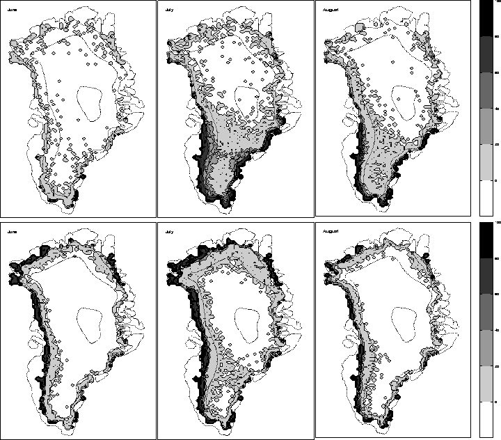
The results obtained with the snowpack model and the MIT climate are shown as the top panels of Fig.10, the ECHAM model results form the bottom panels, the three columns represent respectively June, July and August. Fig.10 is directly comparable to Fig. 4 of Abdalati and Steffen (1997). While the ECHAM model produces intense melting mostly along the western and northern coast of Greenland throughout the summer, the extent of the wet snow zone predicted by the MIT model is concentrated in the southern half of the ice sheet and extends further inland. Except for June when the extent of melting is underestimated, both the areal extent and intensity (in terms of % of days which experience melting) of the melting predicted by the MIT / snowpack model match observations fairly closely. This indicates that the total ablation predicted by this model for the entire ice sheet can be viewed as a conservative estimate of the total runoff originating from the Greenland ice sheet. The ECHAM model reproduces the observed melting along the northern coast which is not captured by the MIT model but fails to reproduce the areal extent of the wet snow zone in the southern half of the ice sheet where most of the melting occurs. This in turn leads this model combination to underestimate the total runoff when compared to observations.
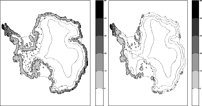
The extent of the wet snow zone for Antarctica predicted by both climate / snowpack models is shown in Fig.11, it can be compared to the observations by Zwally & Fiegles for the 1982/83 and 1983/84 summers, their Fig. 4. Since 1982/83 saw unusually high surface melting, and 1983/84 below average surface melting, the model predictions will be compared to the average of those two years. The Antarctic Peninsula usually experiences 50-60 days of melting, the MIT model sees only 40-50% of the summer or a total of 35-45 days with surface melt, the ECHAM model only 20-40% or 18-35 days during the summer. The rest of the coast (the ice shelves which are floating ice masses are excluded from the model predictions) experiences on average less than 20 days of melting which compares favorably with the 20-40% (18-36 days) predicted by the MIT model. The ECHAM model fails to give any surface melting anywhere but on the Peninsula and in the South-Western quadrant. The areal extent of the melt zone predicted by the MIT model is therefore closer to observations than that predicted by the ECHAM model. Note that virtually all of this rain and meltwater refreezes in situ and neither model combination predicts any runoff originating from the Antarctic ice sheet.
 |
The degree-day model produces a wet snow zone generally slightly smaller than that of the snowpack model, but which generally shares the same features.