There was a significant amount of development in the North End at the turn of the 19th century. Many immigrants were arriving, settling into the strong Italian community already thriving there. The streets in the 1930s have finally reached the state in which they exist today. Salem, Hanover, Prince, and N. Bennet Streets all go by the names that we use today. There are a number of schools that have been built since the mid-1800s; three alone in one of the blocks that I am examining. This indicates that the North End has become much more of a residential/family community instead of the fishing/port community that it was in centuries past.
Another indication as to why Hanover Street is more commercial than Salem Street is given on the 1930s driving map: Hanover Street was on a trolley route. The red line on the map shows the route of street railways. This enabled people to easily commute to jobs and to the North End for shopping. The Central Artery has not been built yet, and the Mill Creek was buried in 1833, so the North End is more connected to downtown Boston than it ever has been.
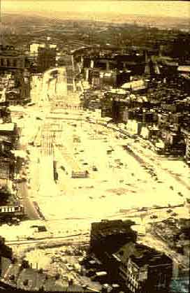
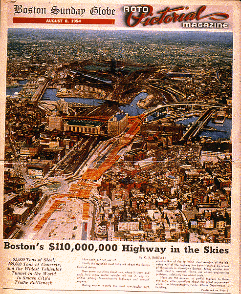
The construction of the Central Artery had the biggest impact on the North End than any other construction in the 20th century. The master plan for the Central Artery was finished in 1948, calling for a major elevated highway through downtown Boston to carry local traffic. Construction started in 1950, and in 1954 , the Central Artery opened for uses, cutting off the North End from the rest of downtown Boston. Over 20,000 people were displaced and 1000 buildings were destroyed.A view of the land cleared to make way for the Central Artery. The North End is to the right in this picture. Ā
Today, construction is still a large part of life in the North End, but the residents of the North End may finally be on the receiving end of the good works. The Central Artery is being moved underground, so if all goes well, in a number of years the "green monster" will be gone and a park will separate the North End from downtown. This will be a considerable improvement over both the Central Artery and the current construction situation, which makes the North End seem totally separate.Ā
Ā
Looking at the development of the North End over nearly three centuries provides information that helps determine why the neighborhood is what it is now. The commercial traffic that ran down Hanover Street in the 1800s provided an indication of its continued us as a main transportation thruway. Salem Street's beginning as a much narrower, quieter street is reflected today in its more residential use. Another reason why these two are so different is given in the 1890 Bromley Atlas, which shows that groups of buildings on Hanover Street were owned by the same families, while nearly all of the buildings on Salem were individually owned. In the 1900s, the North End has been able to keep its distinctly Italian feel. This is due in part to construction of the Central Artery, which has kept the North End separated from the rest of Boston since the 50s. The information obtained from old maps gives one a good idea as to why the North End is what it is today.
Ā
Ā
home