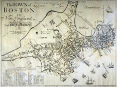
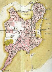
The North End was originally settled as a waterfront town. Jutting out as a peninsula into the bay, the North End had many docks protruding from its shoreline. Emphasizing the connection to the water, the streets along the south and east shores were named Ship Street and Fish Street. This indicates that the boating/fishing industry was vital to the residents of the North End in the 1700s. Mill Pond, and the dam forming it, occupied the northern side of the peninsula, with various mills located along the shoreline there. A ferry to Charlestown also left from the north shore everyday, transporting people and goods to and from the North End. The path of this ferry today would now travel across land, since much has changed around Boston since the early 1700s. This site will first explore the evolution of the streetscape of the North End and then will focus on individual aspects of the North End.
The 1700s--Developing Character
The North End was fairly well settled by the end of the first quarter of the 18th century. The street pattern today follows the rough outline laid out in 1722. The area that is now the heart of the North End juts out into Boston Harbor as a peninsula. Two main streets, one of them Middle Street, connect this landmass to the rest of Boston, since Mill Creek physically separates he north end from the rest of Boston. In this map, it appears as though the Central Artery was built over the sight of the former Mill Creek, though I can't be sure yet.click here for a close-up view of this map
The street pattern today roughly follows the street pattern laid out in 1722. However, the sections of Salem and Hanover streets that I am focusing on go by different names at this time, Back Street and Middle Street. These are very descriptive names, which seems to be the case of many street names at this time. Back street is located at what could be considered the "back" of the peninsula, since it seems most of the docks were located on the south side of the peninsula. Middle St gets its name because it runs down the middle of the neck of the peninsula.
The most interesting thing about the streets I am looking at is the fact that both Salem and Hanover Streets existed by name in 1722, but not as we know them today. Salem Street in 1722 is a part of present day Salem Street; it connects to Back Street at an angle where Back, Salem, and Prince Streets intersect. The transition from Back to Salem St. directly coincides with the change from commercial/residential to residential on present-day Salem Street. Perhaps the current situation is a remnant of the times in 1722, when Back Street was more commercial and Salem Street residential.
Present-day Hanover Street was composed of two streets in 1722, Middle Street in the stretch that I am examining, and North Street further out, once you cross N. Bennet Street. As I said before, I assume this street got its name from the fact that it runs down the middle of the peninsula. The fact that it runs straight down the middle of the land mass also indicates that this was a major commercial/trading area. The center of towns at this time tended to be the center of everything. Perhaps this is one reason why Hanover Street is so much more commercially developed than Salem Street is today. It appears that in 1722, Middle (Hanover) Street was densely populated, more so than Back (Salem) Street. [For future reference, all streets will be referred to using the name they have on the current time period's map, with the present day street name indicated in parentheses.] Again, "Hannover" Street exists; it is connected to Middle (Hanover) Street where Mill Creek runs perpendicular to the two. "Hannover" Street exists in part today, as Hanover Street, but it no longer runs into "Tremount" Street. Hanover Street now runs under the Central Artery, so to speak, and intersects Congress Street near the Holocaust Memorial.
In 1722, Mill Creek already physically separated the North End from downtown Boston. Two streets crossed this small canal. At the mouth of the creek, in Mill Pond, there is a "water mill." I do not know any other details as to what service this mill provided. In the 1728 map, you can see with the overlay of current streets, that it appears Blackstone Street runs over where Mill Creek was located.
Looking again at the overlay of current streets on the 1728 map, what I will call the first block (the one closest to the Central Artery now) covers much less area than it does today. Back (Salem) and Middle (Hanover) Streets intersect at this time, which is not the case today. Current Salem Street does not follow the layout from Back Street, but rather follows more closely what would have been the shoreline of Mill Pond. Hanover Street mimics Middle Street in location as well as width. Even in 1728, Middle (Hanover) Street was wider than Back (Salem) Street. This further backs up my guess that Middle (Hanover) Street was a center of community/commercial, since it would be wider to accommodate higher traffic flow.
click here to see a larger version of the 1764 map In 1764, all of Boston was becoming more developed; wharfs were built jutting out into the bay. The streetscape looks the same as it did in the first half of the 18th century; no filling of the Bay has occurred yet. Things evolved rather slowly over the next ten years; at the time of the Revolution, the streets follow the modern day footprints of the streets. Many smaller streets run parallel to Back (Salem) and Middle (Hanover) Streets, through two of the three blocks that I am examining. These streets do not exist as full streets today, although some of them remain as alleys. They also impacted the residential development, since a lot of the buildings were built around these small streets. In the third block, there is a playground/basketball court, which runs the length of the block and is about as wide as the street was in 1775.
onto the 1800s

